Tuesday 20 December 2022

Skulferatu #88 - Derelict Farmhouse, Upper Bardennoch, Moniaive, Dumfries and Galloway


Ah, what to do on the day they are burying a long serving monarch and you don’t really fancy being stuck in the house all day watching all that pomp and ceremony?  Well, taking a lead from a kids’ TV show I remember from the Seventies ‘Why Don’t You Just Switch Off Your Television Set and Go and Do Something Less Boring Instead?’  I did just that.  I got up off my fat backside and went out for a walk up in the hills by the village of Moniaive.


Stopping off in Moniaive first of all, I wandered through the rather picturesque and very quiet village.  Everything was shut and no-one was out on the street, I assume because they were all staying in and watching the funeral.  Though, maybe they were all at home busy writing, composing and painting, as Moniaive is one of these places that despite its size has attracted many musicians, authors, and artists.  The artist James Paterson, one of the ‘Glasgow Boys’ lived here, as did the author of ‘Black Narcissus’, Rumer Godden, the comic book writer, Alan Grant, and the musician Alex Kapranos.


In the warm, afternoon sun I walked out of the village and up a track leading through some woods and then on to a steep, grassy, and bumpy path lined by two drystane dykes.  As I walked up the hill, I could see the sky around me darkening as the rain clouds came rolling in.


A photo showing the hills outside Moniaive with trees in the foreground and a cottage on top of the main hill.   Photo by Kevin Nosferatu for the Skulferatu Project.
The rolling hills outside of Moniaive


I made it up to the rather atmospheric ruins of Upper Bardennoch Farm where I had a staring competition with a ram who after sizing me up for a bit, wandered off and kept a wary eye on me from a safe distance.  Then the rain came down.  It poured and poured and soaked right through the cheap and nasty ‘waterproof’ jacket I was wearing.  Five minutes later the rain was gone, the sun was out again, and I was drying off nicely. 


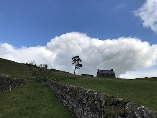
A photo of a grassy path with a drystone dyke running up along the side of it - in the distance is a derelict looking cottage type building with a lone tree standing off to one side - this is Upper Bardennoch Farm.  Photo by Kevin Nosferatu for the Skulferatu Project.
The path up to Upper Bardennoch Farm


A photo showing a derelict cottage like building with a wall off to one side and a lone tree standing slightly away from the wall.  Photo by Kevin Nosferatu for the Skulferatu Project.
The derelict remains of Upper Bardennoch Farmhouse


A photo showing a closer view of the derelict cottage like building of Upper Bardennoch Farm with a wall off to one side and a lone tree standing slightly away from the wall.  Photo by Kevin Nosferatu for the Skulferatu Project.Photo by Kevin Nosferatu for the Skulferatu Project.
The derelict remains of Upper Bardennoch Farmhouse


A view looking over a drystone wall to the ruins of Upper Bardennoch Farm.  The lone tree stands in the foreground.  Photo by Kevin Nosferatu for the Skulferatu Project.
View over Upper Bardennoch Farm


I had a wander around the ruins of the farm, which I suppose at some time in the not too distant past had been a home and a livelihood for someone but was now abandoned and falling down.  Parts of the farmhouse roof had caved in, and the doors and windows had been removed and replaced with iron bars to keep the curious out.  The remains of the outbuildings now served as nothing more than a place for sheep to shelter from the elements, with the ground in them a sludge of sheep poo and the walls a scraped fluff with tufts of wool.


A photo of a lone tree standing next to a grey drystane wall that forms a sheep pen.  Photo by Kevin Nosferatu for the Skulferatu Project.
Tree and sheep pen


A photo showing a triangular gap built into the drystane dyke wall of the sheep pen.  Photo by Kevin Nosferatu for the Skulferatu Project.
Gap in the wall


A view looking down onto fields and hills with the village of Moniaive in the centre.  Off to one side is a piece of land lit up in the sun while the rest is in the shadows of some dark rain clouds.  Photo by Kevin Nosferatu for the Skulferatu Project.
View from Upper Bardennoch over Moniaive


A photo of the ruined farmhouse of Upper Bardennoch Farm.  The windows and doors are gone with bars replacing the frames and the door.  Photo by Kevin Nosferatu for the Skulferatu Project.
Upper Bardennoch Farmhouse


I left a Skulferatu in one of the many cracks in the farmhouse walls and then I carried on with my walk to the top of Bardennoch Hill, before making my way back to Moniaive.


A photo of a small ceramic skull (Skulferatu 88) being held up with the ruined farmhouse of Upper Bardennoch Farm in the background.  Photo by Kevin Nosferatu for the Skulferatu Project.
Skulferatu #88


A photo of a small ceramic skull (Skulferatu 88) sitting in a crack in the walls of the ruined farmhouse at Upper Bardennoch Farm.  Photo by Kevin Nosferatu for the Skulferatu Project.
Skulferatu #88 in a crack in the farmhouse walls


Google Map showing location of Skulferatu #88
Map showing location of Skulferatu #88


The coordinates for the location of the Skulferatu are –


Latitude 55.206379

Longitude -3.91858


what3words: records.puppy.pocketed

Tuesday 6 December 2022

Skulferatu #87 - Machrie Moor, Arran


On Machrie Moor there stand six stone circles, so I headed off there for a wander around an ancient landscape of standing stones and distant hills.


From the car park I headed off along a gentle and winding path that led me through fields of sheep, and then out into a land of mystical magic.  There is almost something unreal about the moor, it is sort of Hollywood film set in the way it looks.  All it really needed to finish it off would be some pixies and wizards wandering around, maybe a group or two of druids...or a few hobbits.  But this is no film set, it is real.  It is a landscape of Neolithic ritual and also of everyday domestic activity with the remains of hut circles and ancient farming activity having been discovered there.


A photo of what looks like a random collection of boulders lying on a flat piece of land with some trees in the background - the stones form a stone circle known as Fingal's Cauldron Seat.  Photograph by Kevin Nosferatu for the Skulferatu Project.
Fingal’s Cauldron Seat


A picture of a ruined building with a tree growing out from where the roof once was - these are the ruins of Moss Farm.  Photograph by Kevin Nosferatu for the Skulferatu Project.
Ruins of Moss Farm


Just by the derelict buildings of Moss Farm stands a circle of stones known as Fingal’s Cauldron Seat.  This consists of a ring of inner stones and a ring of outer stones.  Local legend has it that on one of his many journeys through Arran, the warrior giant Fin McCool cooked his tea in a huge cauldron supported by the inner ring of stones and tethered his dog to one of the outer stones.


Down from the farm buildings and in a more peaty and mossy area sit, or should that be stand, a whole load more stone circles.  Some of these are made from granite boulders, while others are tall slabs of sandstone.  The stones circles are thought to date from around 4,500 years ago and were places of religious activity for many years, being used as burial sites long after they had been built.


A photo taken through the branches of a dead tree showing a standing stone in the distance on a moor with mountains in the background.  Photograph by Kevin Nosferatu for the Skulferatu Project.
Standing stone framed by dead tree


A photo of a flat moor landscape with a standing stone in the distance and mountains in the background.  Photograph by Kevin Nosferatu for the Skulferatu Project.
Standing stone on Machrie Moor


A photo of a standing stone on Machrie Moor - it is framed by mountains in the distance.  Photograph by Kevin Nosferatu for the Skulferatu Project.
Standing stone on Machrie Moor


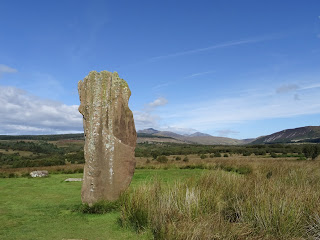
A photo of a tall and flat standing stone on Machrie Moor.  It sits in short grass with some reed like grass to one side.  Photograph by Kevin Nosferatu for the Skulferatu Project.
Standing stone on Machrie Moor


A photo of a tall and flat standing stone on Machrie Moor.  It sits in short grass with some reed like grass to one side.  Photograph by Kevin Nosferatu for the Skulferatu Project.
Standing stone on Machrie Moor


A close up of a red sandstone standing stone with mountains in the background.  Photograph by Kevin Nosferatu for the Skulferatu Project.
Standing stone on Machrie Moor


A photo showing on one side part of the red sandstone of a standing stone and then a view over the moor to the mountains in the background.  Photograph by Kevin Nosferatu for the Skulferatu Project.
View by one of the standing stones on Machrie Moor


A photo of three, tall and grey standing stones on Machrie Moor.  Photograph by Kevin Nosferatu for the Skulferatu Project.
Standing stones on Machrie Moor


A photo of three, tall and grey standing stones on Machrie Moor.  Photograph by Kevin Nosferatu for the Skulferatu Project.
Standing stones on Machrie Moor


A photo of three, tall standing stones on Machrie Moor - from closer up they have a red brown colour.  Photograph by Kevin Nosferatu for the Skulferatu Project.
Standing stones on Machrie Moor


The stone circles on Machrie Moor have long held a fascination for natives and visitors to Arran alike, with Patrick Murray writing in 1883 that – ‘...in the whole Island, I know of no more interesting sight, or one better worth visiting, than the stone circles of the Machrie Moor. As you approach them, the tall upright forms of the standing stones rise up before you, silent and solemn, from the solitary heath.  As we look on them the mind wanders backward over the ages with a strong desire to know something of the people who must have toiled and laboured at their erection. Who were they.? In what age did they live? What was the nature of their religious belief? That the circles have been used at some time as places of burial has been ascertained; but was that their original or their only use? Have they not also been used as places of worship? For answer to all this we can only conjecture, but I think we shall not greatly err if we recognise in them the silent tribute of a people long since passed away to that mysterious Power which governs the universe and overlooks the actions of man.


A photo of a red sandstone standing stone on Machrie Moor - it has a slight lightning bolt type shape to it.  Photograph by Kevin Nosferatu for the Skulferatu Project.
Standing stone on Machrie Moor


A photo of a standing stone on Machrie Moor - it is of red sandstone and is shaped slightly like a tooth.  Photograph by Kevin Nosferatu for the Skulferatu Project.
Standing stone on Machrie Moor


A photo of some circular grey and flat stones on Machrie Moor with a red sandstone standing stone behind them.   Photograph by Kevin Nosferatu for the Skulferatu Project.
Standing stones on Machrie Moor


A photo of some circular grey and flat stones on Machrie Moor with a red sandstone standing stone behind them.   Photograph by Kevin Nosferatu for the Skulferatu Project.
Standing stones on Machrie Moor


A photo of a stone circle of grey boulders.  Photograph by Kevin Nosferatu for the Skulferatu Project.
Ring of standing stones on Machrie Moor


A photo of some of the grey boulders making up the stone circle.  Photograph by Kevin Nosferatu for the Skulferatu Project.
Ring of standing stones on Machrie Moor


After a wander around the marshy ground absorbing the atmosphere of the place, and absorbing a lot of water into my rather inadequate footwear, I left the Skulferatu that had accompanied me on my trip, in a hollow, high up in one of the stones.


A photo of a hand holding up a small ceramic skull (Skulferatu 87) in front of three standing stones.  Photograph by Kevin Nosferatu for the Skulferatu Project.
Skulferatu #87


A photo of a section of a standing stone - a Skulferatu can partially be seen in a hollow in the stone.  Photograph by Kevin Nosferatu for the Skulferatu Project.
Spot the Skulferatu


A photo of a small ceramic skull (Skulferatu 87) in a hollow within one of the standing stones.   Photograph by Kevin Nosferatu for the Skulferatu Project.
Skulferatu #87 in a hollow in one of the stones


TomTom Map showing location of Skulferatu #87
Map showing location of Skulferatu #87


The coordinates for the location of the Skulferatu are –


Latitude 55.540656

Longitude -5.312024


what3words: vote.weekday.arranger


I used the following sources for information on Machrie Moor –


Information boards at the site


The Book of Arran

Edited by J. A. Balfour

1910


Natives of Arran in Glasgow

Ayrshire Weekly News and Galloway Press - Saturday 10 February 1883