Showing posts with label giant. Show all posts

Tuesday, 6 December 2022

Skulferatu #87 - Machrie Moor, Arran


On Machrie Moor there stand six stone circles, so I headed off there for a wander around an ancient landscape of standing stones and distant hills.


From the car park I headed off along a gentle and winding path that led me through fields of sheep, and then out into a land of mystical magic.  There is almost something unreal about the moor, it is sort of Hollywood film set in the way it looks.  All it really needed to finish it off would be some pixies and wizards wandering around, maybe a group or two of druids...or a few hobbits.  But this is no film set, it is real.  It is a landscape of Neolithic ritual and also of everyday domestic activity with the remains of hut circles and ancient farming activity having been discovered there.


A photo of what looks like a random collection of boulders lying on a flat piece of land with some trees in the background - the stones form a stone circle known as Fingal's Cauldron Seat.  Photograph by Kevin Nosferatu for the Skulferatu Project.
Fingal’s Cauldron Seat


A picture of a ruined building with a tree growing out from where the roof once was - these are the ruins of Moss Farm.  Photograph by Kevin Nosferatu for the Skulferatu Project.
Ruins of Moss Farm


Just by the derelict buildings of Moss Farm stands a circle of stones known as Fingal’s Cauldron Seat.  This consists of a ring of inner stones and a ring of outer stones.  Local legend has it that on one of his many journeys through Arran, the warrior giant Fin McCool cooked his tea in a huge cauldron supported by the inner ring of stones and tethered his dog to one of the outer stones.


Down from the farm buildings and in a more peaty and mossy area sit, or should that be stand, a whole load more stone circles.  Some of these are made from granite boulders, while others are tall slabs of sandstone.  The stones circles are thought to date from around 4,500 years ago and were places of religious activity for many years, being used as burial sites long after they had been built.


A photo taken through the branches of a dead tree showing a standing stone in the distance on a moor with mountains in the background.  Photograph by Kevin Nosferatu for the Skulferatu Project.
Standing stone framed by dead tree


A photo of a flat moor landscape with a standing stone in the distance and mountains in the background.  Photograph by Kevin Nosferatu for the Skulferatu Project.
Standing stone on Machrie Moor


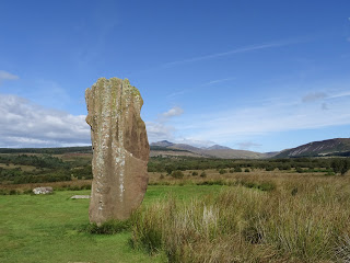
A photo of a standing stone on Machrie Moor - it is framed by mountains in the distance.  Photograph by Kevin Nosferatu for the Skulferatu Project.
Standing stone on Machrie Moor


A photo of a tall and flat standing stone on Machrie Moor.  It sits in short grass with some reed like grass to one side.  Photograph by Kevin Nosferatu for the Skulferatu Project.
Standing stone on Machrie Moor


A photo of a tall and flat standing stone on Machrie Moor.  It sits in short grass with some reed like grass to one side.  Photograph by Kevin Nosferatu for the Skulferatu Project.
Standing stone on Machrie Moor


A close up of a red sandstone standing stone with mountains in the background.  Photograph by Kevin Nosferatu for the Skulferatu Project.
Standing stone on Machrie Moor


A photo showing on one side part of the red sandstone of a standing stone and then a view over the moor to the mountains in the background.  Photograph by Kevin Nosferatu for the Skulferatu Project.
View by one of the standing stones on Machrie Moor


A photo of three, tall and grey standing stones on Machrie Moor.  Photograph by Kevin Nosferatu for the Skulferatu Project.
Standing stones on Machrie Moor


A photo of three, tall and grey standing stones on Machrie Moor.  Photograph by Kevin Nosferatu for the Skulferatu Project.
Standing stones on Machrie Moor


A photo of three, tall standing stones on Machrie Moor - from closer up they have a red brown colour.  Photograph by Kevin Nosferatu for the Skulferatu Project.
Standing stones on Machrie Moor


The stone circles on Machrie Moor have long held a fascination for natives and visitors to Arran alike, with Patrick Murray writing in 1883 that – ‘...in the whole Island, I know of no more interesting sight, or one better worth visiting, than the stone circles of the Machrie Moor. As you approach them, the tall upright forms of the standing stones rise up before you, silent and solemn, from the solitary heath.  As we look on them the mind wanders backward over the ages with a strong desire to know something of the people who must have toiled and laboured at their erection. Who were they.? In what age did they live? What was the nature of their religious belief? That the circles have been used at some time as places of burial has been ascertained; but was that their original or their only use? Have they not also been used as places of worship? For answer to all this we can only conjecture, but I think we shall not greatly err if we recognise in them the silent tribute of a people long since passed away to that mysterious Power which governs the universe and overlooks the actions of man.


A photo of a red sandstone standing stone on Machrie Moor - it has a slight lightning bolt type shape to it.  Photograph by Kevin Nosferatu for the Skulferatu Project.
Standing stone on Machrie Moor


A photo of a standing stone on Machrie Moor - it is of red sandstone and is shaped slightly like a tooth.  Photograph by Kevin Nosferatu for the Skulferatu Project.
Standing stone on Machrie Moor


A photo of some circular grey and flat stones on Machrie Moor with a red sandstone standing stone behind them.   Photograph by Kevin Nosferatu for the Skulferatu Project.
Standing stones on Machrie Moor


A photo of some circular grey and flat stones on Machrie Moor with a red sandstone standing stone behind them.   Photograph by Kevin Nosferatu for the Skulferatu Project.
Standing stones on Machrie Moor


A photo of a stone circle of grey boulders.  Photograph by Kevin Nosferatu for the Skulferatu Project.
Ring of standing stones on Machrie Moor


A photo of some of the grey boulders making up the stone circle.  Photograph by Kevin Nosferatu for the Skulferatu Project.
Ring of standing stones on Machrie Moor


After a wander around the marshy ground absorbing the atmosphere of the place, and absorbing a lot of water into my rather inadequate footwear, I left the Skulferatu that had accompanied me on my trip, in a hollow, high up in one of the stones.


A photo of a hand holding up a small ceramic skull (Skulferatu 87) in front of three standing stones.  Photograph by Kevin Nosferatu for the Skulferatu Project.
Skulferatu #87


A photo of a section of a standing stone - a Skulferatu can partially be seen in a hollow in the stone.  Photograph by Kevin Nosferatu for the Skulferatu Project.
Spot the Skulferatu


A photo of a small ceramic skull (Skulferatu 87) in a hollow within one of the standing stones.   Photograph by Kevin Nosferatu for the Skulferatu Project.
Skulferatu #87 in a hollow in one of the stones


TomTom Map showing location of Skulferatu #87
Map showing location of Skulferatu #87


The coordinates for the location of the Skulferatu are –


Latitude 55.540656

Longitude -5.312024


what3words: vote.weekday.arranger


I used the following sources for information on Machrie Moor –


Information boards at the site


The Book of Arran

Edited by J. A. Balfour

1910


Natives of Arran in Glasgow

Ayrshire Weekly News and Galloway Press - Saturday 10 February 1883


Tuesday, 29 November 2022

Skulferatu #86 - The King's Cave, Arran


To get to my walk for today to the King’s Cave, I was dropped off at a nearby car park, helpfully called Kings Cave Car Park. From there I followed the path through a woodland plantation that eventually took me out on to a steep path that descended down to a rocky and pebble strewn beach below.  There I found the King’s Cave, which is one of a series of caves in the sandstone cliffs that were formed during the Ice Age, around ten thousand years ago.


Photo showing a fancy Victorian iron fence and gate at the entrance to a cave - this is the King's Cave entrance.  Photo by Kevin Nosferatu for the Skulferatu Project.
The King’s Cave


A photo showing a series of caves in a sandstone cliff on the sea front.  In the foreground are rocks and above the caves there is a lot of vegetation.  Photo by Kevin Nosferatu for the Skulferatu Project.
The caves along the coast


A photo of a series of caves in the cliff face with the rocky beach in the foreground.  Photo by Kevin Nosferatu for the Skulferatu Project.
The caves in the cliffs


A view looking along from the rocky cliff face in the foreground, out over the sea to a rocky promontory - Drumadoon Point.  Photo by Kevin Nosferatu for the Skulferatu Project.
View from the caves down to Drumadoon Point


The King’s Cave is the largest of these caves and the name comes from the legend that Robert the Bruce once took shelter here when on the run, and that it was in this cave that he met the famous spider.  For those of you not familiar with the story, Bruce had suffered a heavy defeat by the English army and was on the run.  While taking shelter in a cave he noticed a little spider trying to weave a web.  It would get so far, then fall, but would climb back up and attempt to start again.  Eventually, after falling numerous times it succeeded in building its web.  From watching this Bruce took the lesson that ‘if at first, you don’t succeed, try, try, try again’.  He then went on to defeat the English army at Bannockburn.  Though the caves are full of little spiders, it is unlikely that there is any truth to the story or that Bruce even sheltered here.


Before the cave was known as the King’s Cave, it was referred to as Fingal’s Cave, after the legendary Irish giant Fionn mac Cumhaill or Fin McCool, which let's face it is much easier to pronounce.  What he had to do with this cave I have no idea, as all I can remember about him comes from some of the stories we were told in Primary School.  Though what I remember is not so much the actual stories but more that his size seemed to vary quite massively from story to story.  I’m sure in one he must have been about five hundred feet tall and in another he was only about twelve feet tall, which was something that even at six or seven years old I wanted an explanation for.  I wanted to understand and to make some sort of sense of how he achieved this.  Was there some sort of magic involved?  Or, like Alice in Wonderland, did he take potions that made him bigger or smaller?  Unfortunately, no satisfactory explanation was given by my teacher other than ‘they are just legends, what does it matter?’


A view of a path leading into one of the caves with the cliff face above it.  Part of the cliff face looks like a human face peering down on to the path.  Photo by Kevin Nosferatu for the Skulferatu Project.
Cave and cliffs


A view of the caves in the rock face.  Photo by Kevin Nosferatu for the Skulferatu Project.
The caves


A view into the entrance of one of the caves.  Photo by Kevin Nosferatu for the Skulferatu Project.
A view into one of the caves


A view looking out to the sea from one of the caves at the King's Caves.  Photo by Kevin Nosferatu for the Skulferatu Project.
Looking out from one of the caves


A view inside one of the caves - it is full of boulder type rocks and at the very back there are some drawings on the roof.  Photo by Kevin Nosferatu for the Skulferatu Project.
Inside one of the caves


After exploring all the caves, I sat on a rock by the beach and dozed in the warm afternoon sun.  Then, feeling lovely and refreshed I got up, left the Skulferatu that had accompanied me on my walk in the King’s Cave and ambled off back through the woods.


A photo of a small, ceramic skull (Skulferatu #86) being held up with the King's Caves in the background.  Photo by Kevin Nosferatu for the Skulferatu Project.
Skulferatu #86


A photo of a small, ceramic skull (Skulferatu #86) in a gap inside one of the cave walls.  Photo by Kevin Nosferatu for the Skulferatu Project.
Skulferatu #86 in a gap inside the cave walls


Google Map showing the location of Skulferatu #86
Map showing the location of Skulferatu #86


The coordinates for the location of the Skulferatu are –


Latitude 55.526129

Longitude -5.353452


what3words: practical.unwanted.boss


I used the following sources for information on the Kings Caves –


Arran of the Bens, the Glens and the Brave

by MacKenzie MacBride

1911


The Book of Arran

Edited by J. A. Balfour

1910