Tuesday 27 October 2020

Skulferatu #3 - Eagle Rock, South Queensferry


My Covid reading for the last few weeks has been ‘I, Claudius’ and ‘Claudius the God’ by Robert Graves.  So, immersed in stories of ancient Rome and the Emperor who conquered a large part of Britain, I thought I’d take a walk out to Eagle Rock.  As a child, one of my friend’s and I had often played on the beach, in the area of the rock.  The Historic Scotland plaque pointing out the eagle was not in place at the time and we hadn’t really noticed or paid any attention to the carving on the rock.  Then one day my friend’s dad pointed out the eagle and told us it dated from the time of the Romans.  The rock then sort of took on a magical significance, imbued with all that ancient history, and we would often imagine ourselves as Roman legionnaires in a foreign and hostile land.


Eagle Rock


The eagle on Eagle Rock is a very worn carving, which is thought to date from around AD 140 to the early AD 200s.  At this time, the Romans occupied nearby Cramond and had a fort there.  It is unclear whether the eagle was a piece of Roman graffiti art or if it had any religious significance.


The worn carving of the eagle and Historic Scotland Plaque


To get to the rock I walked through Cramond and then over the old bridge which took me on to the road to Lord Rosebery’s estate.  On the estate there is a well-worn path that follows the coast around to South Queensferry.  Despite it being a warm day with the sun out, the path was a muddy sludge from the recent rain.  So, slipping and sliding I made my way down to the short stretch of beach by Eagle Rock.  Overhead a single plane flew, its wheels down and engine roaring as it came into land at nearby Edinburgh Airport.  A reminder of the time before Covid when planes would be roaring overhead every few minutes as they came into land or were taking off.  


View of Eagle Rock looking over the Forth to Fife


On the beach the tide was out and some kids played while their parents laid out a picnic on a battered looking old rug.  They waved hello as I walked past them and along to Eagle Rock.  There, I walked around and took a few photos before looking for a suitable place to leave the Skulferatu.  There was a nice, pocked ledge below the eagle, so I left it there and walked off to rejoin the path and make my way home.


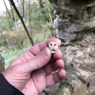
Skulferatu #3


Skulferatu #3 in situ


The coordinates for the location of the Skulferatu are – 


Latitude 55.982954 

Longitude -3.308492  


Google Map showing location of Skulferatu


Article and photographs are copyright of © Kevin Nosferatu, unless otherwise specified.

Tuesday 20 October 2020

Skulferatu #2 - Auldhame Castle, East Lothian

I arrive at North Berwick Railway Station at around lunchtime and walk out of the town and along the coast road.  The waters of the Forth are grey and choppy and the Bass Rock is still white with the thousands of gannets who came to nest on it during the summer.  They will soon fly off to the warmer climes of Morocco.  As the cold wind from the sea cuts through me I think that one day it would be nice to follow them for a bit of winter warmth.


The pavement along the road soon ends and I walk along the grass verge and past Tantallon Castle.  An imposing ruin perched on the cliffs above the sea.  About a mile further on I come to the road that leads down to Seacliff and the beach there.  I follow this down for a little while and then turn off into a muddy path through the woods.  Through the nettles and dying back stalks of plants unknown I walk to the dark and overgrown ruins of Auldhame Castle. 
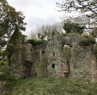
 

 A picture of the ruins of Auldhame Castle, the sea facing wall of which is all that remains relatively intact.  Photo by Kevin Nosferatu for the Skulferatu Project.

The sea facing wall of Auldhame Castle


A photo of a ruined, stone doorway that is standing on its own in some woodland.  This being one of the doorways for Auldhame Castle.  Photo by Kevin Nosferatu for the Skulferatu Project.
Castle doorway


The castle sits on the cliffs that overlook Seacliff beach, in an area where one of the three corpses of Saint Baldred of Tyninghame is said to be buried.  Saint Baldred was a Northumbrian monk who is believed to have founded an abbey at Tyninghame.  He also had a small hermitage on the Bass Rock, though sometimes lived in a cave on Seacliff beach.  After his death there was a disagreement between three of the parishes, he had close association with, as to who should get his body.  Holy men from each parish spent the night together in prayer and the next morning there were three bodies of Saint Baldred lying there - one for each parish.  So, everyone went home happy with a body to bury.


Auldhame Castle was built in the early 16th century for Sir Adam Otterburn (1491-1548). He was a lawyer and a diplomat who served the Scottish Monarchy.  He was the Kings Advocate to James V of Scotland and Secretary to Mary of Guise.  He also served as the Provost of Edinburgh.  In 1534, on behalf of King James V of Scotland, he went to London and signed a border peace treaty between Scotland and England.  In 1536, he was again sent to London after Henry VIII had requested a meeting with James V.  There he discussed the motives for the meeting and also what the agenda would be.  In 1538 he wrote a speech to welcome Mary of Guise to Edinburgh, who had recently married James V.  Otterburn then had a bit of a falling out with James and spent some time in prison before being deprived of his office and fined £1000.  When James died in 1542, the Earl of Arran took over as Regent and politics in Scotland heated up somewhat with various factions and rivalries forming.  Henry VIII of England made an agreement with the Earl of Arran that the daughter of James, the infant Queen Mary of Scots, should marry his son, Prince Edward. Some in Scotland favoured the marriage while others preferred to keep their alliance with France.  Mary of Guise persuaded the Earl of Arran that the agreement should be reneged, and this then led to an English invasion, which was given the name the Rough Wooing.    In 1544, the English army landed at Granton and Otterburn was sent to negotiate with them.  However, they refused to negotiate and burned the town of Leith and parts of Edinburgh.  In 1547, Otterburn travelled to Hampton Court to negotiate with the then King of England, Edward VI, to try and avoid the conflict between the two countries resuming.  Again, his negotiations failed, though he was sent away with a gift of £75 for his efforts.  He then wrote to the Earl of Arran telling him about the preparations he had seen the English army making and how ready and prepared they were for war.  The earl of Arran ignored his warnings, and the Scottish army was defeated at the Battle of Pinkie later that year.  In 1548, Otterburn died after being assaulted in Edinburgh by the Laird of Annestoun, Patrick Mure, who was a servant of the Earl of Arran.  Mure and his son were charged with treason and murder, but it is unclear what happened to them and if any further proceedings took place.


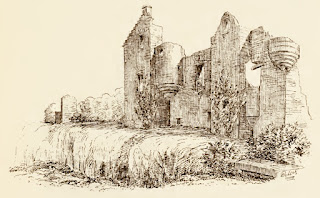
Auldhame Castle was originally an L plan tower house.  The main building consisted of three storeys with a projecting stair tower. 


A sketch of the ruins of Auldhame Castle taken from The Castellated and Domestic Architecture of Scotland from the Twelfth to the Eighteenth Century  Volume Four  By David MacGibbon and Thomas Ross, published in 1892
The ruins of Auldhame Castle circa 1892


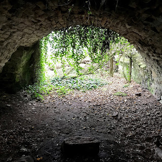
There is not much left of the building now, just the outer wall that faces to the sea and part of the vaulted basement.  In the basement someone has built a barbecue with old stone and a wire shopping basket.  It looks quite new and is maybe someone’s Covid hidey-hole.  It is sheltered from the wind and with a fire going it would be quite a comfortable drinking den.


A photograph of the arched stone basement of Auldhame Castle.  Photo by Kevin Nosferatu for the Skulferatu Project.
Castle basement


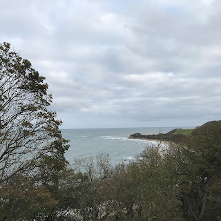
Outside, against the inside of the outer wall, a tree has fallen, and I scramble up this to a ledge by one of the second storey windows.  The view from this must have been pretty spectacular back in the day but is now blocked by dense woodland.  Below me I can hear the waves crashing on the beach and children shouting.  Around me crows caw and pigeons coo and small creatures scrabble around in the undergrowth.


A photograph of the view from the clifftop by Auldhame Castle out over the sea.  Photo by Kevin Nosferatu for the Skulferatu Project.
View from the clifftop by Auldhame Castle


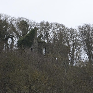
A picture of Auldhame Castle almost hidden amongst the trees on the hill on which it was built.  Photo by Kevin Nosferatu for the Skulferatu Project.
View of Auldhame Castle from Seacliff


Near to the window, there is a narrow opening in the wall.  I place a Skulferatu there and scramble back down. 


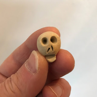
A picture of a hand holding a small, ceramic skull, Skulferatu #2.  Photo by Kevin Nosferatu for the Skulferatu Project.
Skulferatu #2


A small, ceramic skull, a Skulferatu, placed in hole in the wall in Auldhame Castle, North Berwick, East Lothian.  Photo by Kevin Nosferatu for the Skulferatu Project.
Skulferatu placed in hole in the wall


Google Map showing location of Skulferatu at Auldhame Castle, North Berwick, East Lothian
Google Map showing location of Skulferatu


The coordinates for the location of the Skulferatu are –


Latitude 56.053061

Longitude -2.639833


I used the following sources for information on Auldhame Castle –


Castles Today

History of Auldhame Castle


Wikipedia

Adam Otterburn

Auldhame Castle


The Castles of Scotland

Auldhame | Seacliff | The Castles of Scotland


Sketch of Auldhame Castle from -

The Castellated and Domestic Architecture of Scotland from the Twelfth to the Eighteenth Century

Volume Four

By David MacGibbon and Thomas Ross

1892


Tuesday 13 October 2020

Skulferatu #1 - Holyrood Park, Edinburgh

It is a grey and wet October morning as I walk to Holyrood Park, around Arthur’s Seat and then on to the ruins of St Anthony’s Chapel.  A decade or so ago I lived in Edinburgh, near to Holyrood Park, and on many a summer morning would walk up to the ruins of this chapel and sit by its walls to watch the world below go by.  As the rain lashes me and soaks through my supposedly waterproof jacket, I wish it were summer again…then at least the rain might be warm.


View of St Anthony’s Chapel from St Margaret’s Loch


The ruins of St Anthony’s Chapel stand on a hill overlooking St Margaret’s Loch, on the northern side of Arthur’s Seat.  The chapel is thought to date from the early 15th Century, as in 1426 it is recorded that the Pope gave money for its repair.  It is believed that the chapel could have been linked to the Preceptory of St Anthony, a skin hospice, which was based in Leith at around this time.  St Anthony being the saint who was believed to offer protection against skin diseases.  There is also a tradition that the chapel was founded to guard the nearby Holy Well.  This is a spring on the slopes of the hill which, like the chapel, is dedicated to St Anthony.


The chapel and the well are both the settings for a scene in Wilkie Collins’ novel ‘The Two Destinies’. This was published in 1876 and explores the themes of ‘destined spirits’ and supernatural visions.  Though it is basically just a story of boy and girl meet, lose each other due to class snobberies and then find each other again, with lots of twists and turns on the way there. 


St Anthony’s Chapel


St Anthony’s Well – Holy Well


In my jacket pocket I have the first of my Skulferatus to leave behind as a memento of my walk. As the rain pours down, I take it out and leave it in a gap in the rocks between St Anthony’s Chapel and the Holy Well.  I place it under what appears to be a wild mint plant growing there.  I find this rather apt, given St Anthony’s association with the cure of skin disease and that mint is used in various skin care treatments.


Skulferatu #1 before being placed in rocks


Google Map showing location of Skulferatu


The coordinates for the location of the Skulferatu are – 


Latitude 55.950650 

Longitude -3.161544.  


Article and photographs are copyright of © Kevin Nosferatu, unless otherwise specified.


Tuesday 6 October 2020

The Skulferatu Project

I often go walking, either in my locality or on trips and travels around the UK.  On my walks I like to explore the places I am passing through and will often end up on paths with no idea of where I’m going or what I’m going to find.  Mostly I find dead ends or industrial estates, but sometimes I find real gems of places.  These places need not be beautiful or even of any historic significance, as I have often found inspiration in the decay of old industry, in the brittle stone of crumbling graveyards or the low hum and concrete landscape of a nuclear power station.  However, sometimes it is good just to lose yourself in the beauty of nature - on a beach, on a cliff walk, in a woodland, on a moor or up in the hills and mountains.


During the time of the Covid 19 pandemic, I got to thinking about the places I have walked around and the places I have visited.  Many times, I have picked up a pebble or a shell or something else as a memento of that place, as many others do.  What do I leave of myself in this landscape though?  Nothing other than the passing shadow of my having been there.  But how often is what we leave behind us the toxic trash of the brief time we enjoyed in that place?  The plastic water bottle, the crisp packets, the sandwich wrappers, the juice cans, etc.  The detritus we are all use to seeing on our beaches and in our beauty spots.  I wondered if there was a way I could leave behind a little of myself, something I had made, something neutral that would become part of that landscape, decay back into it, or even become a memento for someone else who had visited that spot.  I then came up with the idea of leaving behind something made of clay.  Something small and unobtrusive.


I was pondering on what I could make, especially given my limited skills, while I was out for a walk along the coast.  My route took me past an old church and there I wandered through the graveyard.  Many of the graves dated from the sixteenth century.  As I wandered around, I noticed that several had very primitive carvings of skulls on them that were really nothing more than an oval head, two round holes for eyes, a triangle for a nose and a line for the mouth.  Even I could make something that basic.  Thus, the idea for the Skulferatus was born.


Skulls decorating gravestones at Cramond Kirk and Melrose Abbey


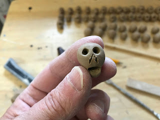
The Skulferatus are all made of clay using a few simple implements to create the eye sockets, nose and mouth.  I experimented with a few looks and found the one pictured below worked the best. 


Skulferatu Design by Kevin Nosferatu
Skulferatu design


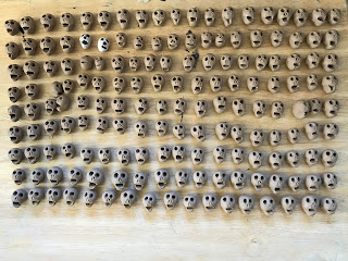
Batch of Skulferatus made by Kevin Nosferatu
Batch 1 of Skulferatus left to dry


Once made the Skulferatus were left to dry before being fired in a kiln at 1200℃.  This hardens the clay and means they are now basically stone.


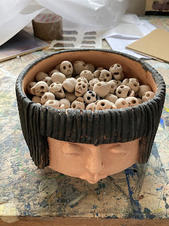
A batch of Skulferatus in a head waiting to go into the kiln to be fired
To be fired the Skulferatus were placed, rather aptly, inside a head by Ronnie Fulton.


A Skulferatu after being fired in the kiln.  Photo by Kevin Nosferatu
A Skulferatu after being fired in the kiln.


Now that the Skulferatus have been created I will be occasionally leaving them at places I visit.  When I do this, I will take a photograph of the area, a photograph of the Skulferatu and a screenshot from Google Maps, showing the location it was left.  These photographs, along with the GPS coordinates will be posted on this blog and also on Instagram.


Thanks to Esther Cohen and Ronnie Fulton from Tantallon Arts and Crafts Studios https://tantallonstudios.com for providing support in creating the Skulferatu pieces.


All articles and photographs on this blog are copyright of © Kevin Nosferatu, unless otherwise specified.