Showing posts with label Skulferatu. Show all posts

Tuesday, 24 August 2021

Skulferatu #41 - Leith Walk Railway Bridge, Leith, Edinburgh


Today I went for a walk to Leith Walk Railway Bridge, a place that is no more and was taken down years ago.  However, the viaduct buildings and the abutments that the bridge sat on are still there.


Remains of Leith Walk Railway Bridge on Jane Street, Leith, Edinburgh with tram works running along Leith Walk.  Photo by Kevin Nosferatu for the Skulferatu Project
Remains of Leith Walk Railway Bridge on Jane Street


The bridge was built as part of Caledonian Railways, New Leith Line, that ran from Newhaven to the east of Leith Docks.  It crossed over Leith Walk from the viaduct at Jane Street over to the viaduct at Manderston Street and on to the docks.  An elevated two platform passenger station was also built at Manderston Street but was never used.  The railway never carried passengers and was instead used as a goods line.  The line was closed in 1968.  The bridge was dismantled and taken down in 1980.


The Leith born poet, Jock Scot, recalled that he used to live near to the bridge, and it was something he saw as being part of the fabric of Leith Walk.  One day he and his family went off on holiday and when he came back the bridge was gone.  Being upset about the disappearance of the bridge he wrote a poem for it called ‘Farewell to Ferodo.’ 


Today, on a hot summer’s day I took a stroll down Leith Walk accompanied by the noise of heavy machinery from the ongoing tram works, that take up much of the road and pavement at the moment.  I then cut round the back of the buildings that ran along the Walk to the bridge.  Most of these are now empty and will form part of a development project that is rumbling its way through the council Planning Department.  There is then a dirt path that leads up to where the railway ran.  It is fenced off, but part of the fence has been removed, so it is easy to gain access to…for just now anyway.


The walls that run along the viaduct buildings on the Jane Street side of Leith Walk are colourful with graffiti, while the track bed for the railway is now very overgrown.  Looking out over the walls there were some great views over Leith and up Leith Walk into Edinburgh.


Site of the railway that led to the bridge - now a grassy area with heavily graffitied brick walls running alongside. Photo by Kevin Nosferatu for the Skulferatu Project
Site of the railway that led to the bridge


Site of the railway that led to the bridge - a grassy area leading down to a wall that blocks off the area where the bridge used to stand.  A lone telegraph pole stands in the corner by the wall.  Photo by Kevin Nosferatu for the Skulferatu Project
Site of the railway that led to the bridge


Graffiti on wall running up to site of bridge - graffiti of colourful faces that all have tears running from their eyes.  The word kidneys is painted beside them.  Photo by Kevin Nosferatu for the Skulferatu Project
Graffiti on wall running up to site of bridge


Graffiti on wall running up to site of bridge - spray painted, colourful skulls of the type seen at Day of the Dead.  Photo by Kevin Nosferatu for the Skulferatu Project
Graffiti on wall running up to site of bridge


Graffiti on wall running up to site of bridge - the word Paper with an exclamation mark is spray painted in red and silver.  A building standing on Leith Walk can be seen in the left hand corner of the photo.  Photo by Kevin Nosferatu for the Skulferatu Project
Graffiti on wall running up to site of the bridge


Wall blocking off gap where bridge once stood - it is spray painted with skulls and tags.  Buildings from the other side of Leith Walk can be seen.  Photo by Kevin Nosferatu for the Skulferatu Project
Wall blocking off gap where bridge once stood


View across Leith Walk to the other side of viaduct on which the bridge stood. A bus is passing by below in Leith Walk.  Photo by Kevin Nosferatu for the Skulferatu Project
View across Leith Walk to the other side of viaduct on which the bridge stood


View from Leith Walk Bridge up to Arthur’s Seat - view over the roof tops of houses to a large hill.  Photo by Kevin Nosferatu for the Skulferatu Project
View from Leith Walk Bridge up to Arthur’s Seat


View from bridge over rooftops up to Calton Hill - view over the flat roof of a group of commercial units up to a hill with a monument standing on it.  Photo by Kevin Nosferatu for the Skulferatu Project
View from bridge over rooftops up to Calton Hill


View from bridge up Leith Walk to Calton Hill - view of rows of tenement houses up to a hill with monuments on it.  Photo by Kevin Nosferatu for the Skulferatu Project
View from bridge up Leith Walk to Calton Hill


I left the Skulferatu that accompanied me on today’s walk in a gap in the wall near to some metal girders that would have once been part of the bridge over Leith Walk.  


Skulferatu #41 - a small, clay skull being held up with a view of the remains of the Leith Walk Railway Bridge in the background.  Photo by Kevin Nosferatu for the Skulferatu Project
Skulferatu #41


Skulferatu #41 in wall at remains of Leith Walk Railway Bridge - Skulferatu is in a gap in the wall next to an iron block with rivets in it. Photo by Kevin Nosferatu for the Skulferatu Project
Skulferatu #41 in wall at remains of Leith Walk Railway Bridge


Skulferatu #41 in wall at remains of Leith Walk Railway Bridge - a close up view of the Skulferatu in the gap in the wall. Photo by Kevin Nosferatu for the Skulferatu Project
Skulferatu #41 in wall at remains of Leith Walk Railway Bridge


Google Map showing location of Skulferatu #41
Map showing location of Skulferatu #41


The coordinates for the location of the Skulferatu are –


Latitude 55.968975

Longitude -3.173440


Tuesday, 6 July 2021

Skulferatu #36 - Crichton Castle, Crichton, Midlothian


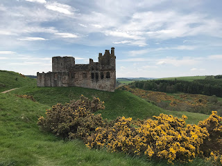
Today I went for a wander out of Edinburgh and along to the ruins of Crichton Castle.  The ruins sit just outside the village of Crichton, on a terrace that overlooks the picturesque scenery of the valley of the Tyne. 


View of Crichton Castle, Midlothian on a hill with gorse bushes flowering in yellow in the foreground.  Photo by Kevin Nosferatu for the Skulferatu Project.
View of Crichton Castle


Crichton Castle from hill above.  Photo by Kevin Nosferatu for the Skulferatu Project.
Crichton Castle from hill above


The stable block with the castle in background.  Photo by Kevin Nosferatu for the Skulferatu Project.
The stable block with the castle in background


The stable block is a very ornate building that stands near to Crichton Castle, Midlothian.  Photo by Kevin Nosferatu for the Skulferatu Project.
The stable block


In the Fourteenth Century a keep was built on this spot by the Crichton family.  In the Fifteenth Century the castle building was extended around this by Sir William Crichton and then later by others who had either inherited or were granted the castle and its lands.  Sir Walter Scott wrote of the castle in his narrative poem Marmion and also wrote a history of the castle, informing his readers that – ‘it was built at different times, and with a very differing regard to splendour and accommodation.  The older part of the building is a narrow keep, or tower, such as formed the mansion of a lesser Scottish Baron; but so many additions have been made to it, that there is now a large courtyard, surrounded by buildings of different ages.  The eastern front of the court is raised above a portico, and decorated with entablatures, bearing anchors.  All the stones of this front are cut into diamond facets, the angular projections of which have an uncommonly rich appearance.  The inside of this part of the building appears to have contained a gallery of great length and uncommon elegance.  Access was given to it by a magnificent staircase, now quite destroyed…  Unfortunately, I didn’t get to see the interior of the castle today, as it was closed due to Covid restrictions.  However, I did find a drawing of the courtyard.


View of the courtyard - taken from The Castellated and Domestic Architecture of Scotland


The first recorded owner, Sir William Crichton, was a man who was remarkable for his time, having risen to prominence through politics rather than through warfare.  He became the Lord Chancellor under King James I and later he also became the guardian of James II.    He was a man involved in various intrigues and his main claim to fame, or infamy, would appear to be that he took part in organising the ‘Black Dinner’.  This was when the Sixth Earl of Douglas and his younger brother were invited to dine with young King James II and as they ate were seized, dragged away and brutally murdered.  Their great uncle, James Douglas, who had also been involved in the plot against them, then inherited their wealth and titles making him one of the most powerful men in Scotland at that time.


In the early 1480s the Crichton family fell out of favour and their lands were forfeited with the castle being given to Sir John Ramsay.  He then fell out of favour and in 1488 the castle was given to Patrick Hepburn, who later became the Earl of Bothwell.  The castle stayed with Hepburn’s family for a few generations, but in 1568 they fell out of favour, and it was again forfeited.  It was then handed over to Francis Stewart, the ‘bastard’ grandson of James V.  He carried out extensive work on the castle including having the decorative diamond faced façade added in the courtyard and a rather grand stable building built next to the castle.  However, guess what, he was then accused of witchcraft and plotting against King James VI.  He fled to Naples and in 1592 his properties, including the castle, were forfeited.  The castle was then reinstated to Stewart’s son, and he sold it on to the Hepburn’s of Humbie. It then passed through various owners who all seem to have just left it to crumble and fall into ruin.  The castle is now in the care of Historic Environment Scotland.


I left the Skulferatu that accompanied me on today’s walk in a crack in the wall on the outside of the castle.


Front entrance door to Crichton Castle.  The heavy, wooden door is closed.  Photo by Kevin Nosferatu for the Skulferatu Project.
Front entrance door to the castle


Skulferatu #36 being held up in front of the door to Crichton Castle.  Photo by Kevin Nosferatu for the Skulferatu Project.
Skulferatu #36


Skulferatu #36 in crack in wall of Crichton Castle.  Photo by Kevin Nosferatu for the Skulferatu Project.
Skulferatu #36 in crack in wall of castle


Close up of Skulferatu #36 in crack in wall of Crichton Castle.  Photo by Kevin Nosferatu for the Skulferatu Project.
Close up of Skulferatu #36 in crack in wall of castle


Map showing location of Skulferatu #36 at Crichton Castle, by Crichton, Midlothian.
Map showing location of Skulferatu #36


The coordinates for the location of the Skulferatu are –


Latitude 55.839688

Longitude -2.991259


I used the following sources for information on the castle –


The Castellated and Domestic Architecture of Scotland from the Twelfth to the Eighteenth Century

Volume One

By David MacGibbon and Thomas Ross

1887


The Ruined Castles of Midlothian

By John Dickson

1894


The Scots Magazine and Edinburgh Literary Miscellany

1st August 1808


Wikipedia – Crichton Castle

Wikipedia - Crichton Castle


Tuesday, 1 June 2021

Skulferatu #32 - Berwick Lighthouse, Berwick Pier, Berwick upon Tweed


If you have ever travelled on the East Coast Railway line from Edinburgh down towards London, you will have passed through Berwick upon Tweed.  After pulling out from the station you may have noticed the pier and the rather iconic lighthouse out on your left side as the train begins to build up speed and shoot off down the line.  If you have the time, take a trip to Berwick upon Tweed one day and have a good walk around.  There is plenty to see in Berwick itself and across the bridge in Spittal there is a lovely, big sandy beach and also a bit further along, a clifftop path, which I think eventually takes you to Holy Island.  Or you could just take a rather bracing walk out on the pier to Berwick Lighthouse where the North Sea winds will batter you, no matter how calm the day is in the town.


Berwick Pier and Lighthouse as seen from Spittal with a rotting wooden structure in the mud of low tide at the forefront of the photo.  Photo by Kevin Nosferatu for the Skulferatu Project.
Berwick Pier and Lighthouse as seen from Spittal


Photo by Kevin Nosferatu for the Skulferatu Project.
Berwick Lighthouse as seen from Berwick town


Photo by Kevin Nosferatu for the Skulferatu Project.
Berwick Lighthouse – view from the pier


Berwick Lighthouse was built in 1826 to a design by Joseph Nelson.  He was also responsible for the building of the lighthouses at Lundy and Longstone.  The lighthouse took eight months to build and was opened with much pomp and ceremony.  The light was turned on for the first time on 10 October 1826.


Berwick Lighthouse, a red and white lighthouse on the end of a pier in Berwick upon Tweed.  Photo by Kevin Nosferatu for the Skulferatu Project.
Berwick Lighthouse


Berwick Lighthouse, a red and white lighthouse on the end of a pier in Berwick upon Tweed.  Photo by Kevin Nosferatu for the Skulferatu Project.  Photo by Kevin Nosferatu for the Skulferatu Project.
Berwick Lighthouse


Berwick Lighthouse, a red and white lighthouse on the end of a pier in Berwick upon Tweed.  Photo by Kevin Nosferatu for the Skulferatu Project.Photo by Kevin Nosferatu for the Skulferatu Project.
Berwick Lighthouse


In 1927 the lighthouse made the news because it was being run by a woman (Yup, that was big news back then!).  The lighthouse keeper at that time had taken ill and his daughter stood in for her father for a few weeks carrying out his duties at the lighthouse.  Something she said she enjoyed though did find a little lonely, as there was not even a wireless there to keep her company.


The keepers often worked in the lighthouse during extreme weather. In 1937 William Cowe described his experiences to a reporter from the Berwick Advertiser of working there while a severe storm raged outside.   He described how huge waves had pounded into the building making it sway, while other waves had been so big that they had crashed right over the top of the lighthouse.  The seas had been so rough that at times the pier had been under at least four feet of water.  However, Cowe had felt quite safe within the lighthouse and the light had not failed once during the storm.


In 1947 the lighthouse was automated, and the keepers were no longer required.


The lighthouse has featured in works by artists such as L S Lowry and Emrys Williams.  Given its iconic looks and the ever-changing seascape and skyscape around it, it will no doubt continue to inspire artists for years to come.


Today, on yet another grey and cold day, I took a walk to Spittal Beach and then back and around Berwick before heading over to the pier and along to the lighthouse.  I battled through the howling wind and past group after group of cold tourists, who like me, were just desperate to be out and about.  On reaching the lighthouse I left the Skulferatu that had accompanied me on my walk around Berwick by one of the metal structures on the pier wall.


Skulferatu #32 at Berwick Lighthouse on the pier in Berwick upon Tweed.  Photo by Kevin Nosferatu for the Skulferatu Project
Skulferatu #32


Skulferatu #32 in rusting iron structure on wall of Berwick Pier near to the lighthouse.  Photo by Kevin Nosferatu for the Skulferatu Project.
Skulferatu #32 on metal structure on pier wall


Close up of Skulferatu #32 in rusting iron structure on wall of Berwick Pier near to the lighthouse.  Photo by Kevin Nosferatu for the Skulferatu Project.
Close up of Skulferatu #32


Google Map showing location of Skulferatu #32 at Berwick Lighthouse, Berwick upon Tweed
Google Map showing location of Skulferatu #32


The coordinates for the location of the Skulferatu are –


Latitude 55.764873

Longitude -1.984140


I used the following sources for information on the lighthouse –


The Berwick Advertiser – Thursday 3 March 1927

Berwickshire News and General Advertiser – Tuesday 1 May 1928

The Berwick Advertiser – Thursday 4 February 1937

Berwickshire News and General Advertiser – Tuesday 4 February 1947


Historic England website -

Historic England - The Pier and Lighthouse, Berwick-upon-Tweed


British Listed Buildings website -

Pier and Lighthouse, Berwick-upon-Tweed, Northumberland


Article and photographs are copyright of © Kevin Nosferatu, unless otherwise specified.

Tuesday, 11 May 2021

Skulferatu #29 - Hound Point Battery, Dalmeny Estate, South Queensferry


On a sunny, but bitterly cold April morning I took a walk from Cramond, through Dalmeny Estate, to South Queensferry.  Following Cycle Route 76, I walked through the top of the estate and round and down to Hound Point.  By Fishery Cottage, I cut up the hill and through the woods to the concrete remains of the Hound Point Battery, an old First World War coastal defences site.  There I had a good look about as the trees all around swayed and creaked in the wind.


Hill view of the gun emplacement at Hound Point Battery in Dalmeny Estate, near South Queensferry. Photo by Kevin Nosferatu for the Skulferatu Project
Hill view of gun emplacement at Hound Point Battery


The remains of the magazine building sitting amongst the trees at Hound Point Battery.  Photo by Kevin Nosferatu for the Skulferatu Project
Remains of the magazine building


Remains of one of the gun emplacements at Hound Point Battery, Dalmeny Estate, near South Queensferry.  Photo by Kevin Nosferatu for the Skulferatu Project
Gun emplacement – Hound Point Battery


Remains of one of the gun emplacements at Hound Point Battery, Dalmeny Estate, near South Queensferry.  Photo by Kevin Nosferatu for the Skulferatu Project
Gun emplacement – Hound Point Battery


Remains of one of the gun emplacements at Hound Point Battery, Dalmeny Estate, near South Queensferry.  Photo by Kevin Nosferatu for the Skulferatu Project
Gun emplacement – Hound Point Battery


Hound point Battery was part of a defensive system built along the coast of the UK that stretched from Shetland to Cornwall.  Building work began on the Battery before the start of World War One and it was operational by 1914.  The Battery consisted of two gun emplacements at the top of the hill overlooking the Firth of Forth, and a magazine building to the rear and slightly further down the hill.  While it was operational the perimeter of the Battery would have been surrounded by blockhouses and a barbed wire fence.  When it was armed in 1914 the Battery had two BL 6-inch Mk VII guns, however these were removed in 1915 and transferred to another battery at Leith Docks.  The guns were then replaced in 1916 with two 12 pounder Quick Firing Naval 18cwt guns.  These were dismounted and removed in 1922.


In September 1914, the Battery at Hound Point opened fire on a suspected enemy submarine out in the Firth of Forth.  However, one of the shells fired ricocheted off the water and landed near to the Earl of Moray’s residence at Donibristle House in Dalgety Bay.  Luckily, it didn’t cause much damage other than ploughing up the lawn in front of the house.  The enemy submarine was eventually sunk by a gunner based out on Inchgarvie Island.


The Battery is now in a state of disrepair and is badly vandalised and crumbling away, much like most of the old coastal defences.  However, around the old gun emplacements there are some good views, through the trees, over the Forth.  The sort of views that make you realise why they built the Battery where they did.


I left the Skulferatu that accompanied me on today’s walk in the hollow of a tree growing out from one of the gun emplacements.


Skulferatu #29 at a gun emplacement in Hound Point Battery.  Photo by Kevin Nosferatu for the Skulferatu Project
Skulferatu #29


Skulferatu #29 in tree hollow by one of the gun emplacements at Hound Point Battery.  Photo by Kevin Nosferatu for the Skulferatu Project
Skulferatu #29 in tree hollow at Hound Point Battery


Map showing location of Skulferatu #29 by Hound Point Battery, Dalmeny Estate, South Queensferry
Map showing location of Skulferatu #29


The coordinates for the location of the Skulferatu are –


Latitude 55.999295

Longitude -3.351049


I used the following sources for information on Hound Point Battery -


Linlithgowshire Gazette – Friday, September 18, 1914


Overland China Mail – No 2386, October 31, 1914


Canmore – Forth Defences, Inner, Hound Point Battery

Canmore - Forth Defences, Inner, Hound Point Battery


Ancient Monuments UK

ancientmonuments.uk - Hound Point Battery, City of Edinburgh


Article and photographs are copyright of © Kevin Nosferatu, unless otherwise specified.


Tuesday, 4 May 2021

Skulferatu #28 - St Triduana's Chapel, Restalrig, Edinburgh


If you venture down the road from Jock’s Lodge in Edinburgh and successfully navigate one of the narrowest pavements known to man, you’ll arrive in Restalrig.  There, nestled by Marionville Fire Station on one side and a housing estate on the other, sits the churchyard of St Margaret’s Church.  If you are lucky enough to find the gates open and wander on in, you will enter a little haven of peace with lots of ornate and crumbling gravestones, ivy covered tombs and ancient looking trees.  The road through this graveyard then leads to the church, where beside it stands St Triduana’s Chapel.


View over graveyard to St Margaret’s Church and St Triduana’s Chapel, Restalrig, Edinburgh.  Photo by Kevin Nosferatu for the Skulferatu Project
View over graveyard to St Margaret’s Church and St Triduana’s Chapel


St Margaret’s Church and St Triduana’s Chapel, Restalrig, Edinburgh.  Photo by Kevin Nosferatu for the Skulferatu Project
St Margaret’s Church and St Triduana’s Chapel


St Triduana’s Chapel was built in the 1400s in the time of James III to enclose the well of St Triduana.  The building was of a unique design in that it was a two storey hexagon, the lower storey being the well house and the upper storey being a chapel.     At the time the chapel was built it was considered to be a remarkable building and Pope Innocent VIII described it as being a ‘sumptuous new work.’  Only the lower storey now survives as the chapel was destroyed in 1560 during the Reformation.  In 1906 the chapel was repaired, and a new roof added to it.


St Triduana’s Chapel, Restalrig, Edinburgh.  Photo by Kevin Nosferatu for the Skulferatu Project
St Triduana’s Chapel


Stone stairs leading down to the entrance of St Triduana's Chapel.  Photo by Kevin Nosferatu for the Skulferatu Project
Stairs leading down to chapel entrance


View of St Triduana’s Chapel, Restalrig, Edinburgh.  Photo by Kevin Nosferatu for the Skulferatu Project
View of St Triduana’s Chapel


Few nowadays have heard of St Triduana, let alone the chapel dedicated to her.  She was believed to have accompanied St Regulus to Scotland in the 4th Century when he brought over the relics of St Andrew.  They landed at Kilrymont, which is now known as St Andrews.  Triduana then made her way to Rescobie in Angus where she lived a life of reclusive prayer and worship for a while.  However, one day she came into contact with Nectan, King of the Picts.  On seeing her he was overcome by a violent passion for her and demanded that she be his.  In great fear of him she fled but was soon found by a party the King had sent out to search for her.  They told her she must return to the King with them.


‘What does so great a prince desire of me, a poor virgin dedicated only to Christ and God?’  She asked of them.


‘He desireth the most excellent beauty of thine eyes, which if he obtain not he will surely die,’ replied the leader of the group.


‘Then what he seeketh he will surely have,’ answered Triduana.  And (yes, you’ve guessed it) she plucked out her eyes, skewered them on a branch snapped from a thorny tree and handed that to the King’s men saying – ‘Take that which your Prince desireth.’  They were horrified by this and rode back to the King to present him with Triduana’s gory gift.  The King, needless to say, then gave up on his lusty pursuit of Triduana.


After blinding herself Triduana made her way to Restalrig where she lived a life dedicated to fasting and prayer.  There she was said to have cured those who were blind or had severe eye problems.  On her death she was buried where the church of St Margaret now stands.  The spring near to where she lived became a place of pilgrimage soon afterwards, as it was believed the waters that came from it were holy and could cure blindness and diseases of the eyes.


View of St Margaret’s Church and St Triduana’s Chapel, Restalrig, Edinburgh.  Photo by Kevin Nosferatu for the Skulferatu Project
View of St Margaret’s Church and St Triduana’s Chapel


Gravestone in chapel grounds with Marionville Fire Station Tower in distance.  Photo by Kevin Nosferatu for the Skulferatu Project
Gravestone in chapel grounds with Marionville Fire Station Tower in distance


Gravestone in chapel grounds with Marionville Fire Station Tower in distance.  Photo by Kevin Nosferatu for the Skulferatu Project
Gravestone in chapel grounds with Marionville Fire Station Tower in distance


St Triduana’s Chapel is currently closed to the public as it is undergoing conservation works.


I placed the Skulferatu that accompanied me on my walk today in a crack in the wall of a tomb near to the chapel.


Skulferatu #28 being held in front of St Triduana's Chapel, Restalrig, Edinburgh.  Photo by Kevin Nosferatu for the Skulferatu Project
Skulferatu #28


Skulferatu #28 in wall of tomb by St Triduana's Chapel, Restalrig, Edinburgh.  Photo by Kevin Nosferatu for the Skulferatu Project
Skulferatu #28 in wall of tomb by the chapel


Map showing location of Skulferatu #28 near St Triduana's Chapel, Restalrig, Edinburgh
Map showing location of Skulferatu #28


The coordinates for the location of the Skulferatu are:


Latitude 55.957896

Longitude -3.149796


I used the following sources for information of St Triduana’s Chapel –


Public information notice at the site of St Triduana’s Chapel


Scotsman, December 7, 1931 – article on St Triduana and the well at Restalrig by Dr T. Ratcliffe Barnett


Historic Environment Scotland Website

Historic Environment Scotland - St Triduana’s Chapel


Canmore Website

Canmore - St Triduana's Chapel, Edinburgh


Article and photographs are copyright of © Kevin Nosferatu, unless otherwise specified.