Showing posts with label East Lothian. Show all posts

Tuesday, 8 October 2024

Skulferatu #128 - Phantassie Doocot, Phantassie, East Linton


Come to see victory
In a land called fantasy
Loving life, a new degree
Bring your mind to everlasting liberty…


So sang Earth Wind and Fire in their disco banger, Fantasy, and it was off to a land called Phantassie that I headed today.  Well, when I say land, I mean a couple of fields and a farm.  I also wasn’t seeking the impossible goal of victory and liberty, but rather was looking to find a luxurious dwelling house for pigeons.


Wandering through and out of the town of East Linton I came to a rather fabulous and bent looking old building, Preston Mill.  This stone building with a red tiled roof looking a bit like some witch’s cap is an old watermill that was in the past used for grinding down, milling, grain.  The present building probably dates from around the 18th century, though it is believed that a mill has stood on the site from sometime before 1599.


A photo showing a crooked old building with a red tiled roof.  It is shaped a bit like a witch's hat.  Photo by Kevin Nosferatu for the Skulferatu Project.
Preston Mill


A photo showing an old stone building with a red tiled roof.  It stands next to a river.  Photo by Kevin Nosferatu for the Skulferatu Project.
Preston Mill by the River Tyne


Strolling past and over the River Tyne, I made my way down through Phantassie on a gentle path that led me through some fields to the Doocot.  Around me birds sang, and a gentle wind made the wires on the telegraph poles hum in a low meditative way.


A view of a path leading down through some fields.  Above are wires leading along to a telegraph pole and in the distance is a small, grey building with a door in it and a curved roof. Photo by Kevin Nosferatu for the Skulferatu Project.
Path down to Phantassie Doocot


So, you may wonder, how did Phantassie get its name?  Some say it comes from the Gaelic for a gentle and damp slope, but as Gaelic was not really spoken around here that seems unlikely.  Others say that it is a made up name coming from the French ‘fantaisie’ (fantasy) and point out that in 1654 the area was recorded as Trapren. By 1800 it did however have the name Phantassie, which was sometimes spelt with a ‘ph’ and at others with an ‘f’.


Arriving at Phantassie Doocot I found it to be quite a strange looking little building, with one side having the appearance of a series of concrete collapsed hats designed by some brutalist architect, and the other, with its sloping tiled roof and entry holes looking more like a little fortress.


A photo of a small grey building that seems to be in several sections.  It has a door in it and a curved roof. Photo by Kevin Nosferatu for the Skulferatu Project.
Phantassie Doocot


Another view of the doocot building showing that on the other side it has a sloping tiled roof and entry holes underneath it.  There is also a structure jutting out from the tiles with more entry holes in it. Photo by Kevin Nosferatu for the Skulferatu Project.
View of Phantassie Doocot


A closer view of the doocot building showing that on the other side it has a sloping tiled roof and entry holes underneath it.  There is also a structure jutting out from the tiles with more entry holes in it. Photo by Kevin Nosferatu for the Skulferatu Project.
Phantassie Doocot


A photo showing the sloping tiled roof of the doocot building and the entry holes for the pigeons. Photo by Kevin Nosferatu for the Skulferatu Project.
Sloping roof of the doocot


A photo showing the wooden structure on the doocot roof with holes for the pigeons to get into the building.  Some of the entrance holes are wired over and the wood of the structure is riddled with woodworm holes. Photo by Kevin Nosferatu for the Skulferatu Project.
Entrance holes for the pigeons


The Doocot was built sometime in the Sixteenth Century and is a Beehive Doocot with five hundred nesting places inside.  It is unusual in its design in that it has a horseshoe parapet with a sloping south facing roof that would protect the birds from the wind.  This is a design that was popular in the south of France, so it may be that the designer or builder had some connection there. 


Doocots or Dovecotes were introduced to Britain by the Normans in the Eleventh Century and were basically buildings designed for pigeons to nest in.  These nesting houses were not built for altruistic reasons, but rather that during the winter months pigeons were seen as a good source of fresh meat.  By building a place for hundreds of them to gather and nest it made it easy to gather them, and their eggs, up to eat.


There was, of course, one big problem with the pigeons in the Doocots, and that was the amount of grain they could eat.  Something that didn’t bother the landowner who owned the Doocot, as he got the plump juicy birds to eat, but his tenant farmers would often have to watch in despair as the pigeons munched away at their crops.


While watched by some nesting pigeons, and a couple of inquisitive crows, I left the Skulferatu that had accompanied me in a gap in the stonework of the Doocot.


A photo showing a hand holding up a small, ceramic skull (Skulferatu 128).  In the background is Phantassie Doocot. Photo by Kevin Nosferatu for the Skulferatu Project.
Skulferatu #128


A photo showing a small, ceramic skull (Skulferatu 128) in a gap in the stonework of the doocot.  The view is taken at an angle looking up to the roof of the doocot. Photo by Kevin Nosferatu for the Skulferatu Project.
Skulferatu #128 in a gap in the stonework of the doocot


A photo showing a small, ceramic skull (Skulferatu 128) in a gap in the stonework of the doocot. Photo by Kevin Nosferatu for the Skulferatu Project.
Skulferatu #128 in a gap in the stonework of the doocot


Google Map showing location of Skulferatu #128
Map showing location of Skulferatu #128


The coordinates for the location of the Skulferatu are -

 
Latitude 55.987858
Longitude -2.647786
 

what3words: hunk.collapsed.blush


I used the following sources for information on Phantassie Doocot –

 
East Lothian
by Thomas Scott Muir
1915
 
Preston Mill and Phantassie Doocot
National Trust for Scotland
by Clare White and Gillian Simison
2012 

Tuesday, 30 April 2024

Skulferatu #118 - Hopetoun Monument, Byres Hill, Haddington, East Lothian


On a lonely hill in East Lothian there stands a rather phallic looking stone tower.  It dominates the skyline for miles around, shouting out to all – ‘Look at me!  Look at me!’  It is meant to remind all who see it of the valour and heroism of a long forgotten member of the aristocracy.  A career soldier who fought in the battles against Napoleon and his ambitions of empire, but who also fought to seize and steal land for the British Empire.   A man, who in his time was seen as being brave, daring, God fearing, and everything that a man of his class should be.  A man, who in our time, is seen as taking part in actions on behalf of the British Empire and his own wealth, that are morally repugnant.


A photo showing a tall, thin stone tower rising up from a sea of green gorse bushes and up into a blue sky.  Photo by Kevin Nosferatu for the Skulferatu Project.
The Hopetoun Monument


John Hope, our ‘hero’ memorialised by the Hopetoun Monument, was born in 1765 and was part of the aristocratic Hopetoun family.  He took the title of the Earl of Hopetoun when his half-brother died in 1816.  John joined the army at a young age and quickly rose to the rank of Brigadier-General.  In 1794, he was in the West Indies where he took part in various campaigns, including the brutal crushing of the slave rebellion in Grenada.  He then took part in various battles in Europe and Egypt and served under the Duke of Wellington at the Battle of Nivelle and the Battle of Nive.  In 1814 he was severely wounded at the Battle of Bayonne and was taken prisoner by the French.  On his release, he returned to Scotland to recuperate.  His military service over, he enjoyed the wealth from the various lands he had inherited around Scotland, and also the wealth generated from the plantations he now owned in Granada and Dominica.  He later went on to be the Governor of the Royal Bank of Scotland, The Lord Lieutenant of Linlithgowshire and the Captain-general of the Royal Company of Archers.  He died while in Paris in 1823, with his body then being repatriated back to Britain and buried in the family vault at Abercorn.


At the time of his death, John Hope was a popular man, not only amongst the great and the good of the land, but also amongst the general population.  The tenants and the farmers on his land appeared to have held him in high regard as a good man and a good landlord.  Various discussions into monuments to his life were had, and he ended up with several.  These are, the Hopetoun Monument at Byres Hill, another Hopetoun Monument in Fife, and then a statue of him on horseback that now sits outside Dundas House in the New Town of Edinburgh.


Work on the Hopetoun Monument began on the 8th of May 1824, when the foundation stone was laid. On a day of torrential rain, a huge procession took place up Byres Hill, a procession of ‘ladies and gentlemen’ from the surrounding countryside, various craftsmen, and marching bands.  Hordes of local people braved the terrible weather to come and watch the event.  Then, with much pomp, the first stone of the tower was laid down on the site. 


Once completed the tower stood ninety-five feet tall, with a hundred and thirty-two steps spiralling up to reach the viewing platform at the top.


***


On a cold and crisp day, I walked up the dirt path round Byres Hill that led to a steep slope up through some woods of almost naked trees, the forest floor carpeted in their leaves of orange and gold.  I then emerged out of the woods to a ring of gorse bushes that appeared to encircle the tower as if they were protecting it, much like the thorn bushes that grew around Sleeping Beauty’s castle.  Luckily for me though, there was no having to cut my way through, as the path led me out and up to the grassy area where the tower stands.


A view through some bare branched trees over to some green fields and hills.  Photo by Kevin Nosferatu for the Skulferatu Project.
View from the woods at Byres Hill


A view through a haze of tree branches to a tall stone tower (The Hopetoun Monument).  Photo by Kevin Nosferatu for the Skulferatu Project.
The Hopetoun Monument – through the trees


A view of a tall stone tower framed by two naked, skeletal trees.  Photo by Kevin Nosferatu for the Skulferatu Project.
The Hopetoun Monument – through the naked trees


A view of a tall stone tower (The Hopetoun Monument) standing on a grassy area of a hill.  Two people are sitting down on the ground against it.  Photo by Kevin Nosferatu for the Skulferatu Project.
The Hopetoun Monument


Walking up to the tower I could see that the iron gate was open and inviting me to come inside.  So, in I went.  A steep and narrow spiral staircase led up and up.  It made me think of another childhood fairy tale and so I cried out ‘Rapunzel, oh Rapunzel, let down your hair.’ Alas, there was no answer, only the eerie howl of the wind through the window slats in the stone. 


A view of the doorway into the tower.  There is an opened metal gate and the lattices of it are shadowed on the tower wall.  Photo by Kevin Nosferatu for the Skulferatu Project.
The opening to the tower


A view of sunlight streaming through an opening in a wall.  A spiral staircase can be seen twisting down by the wall.  Photo by Kevin Nosferatu for the Skulferatu Project.
The spiral staircase


As I made my way further up I found that on the ledges on these slats there were the abandoned nests of some ravens, who had made the tower their home for a brief time.  From the nests of twigs and sticks and downy feathers, they must have had a good view of the land below.  By the nests the stairs became thick with fallen sticks that crunched under my feet like the dried bones of some long dead tiny creatures.  Climbing further up, the tower grew darker and darker.  My hands against the walls I trod carefully, the crunch, crunch of my feet becoming louder as the light grew fainter and fainter.  The dark and the screaming howl of the wind made me feel slightly nervous about what was ahead, and I thought about turning around and going back down.  But, just as my fear was getting the better of me, there was light.  Another window slat and then as I walked up I could see the entrance out onto the tower viewing platform.  Pulling myself up on a slightly wobbly iron handrail, I was out into the bright light of a view that stretched for miles and miles.  I could see over the whole of East Lothian, down to the Borders, across to sea to Fife and over to Edinburgh and beyond.


A view over the land from the Hopetoun Monument showing fields stretching off into the distance.  The silhouette of the monument and the hill on which it sits can be seen on the land below.  Photo by Kevin Nosferatu for the Skulferatu Project.
Silhouette of Byres Hill and the tower


A view from the monument over green fields to a small but steep hill, Berwick Law and in the distance the dark rock of the Bass Rock.  Photo by Kevin Nosferatu for the Skulferatu Project.
View over to North Berwick, Berwick Law, and the Bass Rock


A view over fields and a curving coastline to a hill - Arthur's Seat in Edinburgh.  Photo by Kevin Nosferatu for the Skulferatu Project.
View over to Edinburgh


I took in the view, despite the howling wind that wanted to pluck me from the tower and throw me far, far away.  Then, finding a small hole in the tower wall, I placed a Skulferatu there before making my way back down the narrow, winding stairs and out onto the hill.


A photo of a small ceramic skull (Skulferatu 118) being held up with the view from Hopetoun Monument in the background.  Photo by Kevin Nosferatu for the Skulferatu Project.
Skulferatu #118


A photo of a small ceramic skull (Skulferatu 118) nestling in the crack in a stone wall.  Photo by Kevin Nosferatu for the Skulferatu Project.
Skulferatu #118 in a hole in the tower wall


A photo of a small ceramic skull (Skulferatu 118) nestling in the crack in a stone wall.  Photo by Kevin Nosferatu for the Skulferatu Project.
Skulferatu #118 in a hole in the tower wall


Google Map showing the location of Skulferatu #118
Map showing the location of Skulferatu #118


The coordinates for the location of the Skulferatu are –


Latitude 55.978075

Longitude -2.801577


what3words: squad.dusts.thrusters


I used the following sources for information on Hopetoun Monument and John Hope –


‘The Late Earl of Hopetoun’ - The Scots Magazine - Wednesday 1 October 1823
 
‘Earl of Hopetoun’s Funeral’ - Morning Advertiser - Thursday 9 October 1823
 
‘Scottish Intelligence’ - The Scotsman - Saturday 8 May 1824
 
The Scotsman – 28 June 2020
 
Canmore
 
Wikipedia


Tuesday, 10 October 2023

Skulferatu #106 - Innerwick Castle, Dunbar, East Lothian


The ruins of Innerwick Castle sit on a sandstone outcrop, above a steep, rocky ravine that drops down through Thornton Glen, to the shallow waters of Thornton burn.  On the other side of the glen once stood Thornton Castle, of which nothing now remains. Whether there was some strategic importance to the castles being so close together I don’t know, though they were near to the Great North Road that ran from London to Edinburgh, so maybe they were some sort of strongholds against the English army, that occasionally marched up that way to carry out an invasion or get up to some mischief making. 


Built in the 14th Century, Innerwick Castle was once the stronghold of the Hamilton family, and the history of the castle, like that of many castles, is bloody and violent.  It fell into the hands of the English after their success at the battle of Homildon Hill in 1402.  Then, in 1406, it was besieged by the army of the Scottish nobleman, Robert Stewart, and was recaptured and destroyed.  A few years later it was rebuilt and appears to have enjoyed a period of prosperity when it was extended several times.


A photo of a jagged ruin of a red stone wall with trees on one side of it.  This is the first view of the remains of Innerwick Castle from the path leading up to it.  Photo by Kevin Nosferatu for the Skulferatu Project.
View of the ruins of Innerwick Castle


A photo of a ruin sitting on top of a red stone cliff.  Photo by Kevin Nosferatu for the Skulferatu Project.
View of the ruins of Innerwick Castle


A photo of a ruin sitting on top of a red stone cliff.  These being the remains of Innerwick Castle.  Photo by Kevin Nosferatu for the Skulferatu Project.
View of the ruins of Innerwick Castle


A photo of a ruin sitting on top of a red stone cliff.  The view is looking straight up underneath the rocks and the windows in the ruin and a gap in the rocks combine to make it look like a face.  Photo by Kevin Nosferatu for the Skulferatu Project.
View of the ruins of Innerwick Castle


A sketch of a ruined castle sitting atop a cliff.
Sketch of Innerwick Castle from ‘The Castellated and Domestic Architecture of Scotland’


This period of peace and prosperity ended in the mid-16th Century when Scotland and England became involved in a series of vicious and violent confrontations, known as the ‘Rough Wooing’.  During this time the English forces carried out a series of attacks and invasions into Scotland, in an attempt to compel the Scottish Parliament to confirm the terms of the Treaty of Greenwich.  This treaty, which had been agreed by Henry VIII of England and James Hamilton, the Regent of Scotland, included a proposal that Mary, Queen of Scots, and Henry’s son Edward should wed when they were of age.  However, the Scottish Parliament had rejected the treaty, much to Henry’s displeasure.    In 1547, Henry was dead, and his young son was King, though the real power lay with his Protector, Edward Seymour, the Duke of Somerset.  And Seymour, being an ambitious sort, decided it was time to get the treaty sorted, so he led an army into Scotland.   


On the 6th of September 1547, a unit of English hakbutters (men armed with an early form of musket) besieged Innerwick Castle. The castle was defended by the Master of Hamilton and eight other men.  They barricaded the doors, blocked up the stairs and defended from the castle battlements. However, the hakbutters blasted away at them with their guns, and managed to force their way into the vaults below. There they piled up straw and wood and set the castle ablaze.  Blinded and suffocated by the smoke, those defending the castle cried out for mercy, but the hakbutters burst through the doors onto the battlements and shot dead eight of them on the spot.  The ninth, who saw what fate had befallen his comrades, jumped from the castle battlements in a desperate effort to save himself, falling 70 feet down the ravine and into the river below.  Miraculously, he survived and on seeing this, the hakbutters above in the castle, allowed him to escape.  Unfortunately for the poor man, he ran towards nearby Thornton Castle, unaware that it too was being attacked by English troops.  On being spotted by them he was ‘slain’.  Shortly after his death, Thornton Castle also fell into the hands of the English troops who blew it up with gunpowder.


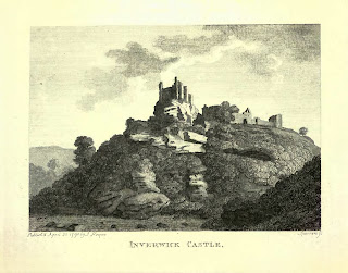
A print of a ruined castle atop a cliff.
Innerwick Castle from ‘The Antiquities of Scotland’


A photo of an overgrown area with a ruined red stone wall sticking out with various empty window spaces in it.  Photo by Kevin Nosferatu for the Skulferatu Project.
View of the ruins of Innerwick Castle


A photo of an overgrown area with a ruined red stone wall sticking out of it.  Photo by Kevin Nosferatu for the Skulferatu Project.
View of the ruins of Innerwick Castle


A photo of an overgrown jumble of red stones that must have once been part of the walls of Innerwick Castle.  Photo by Kevin Nosferatu for the Skulferatu Project.
View of the ruins of Innerwick Castle


A photo of a stone arch that is almost hidden by the green of surrounding trees.  Photo by Kevin Nosferatu for the Skulferatu Project.
View of the ruins of Innerwick Castle


A photo of a stone corridor with an old arched doorway in it.  Photo by Kevin Nosferatu for the Skulferatu Project.
Vaults at Innerwick Castle


A view through a ruined stone doorway into an overgrown area with another doorway in the distance.  Photo by Kevin Nosferatu for the Skulferatu Project.
Vaults at Innerwick Castle


A photo of a tangle of tree branches that almost look like roots.  Photo by Kevin Nosferatu for the Skulferatu Project.
Tree over entrance into the vaults


A photo of a stone walled room with an arched roof and a window at the far end.  Photo by Kevin Nosferatu for the Skulferatu Project.
Vaults at Innerwick Castle


A photo of a small green plant growing in a hole in the wall of the castle.  Photo by Kevin Nosferatu for the Skulferatu Project.
Hole in the wall


A photo of a red stone wall made up of lots of different sized and shaped stones.  Photo by Kevin Nosferatu for the Skulferatu Project.
Stones in the wall


A photo of some faded graffiti on a red stone in the wall.  It shows a smiling sun and the name Gael M.  Photo by Kevin Nosferatu for the Skulferatu Project.
Graffiti on the vault walls


A photo of a large, ruined stone arched room.  There is now no wall at the back and the view out from it is of lots of trees.   Photo by Kevin Nosferatu for the Skulferatu Project.
Vaults at Innerwick Castle


Though much of Innerwick Castle was badly damaged by the attack in 1547, parts of it must have been habitable, as in the 1650s the Covenanters used it as one of their bases from which they harassed and attacked Oliver Cromwell’s troops.  Later, in the 1820s, the castle was home to a local man called Sandy Cowe.  Living there on his own, he grew garden plants in parts of the castle and on its grounds, which he sold around the county.


The ruins of Innerwick Castle have been an inspiration for many artists from the amateur to the well-known.  In 1831, J.M.W. Turner was invited up to Edinburgh to meet up with Sir Walter Scott and his publisher, to discuss his illustrating of Scott’s Poetical Works.  On his way up, after a stop off at Berwick upon Tweed, he spent a couple of days in East Lothian sketching some of the ruined castles there.  One of these castles being Innerwick.  The series of sketches he drew are now held by the Tate.


A sketch of Innerwick Castle sitting on the top of a cliff.
J. M. W. Turner - Innerwick Castle, East Lothian, 1831, Photo © Tate


The land in which the castle sits in is now a nature reserve owned by the Scottish Wildlife Trust.  A steep, narrow, earth trodden path leads up to it, and it was up this path that I trudged on a fine, still day.  Ignoring the sign warning of the dangers of loose masonry, I made my way inside the castle and wandered through what remained of the vaults and once grand rooms.  I took in the views over Thornton Glen and then after my wanderings, left the Skulferatu that had accompanied me, in a gap in the wall of a swirling tower where a stairwell to the upper levels had once stood.


A photo of a small ceramic skull being held up in front of the large, ruined stone arched room.  Photo by Kevin Nosferatu for the Skulferatu Project.
Skulferatu #106


A photo of a wall with an empty window low down and stones paced in the wall where steps would once have been.  In a gap in the wall, almost out of sight, sits a small ceramic skull (Skulferatu 106).  Photo by Kevin Nosferatu for the Skulferatu Project.
Skulferatu #106 in the swirling stairwell tower


A photo of a swirling wall with stones paced in the wall where steps would once have been.  In a gap in the wall, almost out of sight, sits a small ceramic skull (Skulferatu 106).  Photo by Kevin Nosferatu for the Skulferatu Project.
Skulferatu #106 in the swirling stairwell tower


A small ceramic skull (Skulferatu 106) sitting in a gap in a red stone in the wall of Innerwick Castle.  Photo by Kevin Nosferatu for the Skulferatu Project.
Skulferatu #106 in a gap in the wall


TomTom Map showing location of Skulferatu #106
Map showing location of Skulferatu #106


The coordinates for the location of the Skulferatu are –


Latitude 55.955625

Longitude -2.425939


what3words: aimlessly.stealthier.superhero


I used the following sources for information on Innerwick Castle –


Canmore
 
by Francis Grose
1797
 
The Castellated and Domestic Architecture of Scotland from the Twelfth to the Eighteenth Century
Volume Three
by David MacGibbon and Thomas Ross
1889
 
Tudor Tracts 1532 - 1588
Of the Expedition into Scotland by William Patten
1903
 

The Autobiography of a Working Man
1848 
by Alexander Somerville

 
Tate
 

Landscapes of Memory 
Turner as Illustrator to Scott
by Gerald Finley
1980