Just
off North Berwick High Street stands the rather quaint ruin of St Andrew’s
Kirk.This church was built in the 17th
Century and opened on 5 June 1664.It
was built to replace St Andrew’s Old Kirk, which stood near to the sea and had
been so severely damaged by a storm that it had to be abandoned.The ruins of the Old Kirk lie near to the
Scottish Seabird Centre.
With
the arrival of the railway in North Berwick in 1850, the town’s population grew
substantially.By 1873 the congregation was
too large for St Andrew’s Kirk and in 1882 a new and larger church opened nearby.
On
3 June 1883, the last service was held in St Andrew’s Kirk and shortly after
this it was partly dismantled, with various fixtures and fittings being auctioned
off.However, it was decided by the
church authorities to ‘allow the walls of the church to stand in order to form
a picturesque ruin…’
Interior
of the ruins of St Andrew’s Kirk
A view
of the graveyard at Kirk Ports and the ruins of St Andrew’s Kirk
Old
Gravestone at Kirk Ports Graveyard
Carved
skull on one of the old graves
I
placed the Skulferatu that accompanied me on today’s walk around North Berwick
in a gap in the wall at the church.
Skulferatu
#19
Skulferatu
#19 in wall at St Andrew’s Kirk
Google
Map showing location of Skulferatu #19
The
coordinates for the location of the Skulferatu are –
If you drive out of Edinburgh on
Queensferry Road and head towards South Queensferry, the Forth Bridges and Fife,
you pass Corstorphine Hill.From the
road it looks like nothing much, as all you can see is a scruffy area behind an
old stone wall, with bushes and some towering trees.There is no real sense of what lies behind
this.However, if you park up your car
somewhere convenient and walk to the muddy path just off Queensferry Road, you
enter a peaceful woodland haven.Within
a few yards it is hard to believe that just behind you is a noisy, polluted highway.
One of the old quarry sites on Corstorphine Hill
View from Corstorphine Hill of Forth Bridges and hills of Fife
When walking into the woodland from
Queensferry Road, one of the first things you pass is Barnton Quarry.The area is now fenced off.It is a disused, stone quarry that was later
used as a military command centre and nuclear bunker.The bunker was built in 1952 and in the early
1960s was redesigned as a Regional Seat of Government.This meant that in the event of a nuclear war
up to 400 politicians and civil servants could shelter there, while the rest of us fried in the nuclear explosion or died in the
nuclear fallout.The site remained
operational up until the early 1980s.At
the time of writing it is being renovated and converted into a museum and
education centre.
So anyway, I slipped and slid in my
inadequate footwear up through slimy paths of mud and dead leaves.Around me birds sang in the woodland canopy
up above.Then after a bit further
walking, I could see an old, stone tower emerging through the trees.
Scott Tower through the trees
Stairs leading up hill to Scott Tower
This Victorian oddity is the Scott
Tower (also known as Corstorphine Tower or Clermiston Tower) and was built in
1871 to commemorate the centenary of the birth of Sir Walter Scott.A bit greedy you might think, considering
that there was already the Scott Monument in central Edinburgh to celebrate his
life.However nowadays it is hard to
comprehend the fame of this Edinburgh born novelist, poet, playwright and
historian.The man’s novels were
international bestsellers.In fact, it
was said that some of his novels outsold the Bible, which at that time was quite
something.Nowadays his work, to the
modern reader, seems very turgid and boring.I did try to read his novel Waverley once for a university course, but soon
gave up and did the work on a novel by Daniel Defoe instead.Moll Flanders – a much easier read.
Scott Tower, Corstorphine Hill, Edinburgh
Scott Tower through the trees
Scott Tower is situated at the top of
Corstorphine Hill and is twenty metres tall.It is usually locked, but pre-Covid was open occasionally to the public.I’ve never managed to get to it when it has
been open, but have been told that the views from it are quite amazing.One day I will get up there and take a few
photos.
Today’s Skulferatu was left in a hollow
in a tree not far from the entrance to the tower.
Skulferatu #10
Skulferatu #10 left in hollow in tree
Google Map showing location of Skulferatu #10
The coordinates for the location of the
Skulferatu are: Latitude 55.951069Longitude -3.272677.
I have many fond memories of Calton
Hill and days of misspent youth there.On a cold, February morning in 1982 the kid’s TV programme Swap Shop was live on the hill in front of the National Monument.I have a memory of the main stage being a boxing ring, not metaphorically, but it literally was an actual boxing ring.We then had the excitement of watching the Revillos mime to their song ‘Bongo Brain.’There is an extremely lo-fi and wobbly video of this available on YouTube.
The Revillos on Swap Shop at Calton Hill, Edinburgh
In the summers of the mid 1980s my friends and I used to go up the hill and sit by the pillars of the National Monument of Scotland (or Edinburgh’s Disgrace, as we knew it).There we’d smoke fags and drink cheap, nasty lager and think we were cool.We were not cool, but rather just a bunch of slightly pissed and noisy teenage geeks.
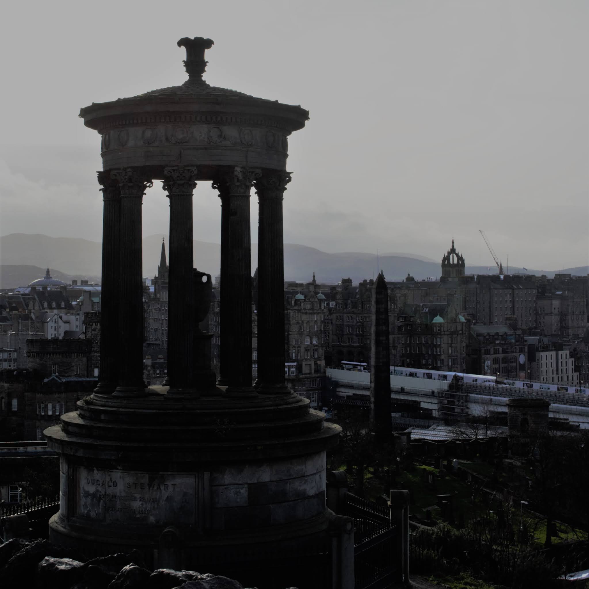
Other than the National Monument,
Calton Hill is cluttered with exciting, old buildings such as the Dugald
Stewart Monument, the Old Observatory House, the City Observatory, and Nelson’s
Monument.It also has some spectacular
views over Edinburgh.
View from Calton Hill over Edinburgh to Leith
A brief history of the main buildings is –
The National Monument of Scotland was
built to commemorate the Scottish soldiers and sailors who died in the Napoleonic
Wars.It is modelled on the Parthenon in
Athens and work began on it in 1826.However,
by 1829 the money for its construction had run out and it was left unfinished.
The National Monument of Scotland or Scotland's Disgrace
The Dugald Stewart Monument is a memorial
to the Scottish Philosopher and mathematician Dugald Stewart (1753-1828).Regarded as an important figure in the Scottish
Enlightenment he published many philosophical essays.Here’s a little quote from him – ‘There are
very few original thinkers in the world, or ever have been; the greatest part
of those who are called philosophers, have adopted the opinions of some who
went before them.’
The Dugald Stewart Memorial
The Old Observatory House was designed
by the architect James Craig and was originally built as a family home.It was then used by astronomers for a short
time.It is now rented out as holiday accommodation.
The City Observatory was built in 1818 and
was used until 1896 when due to light pollution from the city centre, it was
decided to move to the Royal Observatory at Blackford Hill.
Nelson’s Monument was built between
1807 and 1816 to commemorate Vice Admiral Horatio Nelson’s victory over the
French and Spanish Fleets at the Battle of Trafalgar in 1805, and his death
during the same battle.In 1852 a
mechanised time ball was added that was synchronised with the one o’clock gun
fired daily from Edinburgh Castle.The
time ball dropped daily allowing ships in Leith Harbour to set their
chronometers by it.
Nelson's Monument
I left the Skulferatu, that came on my
walk in a gap in a tree, just on the hill leading up to
Nelson’s Monument.
Skulferatu #9
Skulferatu #9 in split in tree
The coordinates for the location of the
Skulferatu are: Latitude 55.954352 Longitude -3.182646.
I remember this church from my
childhood, as I walked out to it a few times with my Grandpa.He worked in one of the nearby villages and
would check on the church every so often to make sure all was in order.Back then the key was kept above the main
door so that anyone passing by could pop in to shelter or pray.Useful when it was pouring with rain
outside.As a kid I was always
fascinated by the two barred windows at the back of the church.Sitting at ground level these windows gave a
view into the crypts below, where on a good day, if you got your head into just
the right position you could see some of the coffins inside.Grandpa always said he would get hold of the
keys for the crypt and show us down there, but never did.No doubt if he had I would have been
disappointed, as I was hoping to see stacks of skeletons everywhere rather than
just and a few more crumbling coffins.
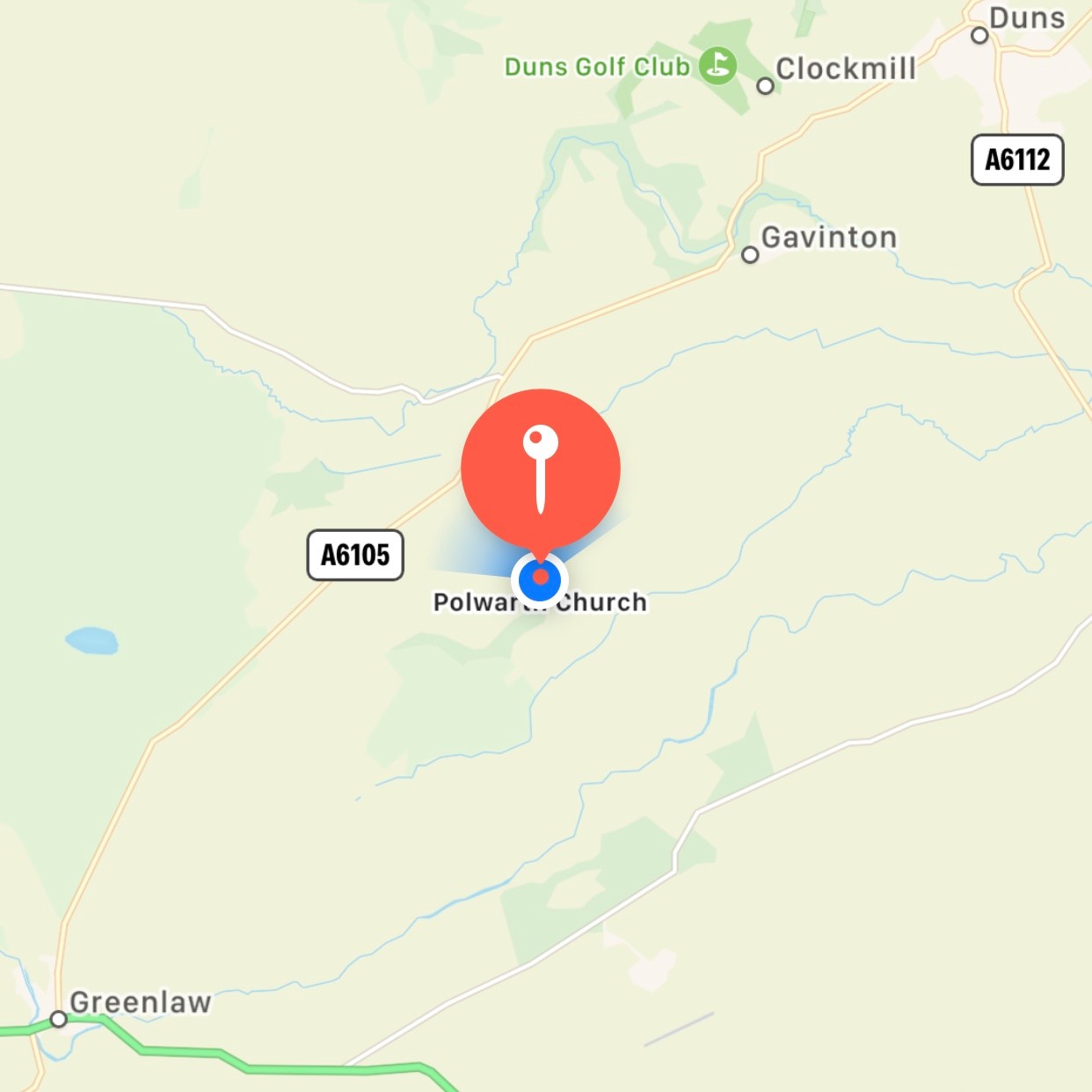
The first records of Polwarth Church
are from 1242 when the Bishop of St Andrews, David de Bernham, consecrated the
church and dedicated it to St Mungo.The
church was almost completely rebuilt in 1703.
In 1683, Sir Patrick Hume hid for four
weeks in the crypt at the church after being implicated in the Rye House Plot.
This was a plot to assassinate King Charles II and his brother.His daughter, Grizel (Lady Grizel Baillie),
smuggled him food while he was in hiding.Hume and his family then fled to the Netherlands only returning to
Scotland after the Glorious Revolution when King William of Orange took the
crown in both England and Scotland.
The church closed in 2004 and was sold
off by the Church of Scotland.It is now
privately owned.
Front view of Polwarth Church
Gravestone in the Churchyard
View of two coffins in the crypt
The Berwickshire poet, Robert McLean
Calder (1841 to 1895) wrote a poem about the church and its congregation.It is far too long and a little bit dull to
quote in full, so here is one verse for your delectation –
There are many lovely walks around the coast of East Lothian. One of these takes you from Dunbar and round to
Torness Nuclear Power Station and beyond.This walk takes you past Barns Ness Lighthouse, which sits just up from
the sea on a large expanse of Marram Grass.
Barns Ness Lighthouse
Barns Ness Lighthouse and Cottage
The lighthouse was designed by two of
the Lighthouse Stevensons, the brothers David and Charles Stevenson (both
cousins of the author Robert Louis Stevenson).
It was constructed between 1899 and 1901 and was manned by two
lighthouse keepers until 1966, when it was electrified. Only a single keeper was then required. The lighthouse was fully automated in 1986
and after a review of lighthouses, was deactivated in 2005. It was sold in 2006 and the lighthouse
cottage is now a holiday rental.
During the Second World War the
lighthouse was machine gunned by a passing German plane, however it was not
damaged by this.
A view of the lighthouse
I walked out to the lighthouse from
Dunbar on a cold and sunny afternoon. The sky was
a pale blue with white and grey clouds skiffing through it, while the sea
was a still and calm blue black. All the
colours of winter coming into their own.
Skulferatu
#5
Skulferatu left at base of lighthouse tower
I left a Skulferatu at the base of the
lighthouse where if faces out to the sea.
Google Map showing location of Skulferatu
The coordinates for the location of the
Skulferatu are –
I walked out from Leith to the Eastern Breakwater
at Granton Harbour. I took the path along the
Water of Leith and then went down Trinity Path and on to Lower Granton Road, where I followed the coastline along to Wardie Bay.The sun was out, but the wind was a raging
howl. The clouds above me zoomed over the sky, as if they were making up for the lack of aircraft in these Covid riddled times. The tide was high, and the air
tasted of the salt spray from the water.
Granton
Eastern Breakwater from Wardie Bay
The walk along the Eastern Breakwater is
one I only discovered recently, as though I’ve passed it many times on the bus,
I had always assumed it would be closed to the public.Given that its rather exposed and the walk is
a bit uneven, it will probably be closed for ‘health and safety’ reasons at some
point in the future!
The harbour at Granton consists of three parts, the main harbour, Granton Harbour Breakwater and the Eastern Breakwater. The main harbour is now mainly used by
leisure craft and the Royal Forth Yacht Club is based there, the Granton Harbour Breakwater is closed off due to construction in that area, while the Eastern
Breakwater is a popular spot with local fishermen.However, the harbour once had a busy and industrious
past.It opened in 1838 and the
construction was funded by the 5th Duke of Buccleuch.The lighthouse engineer, Robert Stevenson (grandfather
of the famous author Robert Louis Stevenson) then oversaw the construction of the
outer breakwaters.These were completed
in 1863.The harbour became a port for
the export of coal, the import of esparto grass, used in making paper, and a
large fishing fleet was also resident there.
In 1847 the Edinburgh and Northern
Railway operated a ferry service from Granton Harbour to Burntisland in Fife.In 1850 they opened the first roll-on-roll-off
railway ferry in the world and this allowed a direct rail link from Edinburgh
to Dundee without passengers having to leave the train.This service ended in 1890 with the opening
of the Forth Bridge.
Warning sign at entrance to Eastern Breakwater
On the Eastern Breakwater I was blasted by the wind as I carefully made my way
along the walkway. There is a narrow
walkway on either side of the jutting, uneven stones that make up the main part
of the structure.Here and there are
rusting moorings and chains and there are a couple of small, crumbling
buildings.The buildings are both now
sealed, but up until recently were open.There was little in them other than discarded beer cans, fishing line and
the smell of stale piss.
View along Eastern Breakwater
One of the buildings on Eastern Breakwater
At the end of the Breakwater I reached a white, box structure.I don’t have a clue what this is, but assume
it was a lighthouse of sorts at one point.There I found a circular hole in the wall which was a perfect place to
leave a Skulferatu.So, I left one
there.
End of the pier – Eastern Breakwater
Skulferatu
#4
Skulferatu #4 in hole in wall in lighthouse
I then struggled back along towards the shore as the wind tried to whip my
feet away from me and the low winter sun dazzled my eyes.Overhead seagulls soared and screeched their
eerie calls to one another.
Map showing location of Skulferatu
The
coordinates for the location of the Skulferatu are –
My
Covid reading for the last few weeks has been ‘I, Claudius’ and ‘Claudius the
God’ by Robert Graves.So, immersed in
stories of ancient Rome and the Emperor who conquered a large part of Britain, I
thought I’d take a walk out to Eagle Rock.As a child, one of my friend’s and I had often played on the beach, in the
area of the rock.The Historic Scotland
plaque pointing out the eagle was not in place at the time and we hadn’t really noticed or paid any attention
to the carving on the rock.Then one day
my friend’s dad pointed out the eagle and told us it dated from the time of the
Romans. The rock then sort of took on a
magical significance, imbued with all that ancient history, and we would often imagine ourselves as Roman legionnaires in a foreign and hostile land.
Eagle
Rock
The
eagle on Eagle Rock is a very worn carving, which is thought to date from
around AD 140 to the early AD 200s.At
this time, the Romans occupied nearby Cramond and had a fort there.It is unclear whether the eagle was a piece
of Roman graffiti art or if it had any religious significance.
The
worn carving of the eagle and Historic Scotland Plaque
To
get to the rock I walked through Cramond and then over the old bridge which
took me on to the road to Lord Rosebery’s estate.On the estate there is a well-worn path that follows
the coast around to South Queensferry.Despite it being a warm day with the sun out, the path was a muddy
sludge from the recent rain.So,
slipping and sliding I made my way down to the short stretch of beach by Eagle
Rock. Overhead a single plane flew, its wheels down and engine roaring as it came into land at nearby Edinburgh Airport. A reminder of the time before Covid when planes would be roaring overhead every few minutes as they came into land or were taking off.
View
of Eagle Rock looking over the Forth to Fife
On the beach the tide was out and some kids played while their parents laid out a picnic on a battered looking old rug. They waved hello as I walked past them and along to Eagle Rock. There, I walked around and took a few photos before looking for a suitable place to leave the Skulferatu.There was a nice, pocked ledge below the
eagle, so I left it there and walked off to rejoin the path and make my way home.
Skulferatu
#3
Skulferatu
#3 in situ
The coordinates for the location of the
Skulferatu are –