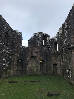
Morton Castle is not the easiest place to find, which despite being a pain in the arse, actually adds to its charm and also to a sense of it being in a more remote and undiscovered location. On our trip there our Sat Nav took us to a row of houses and told us we had reached our destination. We were in fact still a couple of kilometres away, and it wasn’t until driving a bit further on and having checked the various map apps on our phones that we managed to find where we wanted to go. A narrow, winding, single track road then led us to a small parking area. From there it was a short walk down the path of the Morton Heritage and Nature Trail to the ruins of the castle.
The ruins of Morton Castle stand on the south
west slopes of the Lowther Hills and overlook Morton Loch. The castle was originally a two storeyed hall
block with a four storey turreted gatehouse at the west end of the building and
an angle tower at the east end. The
lower storey of the building would have consisted of a kitchen, a storage area,
and a lower hall, while the first floor would have housed the great hall. The private chambers of the lord of the
castle and his family would have been in the tower at the east of the building.
The site on which the castle sits is
thought to have been where a stronghold was built by Dunegal, Lord of Nithsdale
in the Twelfth Century. These lands were
later granted to Thomas Randolph, the nephew of King Robert I. The castle itself is believed to have been
built in the early Fourteenth Century and was mentioned in 1357 in a treaty
with England to release King David II from captivity. The treaty called for the demolition of
several castles in South West Scotland, Morton Castle being one of them. It is unclear how much of the castle was demolished
at that time.
In 1372 the castle and the lands around
it were passed through marriage to the Douglas family, who later became Earls
of Morton. It is believed that parts of the
castle were rebuilt in the early Fifteenth Century. The castle was then leased out to another
branch of the Douglas family, though does not seem to have been their primary
residence and may have been used mainly as a hunting lodge. It appears that it later fell into disuse and
by 1714 was abandoned. Much of the stone
was then taken away and used for constructing farm buildings. The castle was acquired by the Duke of
Queensberry and was later passed down to the Dukes of Buccleuch. It then passed into state care under a
guardianship agreement in 1975.
I left the Skulferatu that accompanied
me on my trip in a crack in one of the outside walls of the castle.
The coordinates for the location of the Skulferatu
are –
Latitude 55.274466
Longitude -3.747266
I used the following sources for information on Morton Castle –
Historic Environment
Scotland – Statement of Significance Morton Castle
Morton Castle Statement
of Significance
Canmore – Morton Castle
Information Boards at
Site
The Castellated and
Domestic Architecture of Scotland from the Twelfth to the Eighteenth Century
By David MacGibbon and
Thomas Ross
1886


