Tuesday, 4 January 2022

Skulferatu #55 - Graveyard at Parish Church of Penpont, Keir and Tynron, Penpont, Dumfries and Galloway


Penpont is a small village in Dumfries and Galloway.  It was once an important staging post for travellers, and on the main street it has a tearoom and gallery that is still a popular stopping off point for cyclists, ramblers, locals, and tourists.


The man who may have invented the bicycle, Kirkpatrick Macmillan, lived a short distance from Penpont, and Joseph Thomson, the explorer who gave his name to Thomson’s Gazelle, was born in the village.


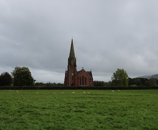
The Parish Church of Penpont, dominates the skyline of the village, and stands on a low hill above the Scaur Water.  It was designed by Charles Howitt and built in 1867 to replace the church that originally stood on the site.  The design of the church is a large cruciform in the Gothic style, with a tall tower and spire in the north-east corner.  It was constructed using local pink sandstone.


A photograph showing a view over a field to a church with a very tall spire in comparison to the building.  This is the Parish Church of Penpont, Keir and Tynron.  Photo by Kevin Nosferatu for the Skulferatu Project.
The Parish Church of Penpont


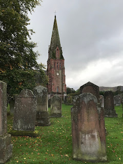
The gravestones in the graveyard date mainly from the 17th to 18th centuries, though there were some that dated from the 11th and 12th centuries.  These, however, were removed and are now in Dumfries Museum.  Among those buried in the graveyard is John Ross, a soldier who fought at the battle of Waterloo defending the Quarte Bras Farmhouse. 


A photograph of several old and worn gravestones in Penpont Churchyard, with the Parish Church in the background.
Gravestones in Penpont Churchyard


A black and white photograph showing a detail of a memorial in Penpont Churchyard.  It is of a carved skull and crossbones, amongst other decorative images on worn stone.
Detail of memorial in Penpont Churchyard


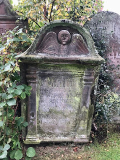
A photograph of a red stone grave with a carving at the top of a face and wings.  The grave is of a man named Samuel Hislop.
Grave of Samuel Hislop


A photograph of an old gravestone in Penpont Graveyard.  At the top is carved a round face with wings underneath.  The writing on the stone is illegible.
Gravestone at Penpont Churchyard


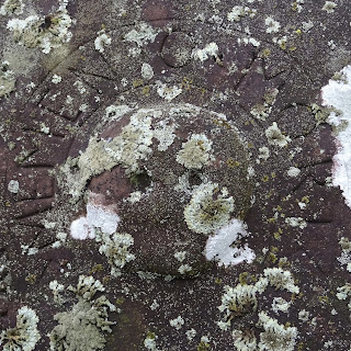
A photograph of a faded, carving of a round style skull on a gravestone.  The stone is covered in lichen and Memento Mori is carved around the skull.
Memento Mori – detail from a gravestone


A photograph of a gravestone in Penpont Graveyard.  It ists next to a fence of iron railings on which is attached a homemade sign reading - Please do not drive over graves thank you.
Please Do Not Drive Over Graves Thank You


A photograph of an old gravestone at Penpont Churchyard.  Carved on it is a head with wings underneath and below that an hourglass lying on its side as if to signify that time is up.
Gravestone at Penpont Churchyard


A photo of a table top style gravestone.  The photo shows the bottom end of the stone and the legs, between which is carved a head with wings underneath.  The gravestone is very worn.
Gravestone of Patrick Boyle


I left the Skulferatu that accompanied me on my walk in the shelter underneath a table top gravestone.  The engraving on the gravestone was badly worn, but it appeared to be the grave of one Patrick Boyle, who had died in the 1790s.  In the gap underneath there were bits of old, broken pottery, some spiders, and the lower branches of a nearby holly bush.  My Skulferatu joined them there.


A photo of a hand holding up a small, ceramic skull with the lower part of Penpont Parish Church in the background.  Skulferatu #55
Skulferatu #55


A photo of a small, ceramic skull (Skulferatu 55 lying in a grassy patch underneath one of the gravestones.  There is some old, broken pottery near to it.
Skulferatu #55 under Patrick Boyle’s gravestone


Google Map showing location of Skulferatu #55 near to the Parish Church of Penpont, Keir and Tynron.
Map showing location of Skulferatu #55


The coordinates for the location of the Skulferatu are –


Latitude 55.231176

Longitude -3.811273


I used the following sources for information –


Scotland’s Churches Trust

Penpont, Keir and Tynron Church


Penpont Heritage Centre
Penpont Heritage Centre

No comments:

Post a Comment