Tuesday, 30 July 2024

Skulferatu #124 - Segedunum Roman Fort, Wallsend, Tyne and Wear


When I’m down in Newcastle, I like to zoom round to various places on the Metro and then have a wander around them.  On my latest visit I decided to go to Wallsend, a town I don’t think I’ve visited since the early 1970s, when I was just a wee sprog.  Since I was last there the remains of a Roman Fort have been uncovered, so I headed off to that.


Segedunum is the name of the Roman Fort, and it sits at the eastern end of Hadrian’s Wall in Wallsend.  And those of you with a quick mind, unlike me, will realise that the town of Wallsend takes its name from being at the walls end. 


The building of Hadrian’s Wall was started in AD 122, when the Roman Emperor, Hadrian came to inspect one of the far flung lands of his empire.  While he was here, it was decided that a wall should be built to protect the Romans from the Barbarians in the North.  So, those nifty little Romans built a great big wall that ran from Wallsend to Bowness-on-Solway in Cumbria.  A wall that was around 73 miles (117.5 kilometres) long, or 80 Roman miles long, their measurement of a mile being slightly shorter than ours.


A photo of a rust red iron statue of a Roman Centurion.  Behind it is a red brick building with a flat roof.  Photo by Kevin Nosferatu for the Skulferatu Project.
Sentius Tectonicus – sculpture by John O’Rourke


A view over a flat and fenced off piece of land on which can be seen some square areas of stone.  Photo by Kevin Nosferatu for the Skulferatu Project.
View over the site from the museum viewing tower


A view over an area of flat land with a white building with a red tiled roof standing on the left, this is the reconstructed bath house.  Photo by Kevin Nosferatu for the Skulferatu Project.
View over the site from the museum viewing tower


The fort at Segedunum was built at around the time the wall was being constructed, and was in use for around three hundred years, up until around 400 AD. It sat on a plateau overlooking the River Tyne with a commanding view of a mile or two, up and down the river.  Within the fort there were barracks for the infantry and cavalry, a headquarters building, a house for the commanding officer, a hospital, and various other buildings.  A high defensive parapet wall surrounded the fort with a walkway running around it.  There were also several observational towers along the wall to keep an eye out for any of those pesky barbarians. 


Outside the fort, evidence has been found that there was a large village along with a temple complex and a bathhouse.  The village stretched all the way down to the river where it is likely there would have been some sort of harbour.  In the village dwelled various craftsmen and tradesman from local areas and further afield, who made their living trading with the soldiers based in the fort. 


A photo of a white building with a red tiled roof - the reconstructed Roman bath house.  Photo by Kevin Nosferatu for the Skulferatu Project.
The Bath House


A view over a flat piece of land with various shapes marked out on it.  In the background is a building with a tower and a viewing room on it - the museum.  Photo by Kevin Nosferatu for the Skulferatu Project.
View over the fort site to the museum


A photo of a carboard Roman soldier standing on the stony ground of the Segedunum site.  Photo by Kevin Nosferatu for the Skulferatu Project.
Last man standing


A photo showing two square areas in the ground full of pebbles.  In the distance is a row of red brick buildings.  Photo by Kevin Nosferatu for the Skulferatu Project.
View over the fort site


A photo of a stone drain with a flat rock covering a part of it.  Photo by Kevin Nosferatu for the Skulferatu Project.
Romans pooped here


A view of marked out areas full of pebbles, used to show where the buildings of the fort at Segedunum once stood.  Photo by Kevin Nosferatu for the Skulferatu Project.
View towards the Bath House


In AD 409, Britain was basically dumped by Emperor Honorius, who had bigger problems to deal with as the Roman Empire began to collapse around him.  It appears that the fort was abandoned at some point around then, and much of the stone from it was taken away to be used for other buildings.


The fort and the area around it then became farmland for many years, before Wallsend Colliery was established nearby, and housing was built over where the fort had stood.  Excavations were carried out on the site at various times and then in the 1990s a major project was undertaken to turn it into a visitor attraction.  Now, sitting by the fort there is a museum with a viewing tower that overlooks the site, and opposite that a reconstruction of a Roman bath house.   


While wandering around the museum, I introduced my Skulferatu to one of the exhibits there, a replica skull grinning out at the visitors.  The replica was of a skull found with a healing sword wound in it.  Hmm, that must have hurt.


A photo of a human skull.  Photo by Kevin Nosferatu for the Skulferatu Project.
A winning smile


After walking around the remains and outlines of the fort at Segedunum, I left the Skulferatu that had accompanied me in amongst the stones marking the cavalry barracks.


A photo of a flat area of land with a circle marked out in it.  Photo by Kevin Nosferatu for the Skulferatu Project.
Site of the cavalry barracks


A photo showing a small ceramic skull (Skulferatu 124) being held up with the museum viewing tower in the background.  Photo by Kevin Nosferatu for the Skulferatu Project.
Skulferatu #124


A photo showing a small ceramic skull (Skulferatu 124) lying amongst pebbles and boulders.  Photo by Kevin Nosferatu for the Skulferatu Project.
Skulferatu #124 in amongst the stones


A close-up photo showing a small ceramic skull (Skulferatu 124) lying amongst pebbles and boulders.  Photo by Kevin Nosferatu for the Skulferatu Project.
Skulferatu #124 in amongst the stones


TomTom Map showing the location of Skulferatu #124
Map showing the location of Skulferatu #124


The coordinates for the location of the Skulferatu are -

 
Latitude 54.987535

Longitude -1.532107

 
what3words: hotels.move.page


I used the following sources for information on Segedunum –

 
Tourist info at the site
 
Segedunum booklet – available from the museum


Tuesday, 9 July 2024

Skulferatu #123 - Lochore Castle, Glencraig, Fife


Needing somewhere new to explore, I headed off to the deepest, darkest depths of Fife, where I visited a castle so ruined that it is barely more than some tall toothy stumps of walls jutting out of the ground.  Not to disparage this castle, as I think that out of all the various castles I’ve visited in my lifetime, my favourites have all been the ones crumbling into rubble.


After taking a train to Lochgelly, I walked down to Lochore Meadows Country Park where, near to the entrance, Lochore Castle stands.  The park, now a tranquil place of lochside walks, trees, and bird song, was once a hive of industry with a colliery, a railway and all the heavy industry associated with coal mining.  All of that is now long gone, with only the winding tower of the mine standing as a monument to its industrial past.  


Lochore Castle originally stood on the intriguingly named island of Inchgall, the Island of Strangers, on Loch Ore.  While the castle still stands where it always stood, the island it stood on is an island no more, after the loch around it was drained in the 1790s.  Confusingly, the loch is now back, though not quite in the same place it used to be.  Get your head around that one.


A photo of the ruined walls of a castle sitting on a slight hill.  Photograph by Kevin Nosferatu for the Skulferatu Project.
Lochore Castle


A view of two tall stumps of wall and a lower wall, all on a slight incline.  Two people are walking down from the walls.  Photograph by Kevin Nosferatu for the Skulferatu Project.
The ruins of Lochore Castle


A view up a grassy hill to the ruined walls of Lochore Castle.  Photograph by Kevin Nosferatu for the Skulferatu Project.
The ruins of Lochore Castle


A view through the centre of the four stumps of the walls of Lochore Castle.  Photograph by Kevin Nosferatu for the Skulferatu Project.
The ruined walls of Lochore Castle


On arriving at the castle, I wandered around and through what remained of it.   The whole middle section of the main tower has now gone, leaving only some of the thick outer walls.  Sitting on the top of these were the brittle and dead remains of plants from last summer.  Once green and bright with flowers reaching up to the warmth of the sun, they were now brown stems and seed husks that swayed lifelessly in the gentle afternoon breeze. As I walked out and round the outer walls my feet crunched through the strimmed remains of dead bramble bushes, and I had to shield my eyes from the low, bright, and blinding winter sun.  Jutting out from one of the walls was a tree stump.  In the dead wood and twisted knots, I found what looked to me like a surprised face peering from the distant past out onto our ‘modern’ world.  I waved hello and walked on by. 


Inside the castle ruins


A view of a crumbling stump of the stone walls of Lochore Castle.  Photograph by Kevin Nosferatu for the Skulferatu Project.
A crumbling stump of the castle walls


A view looking up from a lower wall to the crumbling walls of Lochore Castle.  There are shadows from the surrounding trees at angles to the walls.  Photograph by Kevin Nosferatu for the Skulferatu Project.
The ruins of Lochore Castle


A view of a tree stump sitting in the wall outside Lochore Castle.  Photograph by Kevin Nosferatu for the Skulferatu Project.
A tree stump in the walls of the castle


A photo showing curves and knots in the tree stump that look like a human face peering out at the viewer.  Photograph by Kevin Nosferatu for the Skulferatu Project.
A face in the tree stump


It is believed that there was a castle on this site from around the Twelfth Century, this having probably been built for Robert the Burgundian.  He appears to have been a French knight who was granted the lands around Loch Ore, and an excavation at the castle in 2015 found pieces of Medieval French pottery.  Robert’s family then appear to have taken on the Lochore name and in 1291 the castle and lands around were owned by Constantine de Lochore.  Constantine was the Sheriff of Fife, and a man of changing loyalties.  He originally swore allegiance to the English king, Edward I, but then changed his mind and joined William Wallace to fight in the war for Scottish Independence.  After being captured and held prisoner for a time, he again swore allegiance to Edward and was allowed to return back to Fife.


A black and white photo looking up from the long dead grass on the hill to the V shaped wall of part of Lochore Castle.  Photograph by Kevin Nosferatu for the Skulferatu Project.
The ruins of Lochore Castle


In the Fifteenth Century the castle passed into the hands of the Wardlaws of Torry, and much of it was rebuilt for Robert Wardlaw.  The castle was described at that time as being a ‘strong square tower, with many lower buildings, surrounded by a wall, with round towers’ and that it was ‘washed by the waters of the Loch, which abound with pike and perch.’ It was also said to be one of the strongest castles in Fife.


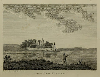
An old illustration showing the figure of a man casting his fishing road into a large body of water.  In the centre of the water is a small island with a ruined castle sitting on it.
Loch Orr Castle – illustration from The Antiquities of Scotland


 An illustration showing a ruined castle sitting on a small hill with several trees in the foreground.
Loch Ore Castle - illustration from The Castellated and Domestic Architecture of Scotland


At some point in the Eighteenth Century the castle was abandoned, and it fell into ruin.  In 1938 there were calls for the remains to be demolished, as they were seen by some to be dangerous due to subsidence in the area caused by mining.  The local council found that they did not have the powers to order the demolition, and luckily the owner of the land was unwilling to do so.  The castle ruins are now seen as being of special interest, given that it was probably one of the earliest castles built in Fife.


After my wander around the ruins, I left the Skulferatu that had accompanied me in a gap in the crumbling cement of the walls.


A photo showing a small, ceramic skull (Skulferatu #123) being held up with the ruins of Lochore Castle in the background.  Photograph by Kevin Nosferatu for the Skulferatu Project.
Skulferatu #123


A close-up photo showing a small, ceramic skull (Skulferatu #123) sitting in a gap in a stone wall.  A photo showing a small, ceramic skull (Skulferatu #123) sitting in a gap in a stone wall.  Photograph by Kevin Nosferatu for the Skulferatu Project.
Skulferatu #123 in in a gap in the crumbling cement


Photograph by Kevin Nosferatu for the Skulferatu Project.
Skulferatu #123 in in a gap in the crumbling cement


Google Map showing the location of Skulferatu #123
Map showing the location of Skulferatu #123


The coordinates for the location of the Skulferatu are -


Latitude 56.148461
Longitude -3.329002

what3words: hammocks.unroll.winters


I used the following sources for information on Lochore Castle –

 
The Antiquities of Scotland, Vol 2
by Francis Grose
1797
 
The Castellated and Domestic Architecture of Scotland from the Twelfth to the Eighteenth Century, Volume Three
By David MacGibbon and Thomas Ross
1889
 
Dundee Courier - Saturday 29 September 1906
 
Dundee Evening Telegraph - Thursday 15 December 1938