Showing posts with label Fife. Show all posts

Tuesday, 19 August 2025

Skulferatu #139 - Macduff's Castle, East Wemyss, Kirkcaldy, Fife


After taking a trip to the Wemyss Caves, I made my way around and up to the hill above them. On top of this hill, there sits a ruinous and crumbling tower, this is all that remains of Macduff’s Castle.  This Castle has traditionally been associated with the Eleventh Century Thane of Fife, Macduff, and was the setting of a very famous fictional murder.  It was here that Shakespeare had the evil assassins, sent by Macbeth, brutally murder Macduff’s wife and children. Of course, Shakespeare made all of this up and none of it actually happened, and though it was believed the Thane of Fife had a fortification somewhere around the area, it is not known where.  


A wooden model of a castle with a low wall around it and two small bushes growing inside the wall.  In the distance behind the model castle is a modern housing estate.  Photograph by Kevin Nosferatu for the Skulferatu Project.
A model of how Macduff’s Castle may have looked


A sketch of the ruins of Macduff's Castle showing two towers with a building in the middle and a low wall surrounding the building.  Sketch taken from The Castellated and Domestic Architecture of Scotland from the Twelfth to the Eighteenth Century, Volume 4 by David MacGibbon and Thomas Ross.
Sketch of the ruins of Macduff’s Castle circa 1892


The earliest part of the castle that stands here now was built in the Fourteenth Century by the Wemyss family, who were descendants of the Macduff’s.  Later buildings were added in the fifteenth and Sixteenth centuries and the castle ended up consisting of two towers connected by a gatehouse sitting between them.  As with many castles, Macduff’s castle was owned over time by several families who added some buildings and modified others. Then in 1630 it was bought back by the Wemyss family.  The last records of it being in use was in 1666 when Lady Jean Wemyss, Countess of Sutherland, sent her children to live there as she was worried that the plague ravaging parts of England would reach Edinburgh.  It didn’t.  At some point after this the castle was abandoned and fell into decay and ruin.  Up until 1967, two of the castle’s towers still stood, but then fearing for the safety of children playing around the ruins, Fife Council had the eastern tower demolished.  Then, in the 1970s a Dovecote that had stood on the shore down from the castle was destroyed by the sea. What remains of the castle is crumbling and cracked with much hidden in deep undergrowth.  It is however now a Scheduled Ancient Monument.


A photo of the ruin of a red stoned tower building jutting out from bushed and trees.  Photograph by Kevin Nosferatu for the Skulferatu Project.
The ruins of Macduff’s Castle


A closer view of the red stone tower.  Most of the front wall has gone.  Photograph by Kevin Nosferatu for the Skulferatu Project.
The ruins of Macduff’s Castle


Macduff’s Castle, like all good castles, has tales of a ghost wandering its empty ruins.  Known locally as the Grey Lady, she is said to be the ghost of Mary Sibbald.  The story goes that she was a servant girl at the castle who was accused of theft.  At her trial she vehemently denied the charges, but was found guilty and sentenced to be publicly flogged.  The executioner who carried out the flogging was a cruel man, and so severely did he strike her that she died a few days later of her injuries.  Ever since, she has wandered the castle and its grounds silently protesting her innocence to anyone who may see her.


* * *


Ignoring the danger to life signs, I pushed myself through bushes and undergrowth and made my way around the castle. 


A view of the weather worn ruins of the tower building.  On the wall can be seen the marks left where the roof of the gatehouse was at one time.  Photograph by Kevin Nosferatu for the Skulferatu Project.
Ruins of Macduff’s Castle


A view of a round tower on rectangular building.  Both are ruined with cracks running down the stone walls.  There are slit windows in the tower.  Photograph by Kevin Nosferatu for the Skulferatu Project.
Macduff’s Castle rising up from the undergrowth


A round stone tower jutting out from undergrowth and a tree.  The tower has two slit windows in it.  Photograph by Kevin Nosferatu for the Skulferatu Project.
Tower at MacDuff’s Castle


A view looking over fields of ripened corn with a few trees scattered here and there.  In the distance can be seen the sea.  Photograph by Kevin Nosferatu for the Skulferatu Project.
View from Macduff’s Castle


At the back there was an entrance of crumbling stone into what I assume was a cellar.  Inside it was damp and dank with a floor littered with cans, bottles and a condom or two.  Lovely.  Leaving the cellar and cutting around, I made my way to the main part of the remaining tower and clambered up onto the crumbling stage like floor. 


A view inside the ruined red stone building.  There is a barred doorway with an empty window up in the wall above it.  A huge crack runs down one of the walls.  Photograph by Kevin Nosferatu for the Skulferatu Project.
The crumbling ruins of the castle


A view of the tower stairwell and spiral staircase.  On one side are the stairs going up and there is a slit window there.  On the other side are the stairs going down.  Photograph by Kevin Nosferatu for the Skulferatu Project.
The tower stairwell


A view of a wall in which there is an opening that looks a bit like a mouth while up above are two holes that look like eyes.  The holes are probably a fireplace and where the supports for the floor above would have been.  Photograph by Kevin Nosferatu for the Skulferatu Project.
A fireplace, maybe?


A wall of weather worn red stone - some of the stones have deep holes and pit marks in them.  Photograph by Kevin Nosferatu for the Skulferatu Project.
Weather worn stones of the castle


Inside Macduff’s Castle


The place was a perfect setting for a performance of Macbeth, and I could almost imagine the arrival of the assassins –


Lady Macduff: (On being told by a messenger she should flee the castle)

Whither should I fly?
I have done no harm. But I remember now
I am in this earthly world, where to do harmed
Is often laudable, to do good sometime
Accounted dangerous folly. Why then, alas,
Do I put up that womanly defence
To say I have done no harm?


(Enter Murderers)


Lady Macduff:

What are these faces?


Murderer: 

Where is your husband?


Lady Macduff:

I hope in no place so unsanctified
Where such as thou mayst find him.


Murderer:

He’s a traitor.


Macduff’s Son:

Thou liest, thou shag-eared villain!


Murderer:

What, you egg?
(Stabbing him) Young fry of treachery!


Macduff’s Son:

He has killed
me, mother.
Run away, I pray you.  (Dies)


(Exit Lady Macduff crying - Murder!)


* * *


Before leaving the castle, I left the Skulferatu that had accompanied me in a hole in the wall of the tower.


A photo of a small ceramic skull (Skulferatu 139) being held up with the ruins of Macduff's Castle in the background.  Photograph by Kevin Nosferatu for the Skulferatu Project.
Skulferatu #139


A photo of a small ceramic skull (Skulferatu 139) in a hollow in a red stone wall.  Photograph by Kevin Nosferatu for the Skulferatu Project.
Skulferatu #139 in a hole in the wall of the castle tower


A close-up photo of a small ceramic skull (Skulferatu 139) in a hollow in a red stone wall.  Photograph by Kevin Nosferatu for the Skulferatu Project.
Skulferatu #139 in a hole in the wall of the castle tower


TomTom Map showing location of Skulferatu #139
Map showing location of Skulferatu #139


The coordinates for the location of the Skulferatu are -


Latitude 56.162476
Longitude -3.058048
 
what3words: chuck.steep.womb


I used the following sources for information on MacDuff’s Castle –


The Castellated and Domestic Architecture of Scotland from the Twelfth to the Eighteenth Century, Volume 4
by David MacGibbon and Thomas Ross
1892
 
The Complete Works of Shakespeare
The Alexander Text
1951
 
Leven Mail - Wednesday 19 July 1967


Tuesday, 27 August 2024

Skulferatu #126 - Coastal Turret, Ravenscraig Park, Kirkcaldy


It was one of those days made for walking, cool and sunny with no wind.  So, I jumped on a train and headed over to Kirkcaldy, a town in Fife.  I have always meant to do a bit of exploring around Kirkcaldy, as I don’t think I’ve had a serious wander about there since I was in my early teens.  All I can really remember from then is going to a swimming pool somewhere near the sea front, and that there was a big ugly shopping centre, now demolished.  There was also a café, which may have been part of the swimming pool complex, that had a really good jukebox.  I have memories of drinking cups of tea to Bowie, Blondie, The Undertones, and lots of other stuff that blew my mind at that age.


Arriving in Kirkcaldy, I wandered down through the town, down the High Street to the seafront.  Though lively, the town seemed almost to have a bit of a split personality with trendy sushi places and cafés sitting next to run down looking betting shops, charity shops, bargain shops and derelict buildings.  The town centre is one of those places full of potential and screaming out for a bit of investment.  Maybe one day it will get some.


Wandering along the seafront I passed by old industrial buildings, new industrial buildings, and a few rather bland housing estates.  After cutting down by a rather ancient graveyard I ended up on the beach along from the castle at Ravenscraig, and just down from Ravenscraig Park.  There I spotted a small turret on a wall reaching out towards the sea.  It looked like it should be part of some grand Disney style castle, so intrigued I decided to go and explore. 


A photo showing a curving pebbled beach lined with trees.  Photo by Kevin Nosferatu for the Skulferatu Project.
Ravenscraig Beach


A photo showing a rocky cliff on the left hand side with a sea wall and tower like building on the left.  Photo by Kevin Nosferatu for the Skulferatu Project.
View along to the Coastal Turret


I photo showing a stone sea wall with a tower at the end that is sitting on a rocky outcrop.  Photo by Kevin Nosferatu for the Skulferatu Project.
The Coastal Turret


A photo of a stone wall with faded black writing on it.  The only words that can be made out are - Bathing at this point.  Photo by Kevin Nosferatu for the Skulferatu Project.
Bathing…at this point


A view showing a stone tower and sea wall on the left with the sea on the right with the curving coast in the distance.  Photo by Kevin Nosferatu for the Skulferatu Project.
A view of the Costal Turret


A photo showing a stone tower with a pointed tile roof and a keyhole like window in it.  The tower is sitting on a rocky outcrop.  Photo by Kevin Nosferatu for the Skulferatu Project.
A view of the Costal Turret


Leaving the beach, I wandered up some stairs past an old Doocot and moseyed on to the little tower.  There was no castle, just this little turret on the curve of a sea wall.  It was nothing more than at attractive little folly to add a bit of interest to the wall.  The wall that runs around Ravenscraig Park and overlooks the Forth.  The park was originally part of the grounds of Dysart House and was gifted to the people of Kirkcaldy in 1929 by Sir Michael Nairn, an industrialist who owned several linoleum factories in the area.


A view of a walled grassy area with a small tower at the middle and the sea stretching behind it.  Photo by Kevin Nosferatu for the Skulferatu Project.
A view of the Costal Turret and the Forth


A view of a small stone tower with a pointed tile roof and a large open doorway in it.  Photo by Kevin Nosferatu for the Skulferatu Project.
Doorway into the Coastal Turret


A view out to sea from a keyhole style window in a stone wall.  Photo by Kevin Nosferatu for the Skulferatu Project.
View out from the Coastal Turret


A view along a curving coast with a sea wall running along a pebbled beach.  In the distance are two tall blocks of flats and an old stone building amongst some trees.  Photo by Kevin Nosferatu for the Skulferatu Project.
View along the coast from the Coastal Turret


The Lookout Tower was built in the early 19th Century, it serves no real purpose and was built as a folly or a gazebo.  It is however quite an aesthetically pleasing little building, especially when viewed from the beach.


After taking in the views, I left the Skulferatu that had accompanied me, in a gap in the wall by the tower.


A photo of a hand holding up a small ceramic skull (Skulferatu #126) with a small stone tower in the distance.   Photo by Kevin Nosferatu for the Skulferatu Project.
Skulferatu #126


A photo of a small ceramic skull (Skulferatu #126) in a hole in a stone wall.  Photo by Kevin Nosferatu for the Skulferatu Project.
Skulferatu #126 in a gap in the wall by the Coastal Turret


TomTom Map showing the location of Skulferatu #126
Map showing the location of Skulferatu #126


The coordinates for the location of the Skulferatu are -

 
Latitude 56.118922
Longitude -3.136093
 

what3words: decent.orange.reduce


I used the following sources for information on the Coastal Turret –


Tuesday, 9 July 2024

Skulferatu #123 - Lochore Castle, Glencraig, Fife


Needing somewhere new to explore, I headed off to the deepest, darkest depths of Fife, where I visited a castle so ruined that it is barely more than some tall toothy stumps of walls jutting out of the ground.  Not to disparage this castle, as I think that out of all the various castles I’ve visited in my lifetime, my favourites have all been the ones crumbling into rubble.


After taking a train to Lochgelly, I walked down to Lochore Meadows Country Park where, near to the entrance, Lochore Castle stands.  The park, now a tranquil place of lochside walks, trees, and bird song, was once a hive of industry with a colliery, a railway and all the heavy industry associated with coal mining.  All of that is now long gone, with only the winding tower of the mine standing as a monument to its industrial past.  


Lochore Castle originally stood on the intriguingly named island of Inchgall, the Island of Strangers, on Loch Ore.  While the castle still stands where it always stood, the island it stood on is an island no more, after the loch around it was drained in the 1790s.  Confusingly, the loch is now back, though not quite in the same place it used to be.  Get your head around that one.


A photo of the ruined walls of a castle sitting on a slight hill.  Photograph by Kevin Nosferatu for the Skulferatu Project.
Lochore Castle


A view of two tall stumps of wall and a lower wall, all on a slight incline.  Two people are walking down from the walls.  Photograph by Kevin Nosferatu for the Skulferatu Project.
The ruins of Lochore Castle


A view up a grassy hill to the ruined walls of Lochore Castle.  Photograph by Kevin Nosferatu for the Skulferatu Project.
The ruins of Lochore Castle


A view through the centre of the four stumps of the walls of Lochore Castle.  Photograph by Kevin Nosferatu for the Skulferatu Project.
The ruined walls of Lochore Castle


On arriving at the castle, I wandered around and through what remained of it.   The whole middle section of the main tower has now gone, leaving only some of the thick outer walls.  Sitting on the top of these were the brittle and dead remains of plants from last summer.  Once green and bright with flowers reaching up to the warmth of the sun, they were now brown stems and seed husks that swayed lifelessly in the gentle afternoon breeze. As I walked out and round the outer walls my feet crunched through the strimmed remains of dead bramble bushes, and I had to shield my eyes from the low, bright, and blinding winter sun.  Jutting out from one of the walls was a tree stump.  In the dead wood and twisted knots, I found what looked to me like a surprised face peering from the distant past out onto our ‘modern’ world.  I waved hello and walked on by. 


Inside the castle ruins


A view of a crumbling stump of the stone walls of Lochore Castle.  Photograph by Kevin Nosferatu for the Skulferatu Project.
A crumbling stump of the castle walls


A view looking up from a lower wall to the crumbling walls of Lochore Castle.  There are shadows from the surrounding trees at angles to the walls.  Photograph by Kevin Nosferatu for the Skulferatu Project.
The ruins of Lochore Castle


A view of a tree stump sitting in the wall outside Lochore Castle.  Photograph by Kevin Nosferatu for the Skulferatu Project.
A tree stump in the walls of the castle


A photo showing curves and knots in the tree stump that look like a human face peering out at the viewer.  Photograph by Kevin Nosferatu for the Skulferatu Project.
A face in the tree stump


It is believed that there was a castle on this site from around the Twelfth Century, this having probably been built for Robert the Burgundian.  He appears to have been a French knight who was granted the lands around Loch Ore, and an excavation at the castle in 2015 found pieces of Medieval French pottery.  Robert’s family then appear to have taken on the Lochore name and in 1291 the castle and lands around were owned by Constantine de Lochore.  Constantine was the Sheriff of Fife, and a man of changing loyalties.  He originally swore allegiance to the English king, Edward I, but then changed his mind and joined William Wallace to fight in the war for Scottish Independence.  After being captured and held prisoner for a time, he again swore allegiance to Edward and was allowed to return back to Fife.


A black and white photo looking up from the long dead grass on the hill to the V shaped wall of part of Lochore Castle.  Photograph by Kevin Nosferatu for the Skulferatu Project.
The ruins of Lochore Castle


In the Fifteenth Century the castle passed into the hands of the Wardlaws of Torry, and much of it was rebuilt for Robert Wardlaw.  The castle was described at that time as being a ‘strong square tower, with many lower buildings, surrounded by a wall, with round towers’ and that it was ‘washed by the waters of the Loch, which abound with pike and perch.’ It was also said to be one of the strongest castles in Fife.


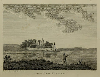
An old illustration showing the figure of a man casting his fishing road into a large body of water.  In the centre of the water is a small island with a ruined castle sitting on it.
Loch Orr Castle – illustration from The Antiquities of Scotland


 An illustration showing a ruined castle sitting on a small hill with several trees in the foreground.
Loch Ore Castle - illustration from The Castellated and Domestic Architecture of Scotland


At some point in the Eighteenth Century the castle was abandoned, and it fell into ruin.  In 1938 there were calls for the remains to be demolished, as they were seen by some to be dangerous due to subsidence in the area caused by mining.  The local council found that they did not have the powers to order the demolition, and luckily the owner of the land was unwilling to do so.  The castle ruins are now seen as being of special interest, given that it was probably one of the earliest castles built in Fife.


After my wander around the ruins, I left the Skulferatu that had accompanied me in a gap in the crumbling cement of the walls.


A photo showing a small, ceramic skull (Skulferatu #123) being held up with the ruins of Lochore Castle in the background.  Photograph by Kevin Nosferatu for the Skulferatu Project.
Skulferatu #123


A close-up photo showing a small, ceramic skull (Skulferatu #123) sitting in a gap in a stone wall.  A photo showing a small, ceramic skull (Skulferatu #123) sitting in a gap in a stone wall.  Photograph by Kevin Nosferatu for the Skulferatu Project.
Skulferatu #123 in in a gap in the crumbling cement


Photograph by Kevin Nosferatu for the Skulferatu Project.
Skulferatu #123 in in a gap in the crumbling cement


Google Map showing the location of Skulferatu #123
Map showing the location of Skulferatu #123


The coordinates for the location of the Skulferatu are -


Latitude 56.148461
Longitude -3.329002

what3words: hammocks.unroll.winters


I used the following sources for information on Lochore Castle –

 
The Antiquities of Scotland, Vol 2
by Francis Grose
1797
 
The Castellated and Domestic Architecture of Scotland from the Twelfth to the Eighteenth Century, Volume Three
By David MacGibbon and Thomas Ross
1889
 
Dundee Courier - Saturday 29 September 1906
 
Dundee Evening Telegraph - Thursday 15 December 1938


Tuesday, 9 May 2023

Skulferatu #96 - Tickleness Point, Burntisland, Fife


Sometimes I go and have a wander around a place just because I’ve seen it named on a map and have liked the name.    And that was the main reason I decided to go for a walk around this bit of the Burntisland coastline, I mean how could I resist a name like ‘Tickleness Point’?  Why it bares that name I have no idea, but it brought back childhood memories of the Mr Men books and Mr Tickle.  Hmmm, do you think in this day and age that particular Mr Man would be written into existence, what with his proclivity for the inappropriate touching, or tickling, of random people?  Probably not.


Only a short walk from the railway station, Tickleness Point is part of the Lammerlaws, on a peninsular that sticks out from the coast at Burntisland. 


I made my way along a path that curved up and around the hill at Tickleness Point.  Nearing the top, the earth was exposed and crumbling under the charred branches of burnt gorse.  Blackened branches that looked like they had been clawing their way out of the ground in a futile attempt to escape the flames. 


A photo of a hill with some rocks in the foreground - a view of Tickleness Point from the rocky seashore.  Photograph by Kevin Nosferatu for the Skulferatu Project.
View up Tickleness Point


A photo showing brown, crumbling soil on a slope with the blackened and burnt branches of some gorse bushes sticking out.  Photograph by Kevin Nosferatu for the Skulferatu Project.
Burnt gorse


A photo of brown, crumbling soil on a slope, in the centre is a rabbit burrow and all around are burnt gorse branches protruding from the earth.  Photograph by Kevin Nosferatu for the Skulferatu Project.
Burnt gorse and rabbit burrow


At the top of the hill were some ditches and mounds which are all that remains of a fort which once stood there.  The fort was believed to have been built by Oliver Cromwell’s men in the early 1650s, during the Third Civil War.  And, given the view over the Forth I could see why they would have built a fort there.


A photo showing a very grey scene over the Firth of Forth from Tickleness Point in Fife looking towards Edinburgh.  The hills of Edinburgh can be seen in silhouette.  Photograph by Kevin Nosferatu for the Skulferatu Project.
View over the Forth to Edinburgh from Tickleness Point


The military history of Tickleness Point did not end with Cromwell, as during World War II it was in use again, and a concrete pill box from that time still stands above some steep rocks overlooking the sea.


A photo showing a grey, concrete building perched above some steep rocks.  The windows of the building have been bricked up.  Photograph by Kevin Nosferatu for the Skulferatu Project.
Pill box on the rocks overlooking the sea


Near to where Cromwell’s fort stood are the remains of some lime kilns.  Lime kilns were used in the production of quicklime (Calcium Oxide), a product which had, and still has many uses.  It is used in the manufacture of cement and mortar, as a fertilizer, and was once used to mask the stench of rotting corpses.  Something that would have been quite important in the overcrowded graveyards of old.


A photo of an old, stone ruin beside the sea.  There is a curved passageway leading through it.  This is the ruin of the lime kilns at Tickleness Point.  Photograph by Kevin Nosferatu for the Skulferatu Project.
Lime kilns at Tickleness Point


A photo showing the lime kilns in the distance.  the sky is grey and ominous and there is a faded rainbow on the right-hand side.  Photograph by Kevin Nosferatu for the Skulferatu Project.
Lime kilns and rainbow


A close up shot of the ruins of the lime kilns showing that it is a crumbling stone structure with grass all around and bushes growing up to the left of it.  Photograph by Kevin Nosferatu for the Skulferatu Project.
Lime kilns at Tickleness Point


Nothing much is known of the history of the lime kilns, but they do make a nice landmark.


I left the Skulferatu that had accompanied me on my walk around Tickleness Point in a gap in the crumbling cement of the lime kilns.


A photo of a hand holding up a small, ceramic skull (Skulferatu 96).  In the background are the lime kilns.  Photograph by Kevin Nosferatu for the Skulferatu Project.
Skulferatu #96


A photo of a crumbling stone wall.  In the centre, in the crumbling cement, is a small, ceramic skull (Skulferatu 96).  Photograph by Kevin Nosferatu for the Skulferatu Project.
Skulferatu #96 in a gap in the crumbling cement


A close-up photo of the crumbling stone wall with a small, ceramic skull (Skulferatu 96) sitting in a hollow in the cement. Photograph by Kevin Nosferatu for the Skulferatu Project.
Skulferatu #96 in a gap in the crumbling cement


Google Map showing location of Skulferatu #96
Map showing location of Skulferatu #96


The coordinates for the location of the Skulferatu are –


Latitude 56.057339

Longitude -3.223469


what3words: spray.distracts.fats


I used the following sources for information on Tickleness Point –


Canmore – Tickleness Point
Canmore - Tickleness Point, Burntisland


The History of Burntisland

by Andrew Young

1913


For anyone unfamiliar with Mr Tickle, a narrated cartoon of the book is available on –

https://youtu.be/gPC3MmdTb-E