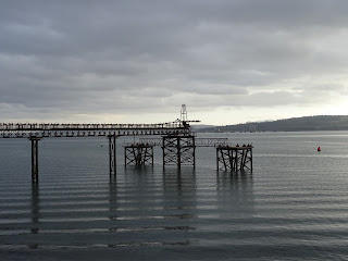
When out for walks along the Fife Costal Path I often stumble across the ruins of the heavy industry that once thrived in this area. There are pieces of machinery of indeterminate use, the remains of old buildings and piers, structures sitting out and decaying away in the water, and broken metal things that may have once been something useful but are now so rusted away it is difficult to say what they were.
Just outside of Inverkeithing there are
the rather striking remains of what looks like a disused, iron pier jutting out
into the Forth.
These are the remnants of a conveyer
belt and loading bay for Preston Hill Quarry.
It was once used to load stone from the quarry on to ships. The quarry was closed down many years ago and
the pier and loading bay have been left to just rust away.
I found a path through
the thorny bushes that took me underneath the rusting metal structure and while
I took some photographs a heron watched me warily from the water below.
I then took a wander over to the old
quarry site. It is now full of water and
is a popular place with the local diving community for training and underwater
photography. I tried my hand at a bit of
underwater photography by sticking an old and supposedly waterproof camera into
the water to take a photo of the reeds growing below the surface. It sort of
worked and the camera only fizzed and hissed a little bit.
There are now plans afoot to fill in the
quarry site and turn the area around it into a housing development. I got the impression from some stickers on signposts
and lampposts along the path leading up to the quarry that this is not a
particularly popular idea.
I wandered back round from the quarry to
the old pier and loading bay. The sun was
bright in the sky and all around was a haze of light reflected on a calm sea.
I left the Skulferatu that had
accompanied me on my walk in the iron struts of the pier supports.
The coordinates for the location of the
Skulferatu are –
Latitude 56.02553
Longitude -3.38618


No comments:
Post a Comment