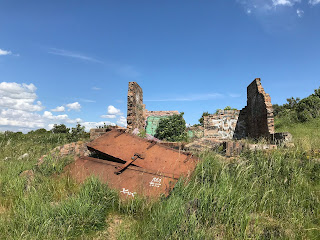
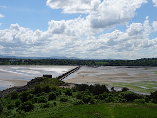
I only discovered the joys of the walk out to and around Cramond Island during lockdown. It was one of these places that I had always meant to go to though never quite got round to doing it. I had cycled and walked along the front at Cramond and passed the causeway out to the island many times but had just never ventured out there. One of the few joys of lockdown though was discovering new places to walk and making a point of actually going to places in my locale. So, for maybe the third time in a year I went on a stroll out there today. Before setting out I checked the tide times, crucial to avoid getting trapped on the island and wasting the time of the local Lifeboat crew. I then took a stroll along the causeway to the island.
The
causeway out to Cramond Island is a rough concrete path, raised a few feet up
from the sand. It is covered in cockles,
and I found myself dancing around the path trying not to squash them. Running along the side of the causeway is a
very distinctive looking barrier of concrete pylons, this was built in WWII as
an anti-boat barrier.
On
the island there is a path that takes you all the way around, past a host of
abandoned concrete and brick buildings.
These are the remains of the fortifications that were built here during
WWII and are the buildings that housed various gun emplacements and
anti-shipping searchlights. On one of
the beaches are two huge concrete blocks, these were anchor points for an
anti-submarine net that stretched over to Inchcolm Island and then over to the
Fife coast.
The
WWII buildings left on Cramond Island pale in comparison to those that can be seen
on the island of Inchmickery which sits between Cramond Island and the Fife
Coast. The island there is so covered in
the concrete remains of WWI and WWII fortifications that it looks like a large
battleship sitting out in the Forth. At
one point in time Inchmickery was famed for its oyster beds and the ‘rich profusion
of sea-weed, mosses and lichens, on its beach and surface.’ Now these have pretty much all disappeared.
Cramond
Island has a history stretching back into the mists of time. It is believed that the Romans would have
used the island during their time in Cramond, however no archaeological
evidence of this has been found.
In
1596 the island was the site of a duel which ended a long running feud. The feud came about after Mary Queen of Scots
had fled to England leaving behind various factions in Scotland who were
hostile to each other. Some supported
the Queen, while others supported James Stewart, the Earl of Moray, who was
acting as the Regent. One of those who
supported the Queen was Stephen Bruntfield, the Laird of Craighouse, while one
of those who supported the Regent was Robert Moubray, Laird of Barnbougle and
an arch enemy of Bruntfield. In 1572, Moubray,
who was hoping to ingratiate himself with the Regent, lay siege to Bruntfield’s
castle at Craighouse. Bruntfield held out
for a while but surrendered to Moubray when he was promised by the Regent that
his life would be spared, and he would keep his property and estates. Moubray however saw Bruntfield’s surrender as
a perfect opportunity to get rid of someone he despised, and while escorting
him to Edinburgh, to meet with the Regent, he ran him through with his sword
and murdered him. Bruntfield’s widow was
so overcome with grief at the death of her husband that she retired to her
rooms within Craighouse Castle, draped them in black and never left them
again. According to those who knew her,
she then spoke of nothing but having revenge on Moubray for the murder of her
husband. This obsession with revenge
she passed on to each of her three sons who each took a turn in duelling with
Moubray. The eldest, Stephen, was the
first to try his hand and Moubray slew him at a duel just outside Holyrood
Palace. A couple of years later, her
middle son, Roger, fought a duel with Moubray and seemed to be gaining the
upper hand, but he slipped and fell and Moubray struck off his head as he lay
on the ground. A few years after this,
the youngest son, Henry, also challenged Moubray to a duel. There was some debate about whether a duel
could be fought given that Moubray had already fought twice over the same issue,
but as Moubray was keen to fight again it was agreed that the duel could go
ahead. On Cramond Island, a spot was
chosen close to the northern beach with a raised area behind it where
spectators could gather. The duel then
took place, and it was bloody and long with both duellists seriously wounding
each other. Eventually as both were
stumbling with fatigue Henry found a last reserve of strength, lunged with his
dagger drawn at Moubray and stabbed him through the heart. Moubray gave a sigh of surprise at having
lost and fell down dead. Henry’s mother,
on hearing the news that Moubray had been killed and she had been revenged,
promptly dropped down dead as well.
Henry then later married Moubray’s niece and inherited much of Moubray’s
wealth and property.
Cramond
Island has also been the scene of many tragedies involving ships coming to
grief on the rocks around it, or people being drowned when caught by the tide
while making the crossing to and from the island. In 1954 a Gunner who was stationed on the
island, drowned while making his way back after a day’s leave. The incoming tide caught him as he tried to
wade out to the island and his body was found the next day lying in a rock
pool.
For
many years, the island was used for farming and grazing sheep. Though now uninhabited, up until the 1930s people
lived on the island, and an article in the West Lothian Courier of 1923
describes it as being the only inhabited island in the Forth. It goes on to describe there being ‘several
small red-tiled cottages upon the island.
In the most sheltered corner they lie, and were built, it is said, out
of the remains of a large house which used to stand there.’
It
was rumoured that there was an underground passage on the island that led, get
this for a nice and vague description, ‘somewhere’. This secret passage was described as having
been lost for centuries and it is probably no surprise to hear that no trace of
this has ever been found.
The
island was also one of the favourite haunts of the author Robert Louis
Stevenson and in his youth he and one of his friends would regularly canoe from
Granton out to Cramond Island.
Cramond
Island has also been the site of the DIY ‘Island of Punk’ festival. The festival lasts for a day with the
audience helping the bands to carry their equipment across the causeway to the
island. Various punk bands have played
there including local Edinburgh favourites such as Oi Polloi and Bloco Vomit.
On
my trek today around the island I left the Skulferatu that accompanied me in
the ruined wall of the Duck House, a building that was once a shelter for
shooting parties and later rented out as holiday accommodation. Now it is little more than a wall facing out
to the Forth Bridges.
The
coordinates for the location of the Skulferatu are –
Latitude 55.994815
Longitude
-3.291634
I used the following sources for information on Cramond Island -
Cassels Old and New Edinburgh, Vol 3
By James Grant
1883
The Book of Scottish Story
Various Authors
1896
The Scotsman 4th
June 1925
Favourite Haunts
of R.L.S.
West Lothian
Courier – Friday, August 3, 1923
Cramond Island –
An Appreciation
Belfast Telegraph – Monday,
August 16, 1954
Wikipedia
Article
and photographs are copyright of © Kevin Nosferatu, unless otherwise specified.


