Showing posts with label Kevin Nosferatu. Show all posts

Tuesday 24 October 2023

Skulferatu #107 - Lady Fyfe’s Brae and Giant’s Brae, Leith Links, Leith, Edinburgh


I have wandered around Leith Links many times.  I’ve gone to many fairs and events there, and up until recently had paid very little attention to the two mounds that jut out of the flat land of the park.  I’ve sort of noticed them in winter when kids would sledge down them, and also in summer when they are a hot spot for sunbathers, but other than that they have not really entered my consciousness much.  Probably because I’d always assumed, given Leith Links connection to the awful game that is golf, that they had something to do with that.  Then a few days ago I noticed that by each of them was a Brutalist lump of concrete with a chipped metal plaque on it.  These gave both the mounds a name, one as Lady Fyfe’s Brae and the other as Giant’s Brae, and stated that the former was the remains of Pelham’s Battery and the latter of Somerset’s Battery.  A quick bit of research later and it turned out that these two mounds were actually part of an important bit of local history back in 1560, the Siege of Leith. 


A picture of a grove of trees with a small, grassy hillock behind them - this being Lady Fyfe's Brae.  Photograph by Kevin Nosferatu for the Skulferatu Project.
Lady Fyfe’s Brae (Pelham’s Battery)


A photo of a park with a small hillock on it and a grove of trees behind it.  A small concrete block with a metal plaque on it can be seen in the foreground.  Photograph by Kevin Nosferatu for the Skulferatu Project.
Lady Fyfe’s Brae (Pelham’s Battery)


A photo of a park with a small hillock on it and a grove of trees behind it.   Photograph by Kevin Nosferatu for the Skulferatu Project.
Lady Fyfe’s Brae (Pelham’s Battery)


A view of a flat grassy park with some paths crossing it and various groves of trees on it - this is Leith Links as viewed from Lady Fyfe's Brae.  Photograph by Kevin Nosferatu for the Skulferatu Project.
View from Lady Fyfe’s Brae (Pelham’s Battery)


The events leading up to the Siege of Leith began almost a decade before.  In 1547, English troops arrived in Scotland, as part of the ‘Rough Wooing’ in an attempt to force the Treaty of Greenwich on the Scots, which would see Edward VI marry Mary, Queen of Scots in a union of the crowns.  Many of the English soldiers ended up camped near Edinburgh, at Leith Links.  Mary’s mother, Mary of Guise, worried by this development, asked the French Crown for assistance, and in 1548 French troops began to arrive in Leith.


In 1554, Mary of Guise became the Queen Regent of Scotland, her young daughter now being in France.  She then began to have fortifications built and improved around Leith.  While all this was going on the relationship between Mary, who was Catholic, and the Protestant Scots began to deteriorate.  By 1559, things had got so bad between them, that Mary felt she was in imminent danger and for a while she lived in Leith, where she felt she could be protected by the French troops, who were also Catholic and loyal to her.  Mary was later persuaded to move back to Edinburgh.  However, a group of Protestant noblemen who were unhappy with the French troops being in Leith, amassed an army, which led to Mary asking for more French troops to be sent over, and having the fortifications at Leith extended further with a large earthen rampart.  This in turn led to the Scots Protestants petitioning the English for their help in removing the French troops.


In April of 1560, English troops arrived at Leith and pounded the town with artillery fire.  This, however had little effect due to the rather formidable earthen wall that had been put up as a defence.  So, to give the guns a bit more elevation three mounds were built, two of these being the ones that still stand on Leith Links.  The guns then pounded Leith, and there were various attacks on the town by the English troops that were repelled by the French.   The siege then carried on with food becoming scarce for those in Leith with reports that the troops themselves were eating horse flesh and ‘the grass and weeds that grew on the ramparts.’  While the townsfolk trapped there were living off cockles picked from the shore and roasted cats and rats.


A photo showing grass in the foreground a grey path and then a grassy hillock behind.  At either side is a line of large, old trees.  Photograph by Kevin Nosferatu for the Skulferatu Project.
Giant’s Brae (Somerset’s Battery)


A photo of a daisy in the grass on the hillock, its centre is yellow, and its petals are white.  Photograph by Kevin Nosferatu for the Skulferatu Project.
Daisy in the grass Giant’s Brae (Somerset’s Battery)


A photo of a grassy hillock with large old trees on either side and a blue sky with white clouds above.  Photograph by Kevin Nosferatu for the Skulferatu Project.
Giant’s Brae (Somerset’s Battery)


The attacks against Leith continued with heavy losses on both sides.  After one attack, when the English army had again failed to break through and take the town, the French troops gathered up the bodies of those English soldiers who had been killed, stripped them naked and lined them up on the ramparts.  On seeing this, it was said that Mary ‘hopped with mirth’, and exclaimed, ‘Yonder is the fairest tapestrie that ever I saw. I wald that the haill feyldis that is betwix this place and yon war strewit with the same stuiffe.’  (Over there is the fairest tapestry I’ve ever seen.  I wish that all the fields between this place and over there were strewn with the same stuff.)


Mary’s joy was short lived though, as on the 11th of June 1560 she died, probably from heart failure.  After her death an armistice was agreed, and peace was then brokered, with the French and English troops leaving Scotland.  So yet again, like much of history, it appears that lots of people died for nothing much.


I left the Skulferatu that had accompanied me on my wander around Leith Links, in the bark of a rather nice tree that stands between the two mounds.


A photo of a flat grassy park with a line of trees.  The tree at the end of the line is of a lighter colour and looks quite vibrant.  There is a park bench underneath this tree.  Photograph by Kevin Nosferatu for the Skulferatu Project.
A rather nice tree that stands between the two mounds


A photo of a small ceramic skull (Skulferatu 107) being held up with the park of Leith Links in the background.  Photograph by Kevin Nosferatu for the Skulferatu Project.
Skulferatu #107


A photo of a small ceramic skull (Skulferatu 107) sitting in the bark of a tree on Leith Links.  Photograph by Kevin Nosferatu for the Skulferatu Project.
Skulferatu #107 in the bark of a tree on Leith Links


A photo showing a larger view of a small ceramic skull (Skulferatu 107) sitting in the bark of a tree on Leith Links. Photograph by Kevin Nosferatu for the Skulferatu Project.
Skulferatu #107 in the bark of a tree on Leith Links


Google Map showing location of Skulferatu #107


The coordinates for the location of the Skulferatu are –


Latitude 55.970178

Longitude -3.164135


what3words: dome.poem.lanes


I used the following sources for information on Lady Fyfe’s Brae, Giant’s Brae and the Siege of Leith –


Historical Notes Concerning Leith and its Antiquities, Vol 1 
by James Campbell Irons
1897

The Story of Leith
By John Russell
1922
 
Canmore

Tuesday 10 October 2023

Skulferatu #106 - Innerwick Castle, Dunbar, East Lothian


The ruins of Innerwick Castle sit on a sandstone outcrop, above a steep, rocky ravine that drops down through Thornton Glen, to the shallow waters of Thornton burn.  On the other side of the glen once stood Thornton Castle, of which nothing now remains. Whether there was some strategic importance to the castles being so close together I don’t know, though they were near to the Great North Road that ran from London to Edinburgh, so maybe they were some sort of strongholds against the English army, that occasionally marched up that way to carry out an invasion or get up to some mischief making. 


Built in the 14th Century, Innerwick Castle was once the stronghold of the Hamilton family, and the history of the castle, like that of many castles, is bloody and violent.  It fell into the hands of the English after their success at the battle of Homildon Hill in 1402.  Then, in 1406, it was besieged by the army of the Scottish nobleman, Robert Stewart, and was recaptured and destroyed.  A few years later it was rebuilt and appears to have enjoyed a period of prosperity when it was extended several times.


A photo of a jagged ruin of a red stone wall with trees on one side of it.  This is the first view of the remains of Innerwick Castle from the path leading up to it.  Photo by Kevin Nosferatu for the Skulferatu Project.
View of the ruins of Innerwick Castle


A photo of a ruin sitting on top of a red stone cliff.  Photo by Kevin Nosferatu for the Skulferatu Project.
View of the ruins of Innerwick Castle


A photo of a ruin sitting on top of a red stone cliff.  These being the remains of Innerwick Castle.  Photo by Kevin Nosferatu for the Skulferatu Project.
View of the ruins of Innerwick Castle


A photo of a ruin sitting on top of a red stone cliff.  The view is looking straight up underneath the rocks and the windows in the ruin and a gap in the rocks combine to make it look like a face.  Photo by Kevin Nosferatu for the Skulferatu Project.
View of the ruins of Innerwick Castle


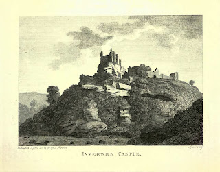
A sketch of a ruined castle sitting atop a cliff.
Sketch of Innerwick Castle from ‘The Castellated and Domestic Architecture of Scotland’


This period of peace and prosperity ended in the mid-16th Century when Scotland and England became involved in a series of vicious and violent confrontations, known as the ‘Rough Wooing’.  During this time the English forces carried out a series of attacks and invasions into Scotland, in an attempt to compel the Scottish Parliament to confirm the terms of the Treaty of Greenwich.  This treaty, which had been agreed by Henry VIII of England and James Hamilton, the Regent of Scotland, included a proposal that Mary, Queen of Scots, and Henry’s son Edward should wed when they were of age.  However, the Scottish Parliament had rejected the treaty, much to Henry’s displeasure.    In 1547, Henry was dead, and his young son was King, though the real power lay with his Protector, Edward Seymour, the Duke of Somerset.  And Seymour, being an ambitious sort, decided it was time to get the treaty sorted, so he led an army into Scotland.   


On the 6th of September 1547, a unit of English hakbutters (men armed with an early form of musket) besieged Innerwick Castle. The castle was defended by the Master of Hamilton and eight other men.  They barricaded the doors, blocked up the stairs and defended from the castle battlements. However, the hakbutters blasted away at them with their guns, and managed to force their way into the vaults below. There they piled up straw and wood and set the castle ablaze.  Blinded and suffocated by the smoke, those defending the castle cried out for mercy, but the hakbutters burst through the doors onto the battlements and shot dead eight of them on the spot.  The ninth, who saw what fate had befallen his comrades, jumped from the castle battlements in a desperate effort to save himself, falling 70 feet down the ravine and into the river below.  Miraculously, he survived and on seeing this, the hakbutters above in the castle, allowed him to escape.  Unfortunately for the poor man, he ran towards nearby Thornton Castle, unaware that it too was being attacked by English troops.  On being spotted by them he was ‘slain’.  Shortly after his death, Thornton Castle also fell into the hands of the English troops who blew it up with gunpowder.


A print of a ruined castle atop a cliff.
Innerwick Castle from ‘The Antiquities of Scotland’


A photo of an overgrown area with a ruined red stone wall sticking out with various empty window spaces in it.  Photo by Kevin Nosferatu for the Skulferatu Project.
View of the ruins of Innerwick Castle


A photo of an overgrown area with a ruined red stone wall sticking out of it.  Photo by Kevin Nosferatu for the Skulferatu Project.
View of the ruins of Innerwick Castle


A photo of an overgrown jumble of red stones that must have once been part of the walls of Innerwick Castle.  Photo by Kevin Nosferatu for the Skulferatu Project.
View of the ruins of Innerwick Castle


A photo of a stone arch that is almost hidden by the green of surrounding trees.  Photo by Kevin Nosferatu for the Skulferatu Project.
View of the ruins of Innerwick Castle


A photo of a stone corridor with an old arched doorway in it.  Photo by Kevin Nosferatu for the Skulferatu Project.
Vaults at Innerwick Castle


A view through a ruined stone doorway into an overgrown area with another doorway in the distance.  Photo by Kevin Nosferatu for the Skulferatu Project.
Vaults at Innerwick Castle


A photo of a tangle of tree branches that almost look like roots.  Photo by Kevin Nosferatu for the Skulferatu Project.
Tree over entrance into the vaults


A photo of a stone walled room with an arched roof and a window at the far end.  Photo by Kevin Nosferatu for the Skulferatu Project.
Vaults at Innerwick Castle


A photo of a small green plant growing in a hole in the wall of the castle.  Photo by Kevin Nosferatu for the Skulferatu Project.
Hole in the wall


A photo of a red stone wall made up of lots of different sized and shaped stones.  Photo by Kevin Nosferatu for the Skulferatu Project.
Stones in the wall


A photo of some faded graffiti on a red stone in the wall.  It shows a smiling sun and the name Gael M.  Photo by Kevin Nosferatu for the Skulferatu Project.
Graffiti on the vault walls


A photo of a large, ruined stone arched room.  There is now no wall at the back and the view out from it is of lots of trees.   Photo by Kevin Nosferatu for the Skulferatu Project.
Vaults at Innerwick Castle


Though much of Innerwick Castle was badly damaged by the attack in 1547, parts of it must have been habitable, as in the 1650s the Covenanters used it as one of their bases from which they harassed and attacked Oliver Cromwell’s troops.  Later, in the 1820s, the castle was home to a local man called Sandy Cowe.  Living there on his own, he grew garden plants in parts of the castle and on its grounds, which he sold around the county.


The ruins of Innerwick Castle have been an inspiration for many artists from the amateur to the well-known.  In 1831, J.M.W. Turner was invited up to Edinburgh to meet up with Sir Walter Scott and his publisher, to discuss his illustrating of Scott’s Poetical Works.  On his way up, after a stop off at Berwick upon Tweed, he spent a couple of days in East Lothian sketching some of the ruined castles there.  One of these castles being Innerwick.  The series of sketches he drew are now held by the Tate.


A sketch of Innerwick Castle sitting on the top of a cliff.
J. M. W. Turner - Innerwick Castle, East Lothian, 1831, Photo © Tate


The land in which the castle sits in is now a nature reserve owned by the Scottish Wildlife Trust.  A steep, narrow, earth trodden path leads up to it, and it was up this path that I trudged on a fine, still day.  Ignoring the sign warning of the dangers of loose masonry, I made my way inside the castle and wandered through what remained of the vaults and once grand rooms.  I took in the views over Thornton Glen and then after my wanderings, left the Skulferatu that had accompanied me, in a gap in the wall of a swirling tower where a stairwell to the upper levels had once stood.


A photo of a small ceramic skull being held up in front of the large, ruined stone arched room.  Photo by Kevin Nosferatu for the Skulferatu Project.
Skulferatu #106


A photo of a wall with an empty window low down and stones paced in the wall where steps would once have been.  In a gap in the wall, almost out of sight, sits a small ceramic skull (Skulferatu 106).  Photo by Kevin Nosferatu for the Skulferatu Project.
Skulferatu #106 in the swirling stairwell tower


A photo of a swirling wall with stones paced in the wall where steps would once have been.  In a gap in the wall, almost out of sight, sits a small ceramic skull (Skulferatu 106).  Photo by Kevin Nosferatu for the Skulferatu Project.
Skulferatu #106 in the swirling stairwell tower


A small ceramic skull (Skulferatu 106) sitting in a gap in a red stone in the wall of Innerwick Castle.  Photo by Kevin Nosferatu for the Skulferatu Project.
Skulferatu #106 in a gap in the wall


TomTom Map showing location of Skulferatu #106
Map showing location of Skulferatu #106


The coordinates for the location of the Skulferatu are –


Latitude 55.955625

Longitude -2.425939


what3words: aimlessly.stealthier.superhero


I used the following sources for information on Innerwick Castle –


Canmore
 
by Francis Grose
1797
 
The Castellated and Domestic Architecture of Scotland from the Twelfth to the Eighteenth Century
Volume Three
by David MacGibbon and Thomas Ross
1889
 
Tudor Tracts 1532 - 1588
Of the Expedition into Scotland by William Patten
1903
 

The Autobiography of a Working Man
1848 
by Alexander Somerville

 
Tate
 

Landscapes of Memory 
Turner as Illustrator to Scott
by Gerald Finley
1980


Tuesday 26 September 2023

Skulferatu #105 - Shell Grotto, Newhailes, Musselburgh


On a stroll through the Newhailes estate, I took shelter in the woods from the ominous dark clouds gathering in the sky.  There I came across a small and rather sorry looking building, this being the remains of the Shell Grotto.  It was once a rather grand, little structure that stood as a central feature in the water gardens.  These were a series of pools that were fed by a burn that runs through the estate.  The pools are now long gone and are just a series of dips in the ground.


A photo of the Shell Grotto at Newhailes, which is a small, roofless building with an arched doorway.  There is a swirling iron gate in the doorway and the facade of the building is constructed of rough, lumpy, and bumpy stone.  Photo by Kevin Nosferatu for the Skulferatu Project.
The Shell Grotto


In the Eighteenth Century, Shell Grottos were the must haves for fashionable, rich British landowners, and the owners of Newhailes, the Dalrymples, were rich enough and fashionable enough to have one built.  The Shell Grotto in Newhailes was one of the first built in Scotland and was probably built in the 1770s. 


A photo showing a closer view of the Shell Grotto at Newhailes, which is a small, roofless building with an arched doorway.  There is a swirling iron gate in the doorway and the facade of the building is constructed of rough, lumpy, and bumpy stone.  Photo by Kevin Nosferatu for the Skulferatu Project.
The Shell Grotto


A photo of the entrance of the Shell Grotto at Newhailes, showing the rough stones and patterned top stones around the doorway.  Photo by Kevin Nosferatu for the Skulferatu Project.
Entrance to the Shell Grotto


The Shell Grotto was constructed of large boulders and rubble, with the façade at the entrance being decorated with furnace slag and sponge-stone to give it a mysterious and eerie look, like the entrance to a volcanic cavern.  It was originally roofed in slate and had a floor of black marble.  The walls inside were at one time lined with wood covered in plaster, in which were embedded thousands upon thousands of seashells, precious stones and fragments of coloured glass all arranged into various patterns. 


The shells in the walls not only came from the local beaches, but also as far away as China.  In 1774, Jenny Dalrymple wrote to her brother William, who was in Canton, and asked him to find her shells from there for the grotto.


As well as being designed as a place for quiet contemplation, reading or just retreating from life for an hour or two, the Shell Grotto was also meant to be a place of mood and mystery.  Excavations there a few years ago, found that there had at one time been a chimney and a ‘stoke hole’ behind the grotto as well as flues in the walls of the building.  Rather than being constructed for heating the grotto, they appeared to have been designed to produce and emit smoke, to add a mysterious atmosphere to the building.


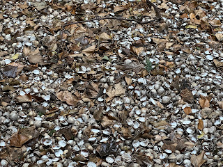
Though abandoned for many years, the interior of the Shell Grotto was intact up until the 1950s, when it was vandalised and set on fire.  Now the roof and the interior decoration are all gone.  Today, there are thousands of shells lying on the floor of the Grotto, but I don’t think any of them are the original shells from the walls, but rather are a recent addition in an attempt to put some shells back into the Shell Grotto.


A photo showing thousands of seashells lying on the ground of the floor of the Shell grotto at Newhailes.  Photo by Kevin Nosferatu for the Skulferatu Project.
Shells in the Shell Grotto


I left the Skulferatu that had accompanied me on my stroll to the Shell Grotto, in a dimple on a rock in the entrance façade.


A photo showing a hand holding up a small ceramic skull (Skulferatu 105) with the Shell Grotto building in the background.  Photo by Kevin Nosferatu for the Skulferatu Project.
Skulferatu #105


A small ceramic skull (Skulferatu 105) in a dimple in the rough rock at the top of the entrance to the Shell Grotto. Photo by Kevin Nosferatu for the Skulferatu Project.
Skulferatu #105 in a dimple on a rock in the entrance façade


A small ceramic skull (Skulferatu 105) in a dimple in the rough rock at the top of the entrance to the Shell Grotto. Photo by Kevin Nosferatu for the Skulferatu Project.
Skulferatu #105 in a dimple on a rock in the entrance façade


TomTom Map showing the location of Skulferatu #105
Map showing the location of Skulferatu #105


The coordinates for the location of the Skulferatu are –


Latitude 55.942634

Longitude -3.081671


what3words: crops.impose.park


For an idea of what parts of the decoration inside the Grotto may have looked like when it was complete, visit the website for the Shell Grotto in Margate.


I used the following sources for information on the Shell Grotto –


Tourist Information sign at site

Newhailes
By Hilary Horrocks
2004


Tuesday 5 September 2023

Skulferatu #104 – Ladies’ Walk, Newhailes, Musselburgh


I discovered the delights of the estate at Newhailes a decade or so ago when I was out cycling.  Going down a narrow path I came across a slight hill on one side with a path leading up to a gate.  So, of course, I had to go through and have a wander about to see what was there.  And what was there, was a pleasant walk through some woods up the Palladian style country house, which is Newhailes House.  Built by the architect, James Smith, in 1686, the house was once the home of the Bellenden family and was then inherited by the Dalrymple family, close relatives of the Bellends, sorry cheap joke, Bellendens.  In 1997 the house was given to the National Trust.


A photo of a large country mansion house, Newhailes House, framed under the branch of a tree in the foreground.  Photograph by Kevin Nosferatu for the Skulferatu Project.
Newhailes House


Today, on a leisurely walk through the estate, I cut along the pathway through the fields in front of the house, to the Ladies’ Walk.  The Ladies’ Walk is an elevated path that runs for about a quarter of a mile through the grounds of Newhailes.  It was designed to allow the rather delicate, aristocratic ladies who lived in, or were visiting Newhailes House, to partake in gentle exercise and conversation with each other.  The path bordered a sheep field on one side and a field of cattle on the other, so being elevated it meant the good ladies of the time wouldn’t be bothered by pesky livestock.  It also provided views over the surrounding grounds and countryside.  At one time there was a humped bridge that led to a viewing platform.  There, visitors had unimpeded views to the Forth and down to the hectic and the busy harbour in Musselburgh. 


A picture showing a raised walkway between two fields with a small bridge in the foreground.  Two genteel ladies are walking along the walkway.  There are cows in the right hand side field and sheep in the left.  In the background amongst some trees is a stately home (Newhailes House).  Photograph by Kevin Nosferatu for the Skulferatu Project.
Picture of how Ladies’ Walk would have looked in the 18th Century
from the tourist Information sign at site


Built around the 1740s, the walk originally had a hedge on its eastern side to act as a barrier against the wind. Now, most of the walk is covered in trees, bushes, thistles and lots of prickly plants, though there are bits that are covered in wild grasses which are accessible. 


While out on my walk I clambered up a low stone wall and walked through the thick, damp grass on part of the pathway.  Feeling quite genteel, I took in the views and breathed in the fine summer air, just like the ladies of old would have done a couple of centuries ago.


A view along a very overgrown path with lots of tall grasses growing along it.  Photograph by Kevin Nosferatu for the Skulferatu Project.
The present view along Ladies’ Path


A view along a very overgrown path with lots of tall grasses growing along it.  Photograph by Kevin Nosferatu for the Skulferatu Project.
The present view along Ladies’ Path


A view over some fields to a mansion house in the distance.  Trees grow on either side of the house.  Photograph by Kevin Nosferatu for the Skulferatu Project.
View of Newhailes House from Ladies’ Path


A photo showing an ivy grown lump sticking out through the long grasses of an overgrown path.  Photograph by Kevin Nosferatu for the Skulferatu Project.
View from Ladies’ Path


Making my walk to the red brick remains of where the bridge to the viewing platform had stood, I left the Skulferatu that had accompanied me in a gap where the cement had crumbled away.


A photo of a red brick platform with grass growing along the top of it.  Photograph by Kevin Nosferatu for the Skulferatu Project.
Remains of the platform for the bridge


A photo of a side view of the red brick platform with grass growing along the top of it.  Photograph by Kevin Nosferatu for the Skulferatu Project.
Remains of the platform for the bridge


A photo showing a hand holding up a small ceramic skull (Skulferatu 104) with the red brick platform in the background.  Photograph by Kevin Nosferatu for the Skulferatu Project.
Skulferatu #104


A photo of a small ceramic skull (Skulferatu 104) sitting in a gap between the red bricks of the platform.  Photograph by Kevin Nosferatu for the Skulferatu Project.
Skulferatu #104 in a gap between the bricks


A photo of a small ceramic skull (Skulferatu 104) sitting in a gap between the red bricks of the platform.  Photograph by Kevin Nosferatu for the Skulferatu Project.
Skulferatu #104 in a gap between the bricks


TomTom Map showing location of Skulferatu #104
Map showing location of Skulferatu #104


The coordinates for the location of the Skulferatu are –


Latitude 55.944467

Longitude -3.077433


what3words: starts.fines.civic


I used the following sources for information on Newhailes and Ladies’ Walk –


Tourist Information sign at site


Newhailes 

by Hilary Horrocks

2004


Canmore

Canmore - Ladies Walk, Newhailes