Showing posts with label Kevin Nosferatu. Show all posts

Tuesday 7 May 2024

Skulferatu #119 - Former Site of Shanks Waste Solutions, West Shore Road, Granton, Edinburgh


Oh, I do like to find a nice bit of wasteland to wander around.  A place of concrete remnants, now overgrown with bushy and scraggy plants.  A place that was once busy with people and is now the domain of rodents, rabbits, songbirds and the ever present screeching seagulls.


On a walk from Leith to Cramond, I came across a scrubby piece of land where there use to be a liquid waste processing plant run by Shanks Waste Solutions.  What sort of liquid was processed here I have no idea, but I’m sure it was pretty nasty, chemical stuff or some sort of revolting medical gunk. 


View of a metal fence with various signs on it.  In front of it are two concrete blocks and a large blue waste bag that is full.  Photo by Kevin Nosferatu for the Skulferatu Project.
Entrance to the site


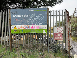
View of a metal fence with two signs on it.  One reads Shanks Waste Solutions, Granton Plant, and the other is a No Smoking sign that is broken in half. Photo by Kevin Nosferatu for the Skulferatu Project.
Granton Plant


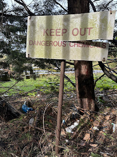
A photo of a rectangular sign on a rusty metal pole.  The sign has a split along one side.  The sign reads - Keep Out Dangerous Chemicals.  Photo by Kevin Nosferatu for the Skulferatu Project.
KEEP OUT Dangerous Chemicals


a photo of a yellow metal structure of metal bars with a pipe at the bottom and a stop valve on it.  Photo by Kevin Nosferatu for the Skulferatu Project.
A metal thing


A view of a row of stone blocks lying on the ground.  One is a semi-circle shape and someone has spray painted the word 'Hi' on it.  Photo by Kevin Nosferatu for the Skulferatu Project.
‘Hi’ – dumped stone blocks


In 2005, the site was sold for £6 million to Waterfront Edinburgh Ltd.  They were going to redevelop this land as part of the multi-million pound regeneration project taking place in Granton.  However, they are now in voluntary liquidation, so who knows when the site will be redeveloped, or what it will end up as. Whatever happens, it will no doubt remain as a bit of wasteland for the next couple of decades.


While wandering around, I came across three large metal containers that probably once contained something nasty and noxious.  I think they are now empty, but didn’t investigate that too closely.


A photo showing a large metal container sitting on a flat area of land that is now overgrown with scrubby plants.  On the left hand side is a row of trees.  Photo by Kevin Nosferatu for the Skulferatu Project.
Large metal container


A photo showing part of one of the large metal containers on the right hand side with another sitting in the distance.  Photo by Kevin Nosferatu for the Skulferatu Project.
Large metal containers


A photo showing a large metal container sitting on a flat area of land that is now overgrown with scrubby plants.  On the right hand side sits lies a discarded block of a portable fencing barrier.   Photo by Kevin Nosferatu for the Skulferatu Project.
Large metal container


360 view of the large metal containers


Walking down to the far fence of the site, I took in the view up to the Granton Gas Holder, a piece of Edinburgh’s industrial heritage that is now being restored as part of the project to regenerate the Granton Waterfront. The clank of hammers on metal echoed down from there, mixing in with the gentle lapping of waves on the nearby shore.


A view showing large rocks in the foreground with a background of scrubby land that leads up to a Victorian style gas holder frame in the distance, a round metal structure of curved beams.  Photo by Kevin Nosferatu for the Skulferatu Project.
View up to Granton Gas Holder


Standing there in the dull half-light of a dank and damp winter’s day, I watched as rabbits skittered by in twitchy nervousness.  A nervousness that only those on the lowest rung in the food chain can feel. A crow then circled around me and dropped a mussel onto the hard concrete ground surface.  Swooping down, the crow then tore out the flesh from the shattered shell, cawed loudly in satisfaction at its tasty snack, and then flew off again.  The ground was covered with the shattered shells of many such meals.


A photo of a view along a flat piece of land to a metal fence.  Behind the fence can be seen the sea and the shores of Fife.  Photo by Kevin Nosferatu for the Skulferatu Project.
Concrete ground


A view of a grey metal fence with a grey sea behind it and a grey sky above.  Photo by Kevin Nosferatu for the Skulferatu Project.
Fence and the Forth


Feeling some spots of rain hitting the exposed skin of my bald head, I made my way back out of the site.  As I left, I placed a Skulferatu on a large rusty screw holding one of the metal containers together.  There it could guard over whatever nasties were held within.


A photo of a small, ceramic skull (Skulferatu 119) being held up with a large metal container in the background.  Photo by Kevin Nosferatu for the Skulferatu Project.
Skulferatu #119


A picture of the corrugated surface of one of the metal containers.  On one of a set of four rusty screws on the container sits the small, ceramic skull (Skulferatu 119).  Photo by Kevin Nosferatu for the Skulferatu Project.
Skulferatu #119 on a large rusty screw


A picture of four rusty screws on the metal container with the small, ceramic skull (Skulferatu 119) sitting on one of the screws.  Photo by Kevin Nosferatu for the Skulferatu Project.
Skulferatu #119 on a large rusty screw


TomTom Map showing location of Skulferatu #119
Map showing location of Skulferatu #119


The coordinates for the location of the Skulferatu are –


Latitude 55.982926

Longitude -3.250747


what3words: cone.causes.armed


Tuesday 30 April 2024

Skulferatu #118 - Hopetoun Monument, Byres Hill, Haddington, East Lothian


On a lonely hill in East Lothian there stands a rather phallic looking stone tower.  It dominates the skyline for miles around, shouting out to all – ‘Look at me!  Look at me!’  It is meant to remind all who see it of the valour and heroism of a long forgotten member of the aristocracy.  A career soldier who fought in the battles against Napoleon and his ambitions of empire, but who also fought to seize and steal land for the British Empire.   A man, who in his time was seen as being brave, daring, God fearing, and everything that a man of his class should be.  A man, who in our time, is seen as taking part in actions on behalf of the British Empire and his own wealth, that are morally repugnant.


A photo showing a tall, thin stone tower rising up from a sea of green gorse bushes and up into a blue sky.  Photo by Kevin Nosferatu for the Skulferatu Project.
The Hopetoun Monument


John Hope, our ‘hero’ memorialised by the Hopetoun Monument, was born in 1765 and was part of the aristocratic Hopetoun family.  He took the title of the Earl of Hopetoun when his half-brother died in 1816.  John joined the army at a young age and quickly rose to the rank of Brigadier-General.  In 1794, he was in the West Indies where he took part in various campaigns, including the brutal crushing of the slave rebellion in Grenada.  He then took part in various battles in Europe and Egypt and served under the Duke of Wellington at the Battle of Nivelle and the Battle of Nive.  In 1814 he was severely wounded at the Battle of Bayonne and was taken prisoner by the French.  On his release, he returned to Scotland to recuperate.  His military service over, he enjoyed the wealth from the various lands he had inherited around Scotland, and also the wealth generated from the plantations he now owned in Granada and Dominica.  He later went on to be the Governor of the Royal Bank of Scotland, The Lord Lieutenant of Linlithgowshire and the Captain-general of the Royal Company of Archers.  He died while in Paris in 1823, with his body then being repatriated back to Britain and buried in the family vault at Abercorn.


At the time of his death, John Hope was a popular man, not only amongst the great and the good of the land, but also amongst the general population.  The tenants and the farmers on his land appeared to have held him in high regard as a good man and a good landlord.  Various discussions into monuments to his life were had, and he ended up with several.  These are, the Hopetoun Monument at Byres Hill, another Hopetoun Monument in Fife, and then a statue of him on horseback that now sits outside Dundas House in the New Town of Edinburgh.


Work on the Hopetoun Monument began on the 8th of May 1824, when the foundation stone was laid. On a day of torrential rain, a huge procession took place up Byres Hill, a procession of ‘ladies and gentlemen’ from the surrounding countryside, various craftsmen, and marching bands.  Hordes of local people braved the terrible weather to come and watch the event.  Then, with much pomp, the first stone of the tower was laid down on the site. 


Once completed the tower stood ninety-five feet tall, with a hundred and thirty-two steps spiralling up to reach the viewing platform at the top.


***


On a cold and crisp day, I walked up the dirt path round Byres Hill that led to a steep slope up through some woods of almost naked trees, the forest floor carpeted in their leaves of orange and gold.  I then emerged out of the woods to a ring of gorse bushes that appeared to encircle the tower as if they were protecting it, much like the thorn bushes that grew around Sleeping Beauty’s castle.  Luckily for me though, there was no having to cut my way through, as the path led me out and up to the grassy area where the tower stands.


A view through some bare branched trees over to some green fields and hills.  Photo by Kevin Nosferatu for the Skulferatu Project.
View from the woods at Byres Hill


A view through a haze of tree branches to a tall stone tower (The Hopetoun Monument).  Photo by Kevin Nosferatu for the Skulferatu Project.
The Hopetoun Monument – through the trees


A view of a tall stone tower framed by two naked, skeletal trees.  Photo by Kevin Nosferatu for the Skulferatu Project.
The Hopetoun Monument – through the naked trees


A view of a tall stone tower (The Hopetoun Monument) standing on a grassy area of a hill.  Two people are sitting down on the ground against it.  Photo by Kevin Nosferatu for the Skulferatu Project.
The Hopetoun Monument


Walking up to the tower I could see that the iron gate was open and inviting me to come inside.  So, in I went.  A steep and narrow spiral staircase led up and up.  It made me think of another childhood fairy tale and so I cried out ‘Rapunzel, oh Rapunzel, let down your hair.’ Alas, there was no answer, only the eerie howl of the wind through the window slats in the stone. 


A view of the doorway into the tower.  There is an opened metal gate and the lattices of it are shadowed on the tower wall.  Photo by Kevin Nosferatu for the Skulferatu Project.
The opening to the tower


A view of sunlight streaming through an opening in a wall.  A spiral staircase can be seen twisting down by the wall.  Photo by Kevin Nosferatu for the Skulferatu Project.
The spiral staircase


As I made my way further up I found that on the ledges on these slats there were the abandoned nests of some ravens, who had made the tower their home for a brief time.  From the nests of twigs and sticks and downy feathers, they must have had a good view of the land below.  By the nests the stairs became thick with fallen sticks that crunched under my feet like the dried bones of some long dead tiny creatures.  Climbing further up, the tower grew darker and darker.  My hands against the walls I trod carefully, the crunch, crunch of my feet becoming louder as the light grew fainter and fainter.  The dark and the screaming howl of the wind made me feel slightly nervous about what was ahead, and I thought about turning around and going back down.  But, just as my fear was getting the better of me, there was light.  Another window slat and then as I walked up I could see the entrance out onto the tower viewing platform.  Pulling myself up on a slightly wobbly iron handrail, I was out into the bright light of a view that stretched for miles and miles.  I could see over the whole of East Lothian, down to the Borders, across to sea to Fife and over to Edinburgh and beyond.


A view over the land from the Hopetoun Monument showing fields stretching off into the distance.  The silhouette of the monument and the hill on which it sits can be seen on the land below.  Photo by Kevin Nosferatu for the Skulferatu Project.
Silhouette of Byres Hill and the tower


A view from the monument over green fields to a small but steep hill, Berwick Law and in the distance the dark rock of the Bass Rock.  Photo by Kevin Nosferatu for the Skulferatu Project.
View over to North Berwick, Berwick Law, and the Bass Rock


A view over fields and a curving coastline to a hill - Arthur's Seat in Edinburgh.  Photo by Kevin Nosferatu for the Skulferatu Project.
View over to Edinburgh


I took in the view, despite the howling wind that wanted to pluck me from the tower and throw me far, far away.  Then, finding a small hole in the tower wall, I placed a Skulferatu there before making my way back down the narrow, winding stairs and out onto the hill.


A photo of a small ceramic skull (Skulferatu 118) being held up with the view from Hopetoun Monument in the background.  Photo by Kevin Nosferatu for the Skulferatu Project.
Skulferatu #118


A photo of a small ceramic skull (Skulferatu 118) nestling in the crack in a stone wall.  Photo by Kevin Nosferatu for the Skulferatu Project.
Skulferatu #118 in a hole in the tower wall


A photo of a small ceramic skull (Skulferatu 118) nestling in the crack in a stone wall.  Photo by Kevin Nosferatu for the Skulferatu Project.
Skulferatu #118 in a hole in the tower wall


Google Map showing the location of Skulferatu #118
Map showing the location of Skulferatu #118


The coordinates for the location of the Skulferatu are –


Latitude 55.978075

Longitude -2.801577


what3words: squad.dusts.thrusters


I used the following sources for information on Hopetoun Monument and John Hope –


‘The Late Earl of Hopetoun’ - The Scots Magazine - Wednesday 1 October 1823
 
‘Earl of Hopetoun’s Funeral’ - Morning Advertiser - Thursday 9 October 1823
 
‘Scottish Intelligence’ - The Scotsman - Saturday 8 May 1824
 
The Scotsman – 28 June 2020
 
Canmore
 
Wikipedia


Tuesday 26 March 2024

Skulferatu #116 - Bilston Glen Viaduct, Loanhead, Midlothian


I do love wandering around bits of our industrial past, whether that be an old railway, a derelict factory, old mineworks or a repurposed power station.  On a stroll from Roslin to the outskirts of Edinburgh, I walked over a piece of our industrial heritage – Bilston Glen Viaduct, or as locals refer to it, the Bilston Climbing Frame.  Wandering down a steep and narrow path under the viaduct I could see why it had acquired that name with the criss-crossing of the iron lattice work underneath.


A photo showing three black metal bollards across a pathway that leads along the walkway of a bridge.  The latticed metal railings of the bridge rise at both sides of the path.  Photo by Kevin Nosferatu for the Skulferatu Project.
Bollards by the viaduct


A photo on the pathway across the bridge (Bilston Glen Viaduct) with the iron latticed railings at each side. Photo by Kevin Nosferatu for the Skulferatu Project.
Path across the viaduct


A view of trees in a woodland scene.  Green ferns grow in between them.  Photo by Kevin Nosferatu for the Skulferatu Project.
Wooded area of Bilston Glen


A view of the iron girders beneath Bilson Glen Viaduct. Photo by Kevin Nosferatu for the Skulferatu Project.
Underneath the viaduct


A view across the underneath of the viaduct showing a mass of criss-crossed iron that makes up the supports and frame of the bridge. Photo by Kevin Nosferatu for the Skulferatu Project.
The criss-crossing iron lattice work underneath the viaduct


A view showing one side of the iron viaduct crossing over to the other bank.  Trees grow on the left-hand side. Photo by Kevin Nosferatu for the Skulferatu Project.
View of the viaduct


Another view showing one side of the iron viaduct crossing over to the other bank.  Trees grow on the right-hand side. Photo by Kevin Nosferatu for the Skulferatu Project.
View of the viaduct from Bilston Glen


Bilston Glen Viaduct is an old iron railway bridge above the steep gorge of Bilston Glen. The Edinburgh, Loanhead and Roslin Railway used to run across it.  This railway carried coal and ironstone from mines at Penicuik, Roslin, Bilston, Loanhead and Gilmerton.  It also carried passengers to Roslin.


The viaduct was built in 1892, and replaced an earlier one built at the same spot in the 1870s.  It appears that there had been concerns about the earlier bridge due to movements of the ground caused by the mineworks.  Concerns were also raised about the design of that bridge, as it had been designed by Sir Thomas Bouch, the designer of the infamous Tay Bridge that had collapsed in 1879.


Bilston Glen Viaduct was built with a single deep wrought iron span supported on low piers with granite abutments at each end to support it.  The separate pieces of the bridge were all made in Glasgow and then brought out to the site where the bridge was then assembled.  As the viaduct is made of iron it expands and contracts in the heat.  On a hot summer’s day, it could be up to 2 ½ inches longer than it was on a cold winter’s day.  To avoid this damaging the supports, the bridge was fitted with expansion mountings.  These allow the bridge to move. 


 In 1969 the section of the railway that ran over the viaduct was closed.  In 1999 restoration work was carried out on the viaduct and it opened again as part of the walkway that follows the old railway line.


While wandering around under the viaduct, I left a Skulferatu in a gap in the granite stonework of the abutments supporting it.


A hand holding up a small ceramic skull (Skulferatu #116) with the underneath of the viaduct in the background. Photo by Kevin Nosferatu for the Skulferatu Project.
Skulferatu #116


A small ceramic skull (Skulferatu #116) sitting in a gap in a stone slab covered in lichen. Photo by Kevin Nosferatu for the Skulferatu Project.
Skulferatu #116 in a gap in the granite stonework


A close-up view of the small ceramic skull (Skulferatu #116) sitting in a gap in a stone slab covered in lichen. A small ceramic skull (Skulferatu #116) sitting in a gap in a stone slab covered in lichen.​ Photo by Kevin Nosferatu for the Skulferatu Project.
Skulferatu #116 in a gap in the granite stonework


TomTom Map showing location of Skulferatu #116
Map showing location of Skulferatu #116


The coordinates for the location of the Skulferatu are –


Latitude 55.87089

Longitude -3.150976


what3words: herb.windmill.widen


I used the following sources for information on Bilston Glen Viaduct –


Tourist Information Board at site
 
Canmore
 
Edinburgh and Lothians: Exploring the Lost Railways
Alasdair Wham
2006


Tuesday 5 March 2024

Skulferatu #115 - Gabriel's Pier, Gabriel's Wharf, Southbank, London


On yet another of the hottest days of the year, I was on a short stay over in London before heading back home.  So, what to do in that heat?  Well, I did the most sensible thing I could do, and as usual, went out in it.  As I was staying near to the Thames, and the tide was low, I thought I’d make my way there and wander along by the shores of the river to do a bit of mudlarking.


I wandered along the white hot pavements by Waterloo, and then cut through the back streets until I arrived at Gabriel’s Wharf.  There I made my way past the trendy, overpriced coffee shops and eateries, to a set of stairs that led me down onto a sandy beach by the Thames.


A photo taken from underneath a tree with branches hanging above, showing lots of people walking along a paved area that is fenced alongside a river.  Photo taken by Kevin Nosferatu for the Skulferatu Project.
Busy people at Gabriel’s Wharf


A view along the shoreline of the Thames showing a pebbled foreshore with large buildings running along the right side and a bridge in the distance crossing over the river to a host of other new and old buildings.  Photo taken by Kevin Nosferatu for the Skulferatu Project.
Gabriel’s Pier and the shoreline along the Thames


A view of a wooden pier jutting out over the foreshore.  A couple of people are sitting on a pebble beach and a child is running by.  Photo taken by Kevin Nosferatu for the Skulferatu Project.
Gabriel’s Pier and a bit of beach


This little bit of beach was busy with sunbathers and lots of children who were swimming in the brown, swirling waters of the river.  Though I was wilting in the heat I wasn’t going to join them in the cool water, as I remembered the stories of old about how dirty the Thames was.  There was one in particular about a passenger boat that sank sometime in the eighteenth century.  The story goes that of the hundred or so passengers on the boat, around twenty survivors were pulled from the river.  Within a week they had all died, poisoned by the water they had ingested while in the Thames.  The story, like many, may not be true, but the river was once horribly polluted and dirty, and even though it has now been cleaned up massively, you wouldn’t catch me swimming in it.


Leaving the beach area, I walked under Gabriel’s Pier and followed the shoreline along the Southbank, past the OXO building and towards Blackfriars Bridge.  Scraping at the stone and mud with my feet I found a few clay pipe stems and bowls, and a couple of small stones that had been cut into a circular shape with a whole drilled in the middle.  What they were I had no idea, but stuck them into my pocket anyway.


A view over the rocky and muddy shoreline of the Thames at low tide with lots of historic buildings on the banks on the left side of the photo and a bridge crossing over the river.  Photo taken by Kevin Nosferatu for the Skulferatu Project.
Shoreline along the Thames


Finding a relatively dry outcrop of rocks I sat down to watch life on the river.  Tourist boats sped past whipping the shoreline with rough waves, a couple of barges ambled by, and a group of a dozen or so canoeists paddled along, bouncing merrily in the waves of the passing boats.  Seagulls soared over, screeching, and gabbling in the way that seagulls do, and up above on the walkways around the shore was the distant mumble of the thousands of people out and about in the hot, hot sun.


After daydreaming for a while on my seat of rock, I walked back along the shore to Gabriel’s Pier, which like Gabriel’s Wharf, is named after Christopher Gabriel, whose family business was based here from the 1770s until 1919. 


A wooden structure of posts and planks standing over a beach of stones and pebbles.  Photo taken by Kevin Nosferatu for the Skulferatu Project.
Gabriel’s Pier


A view under the wooden structure of Gabriel's Pier looking down the beach towards the waters of the Thames.  There are wooden posts on both sides with the floor of the pier above.  In the middle there are several posts standing at angles against each other.  Photo taken by Kevin Nosferatu for the Skulferatu Project.
Under the pier


In a tangled wooden thing that had been fixed between the struts of the pier, I left the Skulferatu that had accompanied me on my walk.


A photo showing a small ceramic skull (Skulferatu 115) being held up with a wooden pier and the Thames shoreline in the background.  Photo taken by Kevin Nosferatu for the Skulferatu Project.
Skulferatu #115


A photo showing a small ceramic skull (Skulferatu 115) in a tangled branch like thing stuck to the side of the wooden struts of Gabriel's Pier.  Photo taken by Kevin Nosferatu for the Skulferatu Project.
Skulferatu #115 in a tangled wooden thing


A close-up view of the small ceramic skull (Skulferatu 115) in a tangled branch like thing stuck to the side of the wooden struts of Gabriel's Pier.  Photo taken by Kevin Nosferatu for the Skulferatu Project.
Skulferatu #115 in a tangled wooden thing


TomTom Map showing location of Skulferatu #115
Map showing location of Skulferatu #115


The coordinates for the location of the Skulferatu are –


Latitude 51.508557

Longitude -0.109673


what3words: until.swaps.wiped


Tuesday 27 February 2024

Skulferatu #114 - Botany Bay, Broadstairs, Kent


Some days all you really want is a good beach.  Today was one of those days.  With an egg sandwich and a bottle of water in my bag, I walked along to Botany Bay near Broadstairs.  Not to be confused with Botany Bay in Australia, the landing place of Captain Cook.


A photo showing a bay shaped beach (Botany Bay) with groups of people sunbathing on it.  Photo by Kevin Nosferatu for the Skulferatu Project.
View over Botany Bay


A photo showing an overgrown area with a white and yellow sign sticking out of it.  In the top white area are an exclamation mark in a blue circle and another exclamation mark in a yellow triangle.  In the bottom yellow part are the words - KEEP OUT – Unstable Cliff Edge.  Photo by Kevin Nosferatu for the Skulferatu Project.
KEEP OUT – Unstable Cliff Edge


Walking down on to the golden sands, I left my shoes behind and went for a paddle around the many rock pools.  As I usually do when I’m here, I had a scout around for fossils, as this is an area renowned for its fossils.  I didn’t find any, though did find a rather ergonomic light sort of stone that fitted in the grasp of my hand like it had been specifically designed for that purpose.  It went in my pocket.


Back on the beach the white cliffs towered above me, while just along from me were two chalk stacks where an endless array of scantily clad people posed for selfies. 


A picture showing bucket type sandcastles on a sandy beach with the sea in the background.  Photo by Kevin Nosferatu for the Skulferatu Project.
Sandcastles on the beach at Botany Bay


A photo showing a tall chalk stack on a beachy area with a white chalk cliff a few metres away from it.  A woman in pink in walking along the sand between the stack and the cliff.  Photo by Kevin Nosferatu for the Skulferatu Project.
Chalk stack at Botany Bay


I ate my egg sandwich, drank my water, and pondered on the fact that a couple of hundred years ago, rather than being a tourist spot for sunbathers and fossil hunters, Botany Bay, like many of the bays around this area of Kent, was notorious for smugglers.  One of the most famous of these was Joss Snelling, who led the Callis Court Gang.  On a cold winter morning in 1769, Joss and his gang were down on the beach at Botany Bay.  There, boatmen had delivered a load of illegally imported wine, brandy, schnapps, and tea.  The gang were just loading it onto carts when they were ambushed by a party of Excise Men.  A bloody battle between the two groups then took place, leaving most of the gang either captured or dead, one of the Excise Men dead, and several of them seriously injured.  Snelling and a couple of his men escaped and though suspected of being members of the gang, were not prosecuted.  Within a few months Snelling was back smuggling and had quickly replaced his lost gang members with new recruits.  


Snelling carried on his smuggling activities until he was an old man.  At the age of 89, he and a friend were prosecuted after Excise Men found them on Kingsgate beach by a load of kegs of brandy and rum.  In court Snelling and his friend both stated that they were not involved in smuggling, but rather had found the kegs on the beach while out walking and decided to take them. As there was no evidence of them being involved in smuggling, they were both instead fined for possessing illegally imported goods.   


Snelling went on to live to the grand old age of 96 and had achieved such notoriety that in 1829 he was introduced to the future Queen Victoria as ‘the famous Broadstairs smuggler.’


A photo of a chalk stack on the beach at Botany Bay.  A shallow sea cave area can be seen in it.  Photo by Kevin Nosferatu for the Skulferatu Project.
Chalk Stack at Botany Bay


Another view of the chalk stack on the beach at Botany Bay.  A shallow sea cave area can be seen in it. Photo by Kevin Nosferatu for the Skulferatu Project.
Chalk Stack at Botany Bay


A view of the white chalk cliff with a stubby angular chalk stack standing next to it.  Photo by Kevin Nosferatu for the Skulferatu Project.
Chalk Stack at Botany Bay


A photo showing the letters J F carved into the white chalk of the cliff.  Photo by Kevin Nosferatu for the Skulferatu Project.
Graffiti in the chalk cliffs


In the heat of the afternoon sun, I went for another quick paddle and a wander.  Looking around the chalk of the cliffs and the stacks I found lots of graffiti carved into them.   I didn’t remember there being so much last time I visited, and in my memory the cliffs were almost a pure, virginal white.  But hey, memory plays tricks, and it was quite a while since I last visited.


As the beach became busier, I decided it was time to make my way home.  Before departing, I left a Skulferatu in a skull and crossbones that someone had carved into the chalk.  


A photo showing a small ceramic skull (Skulferatu 114) being held up with the chalk stack on Botany Bay in the background.  Photo by Kevin Nosferatu for the Skulferatu Project.
Skulferatu #114


A photo showing a primitive looking skull and crossbones carved into the white chalk cliffs at Botany Bay.  The chalk around it is dirty and dark.  Photo by Kevin Nosferatu for the Skulferatu Project.
Skull and crossbones carved into the chalk cliffs


A photo showing a small ceramic skull (Skulferatu 114) sitting in the eye of the skull carved into the chalk cliff.  Photo by Kevin Nosferatu for the Skulferatu Project.
Skulferatu #114 in the eye of the skull


A close-up photo showing a small ceramic skull (Skulferatu 114) sitting in the eye of the carved skull and crossbones.  Photo by Kevin Nosferatu for the Skulferatu Project.
Skulferatu #114 in the eye of the skull


TomTom Map showing the location of Skulferatu #114
Map showing the location of Skulferatu #114


The coordinates for the location of the Skulferatu are –


Latitude 51.388732

Longitude 1.436268


what3words: gosh.discouraged.client


I used the following sources for information on Botany Bay –


East Kent Times and Mail - Wednesday 19 March 1969
 
Isle of Thanet Gazette - Friday 13 February 1998