Showing posts with label Mud. Show all posts

Tuesday 24 January 2023

Skulferatu #90 - Training Trenches, Dreghorn Wood, Edinburgh


On a day of damp and drizzle, with occasional bursts of warm sunshine that promised much but gave little, I went on a trip to Dreghorn.  This is a part of Edinburgh I’ve never really ventured to before.  I think I’ve passed through it on the bus a few times, but it is not a place I’ve ever stopped off in.  However, I’d been told there was a rather interesting relic from the First World War in the woods here, so I thought I’d go and take a look.


Dreghorn Woods are next to the army barracks, so there is a lot of fencing and barbed wire along the paths taking you round. The woods are quite tranquil though, a haven from the busy roads nearby.  Being Autumn, the paths were pretty much mud and puddles with a covering of gold and red from the fallen leaves. But, hey, that’s nothing for an intrepid explorer like me!


A photo showing a narrow and shallow river (the Braid Burn) running through an area of trees.  There are lots of fallen leaves on the banks of the river.  Photograph by Kevin Nosferatu for the Skulferatu Project.
Braid Burn running through Dreghorn Woods


A photo of fallen leaves covering the ground.  They are all golden, brown and orange in colour.  Photograph by Kevin Nosferatu for the Skulferatu Project.
Obligatory photo of fallen leaves


A photo looking up through the branches of a tree.  The branches are curved and seem to swirl, like the tree is dancing.  Photograph by Kevin Nosferatu for the Skulferatu Project.
Swirling branches


A photo of the fence and barbed wire around Dreghorn Barracks.  The barrack buildings can be seen in the background.  There is a sign by the fence that reads - Ministry of Defence Keep Out Guard Dogs Patrolling.   Photograph by Kevin Nosferatu for the Skulferatu Project.
Barbed wire and fences – Dreghorn Barracks


I took the long walk round to my destination, which lay on a slope by the river and just down from the barracks.  Handily signposted, otherwise you’d just think it was some mud and old earthworks, were what I’d come looking for.  These holes in the ground were actually training trenches from World War One, to get the poor sods drafted into the army ready for fighting out on the front.  


I followed a well-worn path that skirted around them.  A path of wet, slippery mud and leaf goo.  It gave some impression of what the soldiers training here would have had to go through.  Though, unlike them, I wasn’t going to crawl through the trenches and the puddles of water and sludge.


A photo of a muddy looking mound with grass growing out of a hollow in it.  This is one of the training trenches at Dreghorn Woods.  Photograph by Kevin Nosferatu for the Skulferatu Project.
Training trench at Dreghorn Woods


A photo of the curving earth and mud of one of the training trenches at Dreghorn Woods. Photograph by Kevin Nosferatu for the Skulferatu Project.
Training trench at Dreghorn Woods


A view through the woods of a zig zag of trenches covered in fallen leaves.  Photograph by Kevin Nosferatu for the Skulferatu Project.
A zig zag of trenches in the wood


A view through the woods of the lines of training trenches at Dreghorn Woods. Photograph by Kevin Nosferatu for the Skulferatu Project.
Trenches in the woods


Dreghorn Woods used to form part of the Dreghorn Estate, which stretched up into the nearby Pentland Hills.  In 1905 the estate was purchased by the War Department, now the Ministry of Defence, for training, and as a barracks.  During World War One, recruits constructed a major trench system through the woods and were trained in the tactics and ways of trench warfare.  Though, having read both Erich Maria Remarque’s ‘All Quiet on the Western Front’ and Ernst Jünger's ‘Storm of Steel’ I do wonder how well it would have really prepared them for the slaughter they were about to face. 


A view of the remains of one of the trenches - some corrugated iron is at one side and the ground is covered in the fallen leaves of autumn.  Photograph by Kevin Nosferatu for the Skulferatu Project.
Remains of a trench in the woods


A view of the remains of one of the trenches at Dreghorn Woods - it looks like a gouge in the earth.  Photograph by Kevin Nosferatu for the Skulferatu Project.
Remains of a trench in the woods


A view of a trench at Dreghorn Woods with some corrugated iron on both sides.  Photograph by Kevin Nosferatu for the Skulferatu Project.
A trench in the woods


After World War Two, the military stopped using the woods for training and the trenches became overgrown and many were eroded away.  They were largely forgotten about until a local historian, Lynne Gladstone-Millar, led a campaign to preserve them.  Her father, who fought in the First World War, had trained at Dreghorn Woods, and had told her about his experiences there and that the mud in the woods, the ‘Dreghorn Sludge’, had been good training for fighting at the Somme.  In 2013 an archaeological survey was carried out on the remnants of the trench system, and it was cleared of trees and vegetation to help preserve it.


After taking a walk around, I left the Skulferatu that had accompanied me, at the side of one of the shallower trenches, by the remains of some corrugated iron that would once have been used to strengthen the sides of the trench.


A photo of a small, ceramic skull (Skulferatu 90) being held up with a view of one of the trenches and the trees of Dreghorn Woods in the background.  Photograph by Kevin Nosferatu for the Skulferatu Project.
Skulferatu #90


A photo of a part of a trench with a small, ceramic skull (Skulferatu 90) sitting by a large piece of corrugated iron.  Photograph by Kevin Nosferatu for the Skulferatu Project.
Skulferatu #90 in a trench


A photo of a small, ceramic skull (Skulferatu 90) sitting on the earth of a trench in Dreghorn Woods.  Photograph by Kevin Nosferatu for the Skulferatu Project.
Skulferatu #90 in a trench


A photo of a small, ceramic skull (Skulferatu 90) sitting on the earth of a trench in Dreghorn Woods.  Photograph by Kevin Nosferatu for the Skulferatu Project.
Skulferatu #90 in a trench


TomTom Map showing location of Skulferatu #90
Map showing location of Skulferatu #90 


The coordinates for the location of the Skulferatu are –


Latitude 55.902423

Longitude -3.24401


what3words: book.trains.lock


I used the following sources for information on the Training Trenches –
 

Information Board at Site


Historic Environment Scotland

Dreghorn Woods Training Trenches


BBC – World War One at Home

BBC - World War One At Home, Edinburgh, Scotland - The Dreghorn Training Trenches

Tuesday 29 March 2022

Skulferatu #64 - Path to Oxroad Bay, North Berwick, East Lothian


I haven’t walked down the path to Oxroad Bay for a few years.  Last time I walked along it, there had been a landslide and part of the path had fallen away.  This led to a slightly dangerous walk along a ledge with a sheer drop of twenty to thirty feet to the rocks below. 


My walk along the path began as an easy wander down the side of a field that lies on the road to Seacliff Beach.  The path runs by an old, stone wall and Tantallon Castle dominates the view on the way along.  I then made my way down through a gap at the end of the field and on to the steep path that leads down to the bay.


A photo showing a view of the grass at the side of a ploughed field and a path and a wall leading down with Tantallon Castle and the Bass Rock in the background.  Photo by Kevin Nosferatu for the Skulferatu Project.
View of Tantallon Castle and Bass Rock on path to Oxroad Bay


View of Tantallon Castle from path to Oxroad Bay.  Photo by Kevin Nosferatu for the Skulferatu Project.
View of Tantallon Castle from path to Oxroad Bay


As I made my way down, I could see that there had been numerous landslides since the last time I had ventured that way and the path was now a muddy slide that in places ran to the cliff edge.  It didn’t look to safe, but hey, everyone needs a bit of danger in their life to really appreciate being alive. So, I made my way down, leaning to the side away from the cliff edge just in case I slipped and fell.  Better splattered with mud that splattered on the rocks.


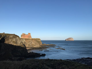
A photo of a view of Tantallon Castle and the cliffs beneath it, taken from the path to Oxroad Bay.  Photo by Kevin Nosferatu for the Skulferatu Project.
View of Tantallon Castle and cliffs from path to Oxroad Bay


A photo of a view of Tantallon Castle and the cliffs beneath it, with the Bass Rock in the sea in the background, taken from the path to Oxroad Bay.  Photo by Kevin Nosferatu for the Skulferatu Project.
View of Tantallon Castle and Bass Rock from path to Oxroad Bay


It wasn’t the most comfortable journey down, but I made it and then realised I’d have to go back up that way again.  That spoilt the joy of being in the seclusion of the bay a bit.  And it was secluded.  The tide was quite high, so the bay was completely cut off with cliffs towering above on all sides.  


The cliffs around Oxroad Bay are mainly made up of volcanic rock, however, there is a band containing cementstones in which lots of fossils have been found.  These have mainly been fragments of fish, though various species of pteridosperms and lycopods have also been discovered in them.  


Not being much of a fossil collector, I walked around the bay in the morning sunshine and watched the sea birds wading in the few feet of mud exposed by the sea.  They called out in alarm on seeing me wandering along the beach, a big, clumsy human in a bright waterproof jacket with a bunnet on his head.


A photo of the steep path that leads down from the land above to Oxroad Bay.  Photo by Kevin Nosferatu for the Skulferatu Project.
Path leading down to Oxroad Bay


A photo of a view of Tantallon Castle and the Bass Rock from Oxroad Bay.  Photo by Kevin Nosferatu for the Skulferatu Project.
View of Tantallon Castle and Bass Rock from Oxroad Bay


I found some rocks to sit on and closed my eyes.  The winter sun warmed my face and the soothing lap of the waves made me feel at one with everything around me.  Then I remembered I had to get back up the path again.  Reverie ruined, I got up and made my way back round to the path and began my ascent.  On looking at it again I realised there were only really two bits that were bad.  In total maybe ten feet of the path and for some reason I decided that running up would be easiest, as being light of foot and fast would present the least danger.  It worked, and soon I was back up on the main path.


As I made my way back, I stopped by the old wall running along the path and left a Skulferatu in a gap by a love heart shaped stone.


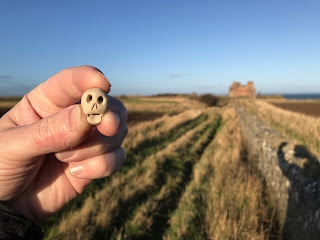
A photo of a small ceramic skull (Skulferatu 64) being held up with a wall, a field and Tantallon Castle in the background.  Photo by Kevin Nosferatu for the Skulferatu Project.
Skulferatu #64


A photo of a stone wall with a ploughed field behind it.  The sky is a cold blue.  Photo by Kevin Nosferatu for the Skulferatu Project.
Wall along the path to Oxroad Bay


A photo of a small ceramic skull (Skulferatu 64) in a gap in the stone wall, by a love heart shaped stone.  Photo by Kevin Nosferatu for the Skulferatu Project.
Skulferatu #64 in a gap in the wall


A photo of a small ceramic skull (Skulferatu 64) in a gap in the stone wall.  Photo by Kevin Nosferatu for the Skulferatu Project.
Skulferatu #64 in a gap in the wall


TomTom map showing location of Skulferatu #64 along path to Oxroad Bay.
Map showing location of Skulferatu #64


The coordinates for the location of the Skulferatu are –


Latitude 56.052649

Longitude -2.6472330


I used the following sources for information on the fossils at Oxroad Bay –


UK Fossils Network

UK Fossils - North-Berwick


Article and photographs are copyright of © Kevin Nosferatu, unless otherwise specified.