Showing posts with label East Lothian. Show all posts

Tuesday 5 April 2022

Skulferatu #65 - Anti Tank Blocks, Gosford Bay, East Lothian


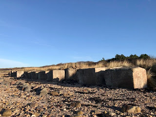
During WWII numerous coastal areas around the UK were seen as being potential landing places for a sea borne invasion by the German forces.  Given this, in many of these sites, man made obstructions were put in place to hinder any possible enemy assault.  Some of these were designed to make it difficult for landing craft to get into the shore and others were designed to slow down tanks and other vehicles if they got ashore. The Anti Tank Blocks that can be seen along stretches of the East Lothian coast line were one of the obstruction methods deployed.  These were large concrete blocks that were placed around vulnerable parts of the coast to impede and delay any tanks that were landed on the shore.


A photo showing Anti Tank Blocks on the beach near Longniddry Bents.  These are large square concrete blocks and they stretch off into the distance. Photo by Kevin Nosferatu for the Skulferatu Project.
Anti Tank Blocks on beach near Longniddry Bents


A photo of the sands near Longniddry Bents.  the tide has gone out leaving curved patterns of shallow water on the beach.  Photo by Kevin Nosferatu for the Skulferatu Project.
Sands near Longniddry Bents


A photo showing Anti Tank Blocks on the beach near Longniddry Bents.  These are large concrete blocks and they  appear to have been topples over so that they are now rectangular in shape as the bases are no longer buried in the sand. Photo by Kevin Nosferatu for the Skulferatu Project.
Anti Tank Blocks on beach near Longniddry Bents


Today, there is still a row of these blocks running along from Longniddry Bents to Gosford Bay.  Many are weathered and disappearing into the sand and pebbles of the beach, but others, such as those protected by the trees within the woods at Craigielaw, are still well-preserved and whole.


A photo showing two of the anti tank blocks in the woods at Craigielaw.  There is a large deciduous tree behind them that has shed its leaves and its branches are bare.  Photo by Kevin Nosferatu for the Skulferatu Project.
Anti Tank Blocks in the woods at Craigielaw


A photo showing a line of the anti tank blocks stretching off through the woods with the bare branches of a large tree stretching out over them.   Photo by Kevin Nosferatu for the Skulferatu Project.
Anti Tank Blocks in the woods at Craigielaw


A photo showing the concrete Anti Tank Blocks on the beach at Gosford Bay.  The beach around them is white with seashells.   Photo by Kevin Nosferatu for the Skulferatu Project.
Anti Tank Blocks on the beach at Gosford Bay


A photo showing several of the Anti Tank Blocks on the beach at Gosford Bay.  they are sitting amongst the rocks by the sea.  Photo by Kevin Nosferatu for the Skulferatu Project.
Anti Tank Blocks on the beach at Gosford Bay


A photo showing the Anti Tank Blocks on the beach at Gosford Bay.  Photo by Kevin Nosferatu for the Skulferatu Project.
Anti Tank Blocks on the beach at Gosford Bay


As well as now being an interesting historical reminder of a dark and fearful time in the UK’s history, many of the crumbling blocks are now home to insect and plant life.


On my walk, I followed the row of Anti Tank Blocks along the coast and through the woods, from Longniddry to Gosford Bay. 


A photo showing the last of the Anti Tank Blocks at Gosford Bay.  It is pitted and crumbling from the effects of the sea and the weather.  Photo by Kevin Nosferatu for the Skulferatu Project.
Last of the Anti Tank Blocks at Gosford Bay


I left the Skulferatu that accompanied me in a hollow in the last block standing amongst the rocks in Gosford Bay.


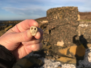
A photo showing a small ceramic skull (Skulferatu #65) being held up in front of the last of the anti tank blocks at Gosford Bay.  Photo by Kevin Nosferatu for the Skulferatu Project.
Skulferatu #65


A photo showing a small ceramic skull (Skulferatu #65) in one of the pitted hollows of the last anti tank block at Gosford Bay.  Photo by Kevin Nosferatu for the Skulferatu Project.
Skulferatu #65 in a hollow in the Anti Tank Block


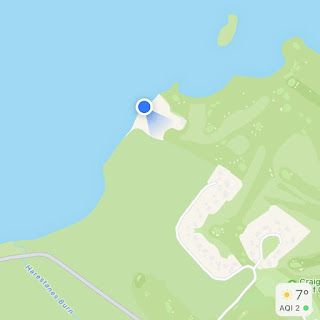
TomTom map showing location of Skulferatu #65
Map showing location of Skulferatu #65


The coordinates for the location of the Skulferatu are –


Latitude 56.004890

Longitude -2.889890


I used the following sources for information on the Anti Tank Blocks –


Canmore - Gosford Sands


Tuesday 7 December 2021

Skulferatu #52 - XT-Craft Midget Submarine Wrecks, Aberlady Bay, East Lothian


About a mile away from the picturesque village of Aberlady, there is a rather lovely walk through a nature reserve that stretches along the coast on one side of Aberlady Bay.  The path through this takes you through a wooded area and out onto a stretch of land covered in sea grasses and reeds.  From there it leads onto some huge sand dunes and a gorgeous sandy beach that seems to stretch out forever at low tide.  Today, I walked out there from Aberlady.  The sun shone through a wind that howled in from the sea and it was both warm and freezing at the same time.  Typical British beach weather basically.


As I made my way out along the beach towards the retreating sea, I took off my socks and shoes and walked though pitted puddles in the sand to the watery graves of two submarines. 


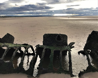
A picture of the skeletal remains of a wrecked submarine lying on the sands of the beach at Aberlady Bay, East Lothian.  In the distance can be seen the concrete block it was tethered to, along with the remains of another submarine.  Photograph by Kevin Nosferatu for the Skulferatu Project.
Remains of one of the submarines with the other away in the distance


These are not as you may think German submarines sunk during World War II but are rather a couple of British mini submarines that were used by the RAF for target practice.


A picture of the remains of one of the wrecked XT-Craft midget submarines lying on its side in the sands at Aberlady Bay.  Photograph by Kevin Nosferatu for the Skulferatu Project
Remains of one of the wrecked XT-Craft midget submarines


They are the remains of two XT-Craft midget submarines.  These are training versions of the X-Craft submarines which were built in Britain during the Second World War and were designed to defend harbours and attack targets.  They were used on the attack of the German battleship Tirpitz in 1943 and were used during the D-Day landings to carry out beach reconnaissance and act as navigational beacons.


A picture of the rusting and seaweed covered remains of the hatch of one of the wrecked submarines.  Photograph by Kevin Nosferatu for the Skulferatu Project
The hatch of one of the wrecked submarines


A photo of a rusting metal tower on the wrecked remains of the submarine.  Photograph by Kevin Nosferatu for the Skulferatu Project.
Detail of one of the wrecked submarines


A photo of the skeletal and rusting remains of one of the submarines with the metal ribs of the vessel on show.  Photograph by Kevin Nosferatu for the Skulferatu Project.
Rusting remains of one of the submarines


A photo of the inside of the rusting remains of one of the submarines.  Photograph by Kevin Nosferatu for the Skulferatu Project.
Inside view of one of the submarines


A photo of one of the wrecked submarines in silhouette with clouds above stretching off into the distance.  Photograph by Kevin Nosferatu for the Skulferatu Project.
View of one of the wrecked submarines on the beach


In 1946 these two submarines were towed out to Aberlady bay and moored to concrete blocks.  They were then used to test the effectiveness of 20mm cannon shells, which were fired at them by RAF aircraft.  The film of these tests taking place is available on YouTube at –


After the tests were completed the damaged remains of the submarines were left to rust away in the sea.


I left the Skulferatu that accompanied me on my walk in a hole in the rusting interior of one of the submarines.


A photograph of a small, ceramic skull (Skulferatu 52) being held in a hand with one of the wrecked submarines lying on the beach in the background.  Photograph by Kevin Nosferatu for the Skulferatu Project.
Skulferatu #52


A photograph showing the rusting and barnacle covered interior of submarine where Skulferatu 52 was left.  There is a small, round hole in the centre of the rusting metal.  Photograph by Kevin Nosferatu for the Skulferatu Project.
Interior of submarine where Skulferatu #52 was left


A photograph of the small, ceramic skull (Skulferatu 52) lying in the small hole in the rusting metal of the wrecked submarine.  Photograph by Kevin Nosferatu for the Skulferatu Project.
Skulferatu #52 inside the wreck of one of the submarines


TomTom Map showing location of Skulferatu #52
Map showing location of Skulferatu #52


The coordinates for the location of the Skulferatu are –


Latitude 56.022681

Longitude -2.880941


I used the following sources for information on the submarines –


Canmore

X-craft: Aberlady Bay, Firth Of Forth | Canmore


Aberlady Heritage

Midget Submarines, Aberlady Bay, Summary Report by Alison Boutland


Tuesday 27 July 2021

Skulferatu #38 - Torness Nuclear Power Station, Dunbar, East Lothian


A postcard showing various views around Torness Nuclear Power Station.  Photo by Kevin Nosferatu for the Skulferatu Project
Have a Nuclear Time at Terrific Torness!


Is it wrong to have a favourite nuclear power station?  Well, I do, and it is Torness Nuclear Power Station situated just a few miles down the road from the town of Dunbar.  It can be reached by car along the A1, or by walking out from Dunbar and then along the coastal path of the John Muir Way.  I took the coastal route and walked there, past Barns Ness Lighthouse, and along through the sandy paths with the sharp grasses that grow there.  Following the coast around I then came to the lime kilns at Skateraw and going up and over the hill by them, arrived at the coastal concrete walkways that lead round and past the power station and on to Torness Point and Thorntonloch Beach.


Wall and fields of tall grass stretching off into distance with the large structure of Torness Nuclear Power Station rising up in the background.  Photo by Kevin Nosferatu for the Skulferatu Project
Rural walk to Torness Nuclear Power Station


Flat grass land stretching off into distance with the large structure of Torness Nuclear Power Station rising up in the background.  Photo by Kevin Nosferatu for the Skulferatu Project
Rural walk to Torness Nuclear Power Station


Torness Nuclear Power Station as seen from Skateraw - a memorial cross rises from the tall grasses on one side and the structure of the power station dominates the other.  Photo by Kevin Nosferatu for the Skulferatu Project
Torness Nuclear Power Station as seen from Skateraw


Torness Nuclear Power Station as seen from Skateraw - on one side of the bay is a bare rock surface leading to the water and on the other side is the power station.  Photo by Kevin Nosferatu for the Skulferatu Project
Torness Nuclear Power Station as seen from Skateraw


The lower and upper walkway around the coast by the power station were constructed as a sea defence.  Part of this defence are the thousands of distinctive looking concrete blocks that rise up from the sea to the wall of the lower walkway.  These blocks are known as Dolos Units and are used as protection against the erosive force of the waves and rough seas.  They work by dissipating the energy from the wave by deflecting it to the side and thus lessening any erosion or damage. These blocks and the bare concrete of the walkways create quite a stark, yet dramatic feature in the landscape.


Torness Nuclear Power Station as seen from the walkway pier - at the front of the picture are the concrete Dolos leading down to a bay in which sits a lifeboat and on the other side of the water is the power station.  Photo by Kevin Nosferatu for the Skulferatu Project
Torness Nuclear Power Station as seen from the walkway pier


Walkway and Dolos - a picture showing the grey concrete of the walkway, the wall around it and the concrete Dolos.  The sky in the background is bright with white clouds.  Photo by Kevin Nosferatu for the Skulferatu Project
Walkway and Dolos


Lower walkway around grounds of Torness Nuclear Power Station.  Picture shows the concrete walkway and walls with a cloudy sky in the background.  Photo by Kevin Nosferatu for the Skulferatu Project
Lower walkway around grounds of the power station


Torness Nuclear Power Station was the last of the United Kingdom’s second generation nuclear power plants to be commissioned, and it is one of the seven remaining nuclear power stations in the UK.  Like all the remaining nuclear power stations, Torness was built beside the sea, as nuclear reactors need access to large quantities of water to keep the core at a stable temperature.  The sea water is also used to generate steam to drive a turbine which in turn powers the generator.


Torness Nuclear Power Station - a picture showing the white structure of the power station and how it almost blends into the clouds above.  Photo by Kevin Nosferatu for the Skulferatu Project
Torness Nuclear Power Station


Construction began on Torness in 1980 and by 1988 the power station had been completed and was generating electricity.  The power station has two Advanced Gas-cooled Reactors and supplies around 1,190MW (megawatts) to the National Grid.  In 2019 it generated more than 10TWh (Terawatt-hours), which was enough to power 2.5 million homes. 


Torness is expected to operate until around 2030 before being decommissioned.


I left the Skulferatu that accompanied me on today’s walk amongst the rocks forming part of the sea defences by the beach at the southeast side of the power station.


Torness Nuclear Power Station as seen from beach by Torness Point - picture shows sand dune and grass with the power station in the background with a sky of white clouds.  Photo by Kevin Nosferatu for the Skulferatu Project
Torness Nuclear Power Station as seen from beach by Torness Point


Skulferatu #38 - picture shows a small, clay skull being held up with Torness Power Station in the background.  Photo by Kevin Nosferatu for the Skulferatu Project
Skulferatu #38


Skulferatu #38 on rock by Torness Point - picture shows small, clay skull on a rock.  Photo by Kevin Nosferatu for the Skulferatu Project
Skulferatu #38 on rock by Torness Point


Skulferatu #38 on rock by Torness Point - picture shows small, clay skull on a rock.  Photo by Kevin Nosferatu for the Skulferatu Project
Skulferatu #38 on rock by Torness Point


Skulferatu #38 on rock by Torness Point - picture shows small, clay skull on a rock, amongst lots of rocks with Torness Nuclear Power Station in the background.  Photo by Kevin Nosferatu for the Skulferatu Project
Skulferatu #38 on rock by Torness Point


Map showing location of Skulferatu #38


The coordinates for the location of the Skulferatu are –


Latitude 55.966443

Longitude -2.399051


I used the following sources for information on Torness Nuclear Power Station –


EDF Energy – Torness

Torness Power Station


Nuclear Generation in the UK

Published by EDF Energy


East Lothian Courier – 3 September 2020


Wikipedia

Torness Nuclear Power Station

Dolos


Article and photographs are copyright of © Kevin Nosferatu, unless otherwise specified.


Tuesday 15 June 2021

Skulferatu #34 - Tranent Doocot, Dovecot Brae, Tranent, East Lothian


I took a cycle out to Tranent in East Lothian and stopped off along Dovecot Brae, by a crumbling, old building that is now virtually hidden amongst trees and undergrowth.  If it weren’t for the stairs leading up from the road, it would be easy to go right past this place and not even notice it was there.  At first this building, Tranent Doocot, appears to have no great importance or relevance, but there is a dark history associated with the man who ordered its construction.


Stairs leading up to Tranent Doocot, which is almost hidden in the deep green of trees and undergrowth.  Photograph by Kevin Nosferatu for The Skulferatu Project.
Stairs leading up to Tranent Doocot, which is almost hidden in trees and undergrowth


Tranent Doocot – almost hidden in trees and undergrowth.  The Doocot has a dark history associated with the man who ordered its construction, David Setoun or Seton, as he is now known, was one of the main instigators in starting what later became known as the North Berwick Witch Trials.  Photograph by Kevin Nosferatu for The Skulferatu Project.
Tranent Doocot – almost hidden in trees and undergrowth


According to J Sands in his book published in 1881 'Sketches of Tranent in the Olden Times', Tranent Doocot used to bear the name of David Setoun and the date 1587.  In the present day, this inscription is completely illegible, which is not a bad thing given that David Setoun or Seton, as he is now known, was one of the main instigators in starting what later became known as the North Berwick Witch Trials. 


Entrance to Tranent Doocot.  Photograph by Kevin Nosferatu for The Skulferatu Project.
Entrance to Tranent Doocot


Pigeonholes inside the doocot for the birds to nest in.  Photograph by Kevin Nosferatu for The Skulferatu Project.
Pigeonholes inside the doocot for the birds to nest in.


David Seton was the Deputy Bailiff in Tranent to Lord Seton and to make things nice and confusing David Seton also had a son called David.  In various descriptions of him, David Seton Snr appears to be a mean spirited, suspicious man who believed that his woes and financial difficulties were caused by others committing ungodly acts against him.  He, and his family resided in Tranent in a house that was commonly known as the Royal George, and in their employment was a maid servant called Geillis Duncan.   Duncan is believed to have been in her early to mid-teens when employed by Seton and is described as being '...young and comely, and distinguished for her readiness to attend the sick and infirm, and for her wonderful skill in curing diseases.' 
 
In November 1590 David Seton became suspicious of Duncan’s growing reputation as a healer and became convinced that witchcraft must be involved.  He then questioned her about this, and she denied the accusations.  Not satisfied with this Seton gathered together some associates and together they tortured Duncan.  First, they used an item called the 'pilliwinks' on her, or what we would today call thumbscrews.  These crushed the thumbs and caused great pain.  However, despite this Duncan would not confess.  Seton and his associates then bound and wrenched her head with a rope to cause her extreme agony, but still, she would confess nothing. They then stripped and shaved her and examined her body for the mark of the Devil, as it was believed that those in the service of Satan had a mark put upon them that was insensible to pain and did not bleed when pricked.  On 'finding' this mark on Duncan's neck Seton and his cronies stated that she then admitted that her looking after the sick had been done at the suggestion of the Devil and that her curing of disease was done by witchcraft.  She went on to name thirty accomplices.  Duncan, and all those she had named, were then imprisoned.
 
Terrified, tormented and tortured those imprisoned soon confessed to a multitude of bizarre crimes including attempting to bring about the death of King James VI.  The strange and wonderful story that emerged was that the coven of witches met in the house of Barbara Napier in Edinburgh.  Napier was a member of Edinburgh high society and was Lady-in-Waiting to the Countess of Angus.  She had fallen out with the Countess and had then supposedly brought about the death of the Earl of Angus through the use of witchcraft.  As well as meeting at Napier’s house, there had been a meeting of around two hundred witches at Acheson's Haven (now Morrison's Haven, Prestongrange) and later another meeting at the Kirk of North Berwick.  The Devil presided over these gatherings and Dr John Fian, a schoolteacher from Prestonpans, acted as the secretary.  The coven had met to devise a plan to destroy the ship that carried the newly married King James and his wife Anne from Denmark to Leith.  At one of these meetings another member of Edinburgh high society, Euphame MacCalzean, handed a waxen image of King James to the Devil and hinted that the Earl of Bothwell, with whom she was closely connected, would be the new king.
 
After the meeting at North Berwick a group of witches and wizards set sail in sieves to meet the Royal ship.  During their voyage they boarded a passing ship and after helping themselves to food and drink, sunk it.  They then carried on with their voyage and on sighting the Royal ship the Devil handed a cat, that had earlier been baptised, to Dr Fian and ordered him to throw it into the sea and cry 'Halo!'  On his doing this a tremendous storm arose and being convinced that nothing but a miracle could save the Royal ship from destruction, the Devil and all those gathered returned to North Berwick.  There they marched with their sieves in their hands to the Kirk.  Geillis Duncan led the procession playing a quick step on the Jews Harp.  At the Kirk they all entered, and the Devil preached a sermon to them from the pulpit.  He asked all those assembled to do all the evil in their power and that if they did so, they'd be handsomely rewarded.  He then bent over the pulpit and asked those assembled to kiss his buttocks as a token of their allegiance.  They all did so before making their way out into the churchyard where they feasted on the dead and were given parts of human bodies by the Devil as powerful charms.  Geillis Duncan then played a reel on the Jews Harp called - 'Cummer, go ye before Cummer, go ye.'
 
All those seized and accused of witchcraft were tortured horribly to make them confess to their roles in the plot.  Dr Fian, the alleged secretary to the Devil and cat thrower, had his legs crushed in the 'bootikens' until 'the blood and marrow spouted out'.  His fingernails were then pulled out and pins pushed into his fingers, however unlike many of the others, he refused to confess to anything. 
 
King James took a keen interest in all the proceedings of these witch trials, as he fully believed that an attempt had been made on his life by Satan and his little helpers.  Though why Satan would be interested in the King of a small, poor country at the arse end of Europe is anyone's guess.  You would have thought that given the chaos that would later be caused by King James' son Charles, that the Devil would have been only too keen to keep James and his offspring on the throne.  Though maybe, unlike God, the Devil does not reside outside of time and is therefore unaware of what is to come.  Anyway, getting back to the story - King James attended to see the witnesses examined and put to torture and also had Geillis Duncan brought to Holyrood Palace in Edinburgh.  There he had her play the reel on the Jews Harp that she had played for the Devil and all the assembled witches and wizards at North Berwick.
 
Various trials then took place and on 26 December 1590 John Fian was tried and found guilty of numerous charges including being involved in the plot against King James.  He was sentenced to death and it appears that he may have been taken to Castle Hill and strangled and burned there later on the same day.
 
Barbara Napier was tried and found guilty of consulting with witches and was sentenced to death.  On 10 May 1591 she was taken to Castle Hill, Edinburgh where she was bound to a stake to be strangled and burned.  However, she claimed to be pregnant and was given a stay of execution.  It is unclear what then happened to her.
 
Euphame MacCalzean was found guilty of being a witch and consulting with witches.  She was sentenced to death, though cruelly and unusually was sentenced to death by being burned alive.  The sentence was carried out on Castle Hill on the 25 June 1591.
 
No trial records have ever been recovered for Geillis Duncan.  However, she was convicted of witchcraft and was executed on 4 December 1591 at Castle Hill in Edinburgh, presumably like the others by being strangled and then burned to ashes.  She was executed along with Bessie Thomson, another woman convicted of witchcraft, and both recanted their confessions prior to execution.  On being asked why she had confessed and named others such as Barbara Napier and Euphame MacCalzean in her confessions Duncan stated that she had been made to by the two David Setons in Tranent and others, but that it was all lies and for this she begged God's forgiveness.
 
Many of those named by Duncan went on to name others involved in the so called plot against the King, and by 1593 over 70 people had been implicated and many had been executed.  Now, I may be being very cynical about the reasons for many of these people being accused, as I am aware that there were many religious, political, and socio-economic things going on at this time.  However, it is very interesting to note that Dr John Fian had been in a long running dispute with David Seton, while Euphame MacCalzean was Seton’s sister-in-law.  Seton was angry with her, as she had inherited money from a relative that he thought should have been bequeathed to him.  So, at the very least Seton would appear to be guilty of capitalising on a situation, he had started, for revenge against enemies, perceived and real.
 
 
*           *           *
 
Tranent Doocot stands near to Tranent Old Parish Church and was built to house 1122 pairs of pigeons.  The pigeons were a good supply of fresh meat for the local population, who would take the young pigeons, as their meat was the most tender and juicy.  The building has been partially restored but is again in a state of disrepair.  I'm glad that the name of David Seton has faded from this building, as it is a name that deserves to be forgotten.  Instead let us remember the names of those who died in an age of paranoia, religious intolerance, and political intrigue.


Tranent Old Parish Church with Doocot on right hand side.  Photograph by Kevin Nosferatu for The Skulferatu Project.
Tranent Old Parish Church with Doocot on right hand side


I left a Skulferatu here for Geillis Duncan and all the others who were persecuted and murdered for imaginary crimes created in the overactive imaginations of jealous or malicious peers and a paranoid ruling class.


Skulferatu #34 outside Tranent Doocot.  Photograph by Kevin Nosferatu for The Skulferatu Project.
Skulferatu #34


Skulferatu #34 in hollow of wall at Tranent Doocot.  Photograph by Kevin Nosferatu for The Skulferatu Project.
Skulferatu #34 in hollow of wall at Tranent Doocot


Skulferatu #34 in hollow of wall at Tranent Doocot.  Photograph by Kevin Nosferatu for The Skulferatu Project.
Skulferatu #34 in hollow of wall at Tranent Doocot


Google map showing location of Skulferatu #34 at Tranent Doocot
Map showing location of Skulferatu #34


The coordinates for the location of the Skulferatu are –


Latitude 55.950036

Longitude -2.957936


I used the following sources for the tale of Geillis Duncan -


Witchcraft in Early Modern Scotland

edited by Lawrence Normand and Gareth Roberts (2000)


Sketches of Tranent in the Olden Times

by J Sands (1881)

Available digitally at https://electricscotland.com/history/tranent/chapter03.htm


Tranent and its Surroundings

by P McNeill (1884)

https://archive.org/details/tranentitssurrou02mnei/mode/2up


Geillis Duncan, Witch

https://engole.info/geillis-duncan-witch/


Wikipedia - Morrison's Haven

Morrison's Haven - Wikipedia


Article and photographs are copyright of © Kevin Nosferatu, unless otherwise stated.